Property Record
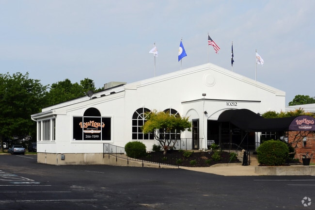
10212 Taylorsville Rd, Louisville, KY 40299


Property Detail
10212 Taylorsville Rd
004501610000
1.4526 AC SWS TAYLORSVILLE RD 140 X 454 AVG
Restaurantbuilding
Jefferson
C1-COMMERC
Kentucky
B and X Area of moderate flood hazard, usually the area between the limits of the 100-year and 500-year floods.
1.45 AC
2025
Southeast
2025
Louisville
011118
Louisville/Jefferson County, KY-IN
4,959 SF
NEARBY LISTINGS FOR SALE OR LEASE
DEMOGRAPHICS near 10212 Taylorsville Rd
1 mile
3 mile
5 mile
2025 Total Population
10,006
71,576
179,826
2030 Population
10,092
72,752
183,443
Pop Growth 2025-2030
+ 0.86%
+ 1.64%
+ 2.01%
Average Age
39
41
41
2025 Total Households
4,289
29,794
76,950
HH Growth 2025-2030
+ 0.86%
+ 1.73%
+ 2.10%
Median Household Inc
$65,438
$81,974
$76,799
Avg Household Size
2.30
2.40
2.30
2025 Avg HH Vehicles
2.00
2.00
2.00
Median Home Value
$227,894
$288,804
$284,765
Median Year Built
1974
1985
1980
Nearby Places
Map Layers
Map Styles
 Street
 Aerial
Transit
 Traffic
 Biking
Places
Listings with unknown addresses are not visible on the map
- Restaurants
- Banks
- Shops
- Fitness
- Groceries
PUBLIC TRANSPORTATION
AIRPORT
Louisville Muhammad Ali International
Drive
Walk
Distance
Louisville Muhammad Ali International
27 min
13.1 mi
Nearby Properties
Address
Land Use
TOTAL SIZE
Lot Size
Zoning
Address
Land Use
TOTAL SIZE
Lot Size
Zoning
115.43 AC
R4-RESIDEN
Address
Land Use
TOTAL SIZE
Lot Size
Zoning
2,776 SF
34.17 AC
R4-RESIDEN
Address
Land Use
TOTAL SIZE
Lot Size
Zoning
1,194 SF
38.74 AC
R4-RESIDEN
Address
Land Use
TOTAL SIZE
Lot Size
Zoning
1,334 SF
24.71 AC
R4-RESIDEN
Address
Land Use
TOTAL SIZE
Lot Size
Zoning
2,140 SF
18.35 AC
R4-RESIDEN
Address
Land Use
TOTAL SIZE
Lot Size
Zoning
8.47 AC
R1-RESIDEN
Address
Land Use
TOTAL SIZE
Lot Size
Zoning
45.92 AC
Address
Land Use
TOTAL SIZE
Lot Size
Zoning
19.57 AC
Address
Land Use
TOTAL SIZE
Lot Size
Zoning
202,557 SF
6.06 AC
C2-COMMERC
Address
Land Use
TOTAL SIZE
Lot Size
Zoning
31,968 SF
15.34 AC
R4-RESIDEN
Address
Land Use
TOTAL SIZE
Lot Size
Zoning
175,971 SF
18.54 AC
PEC-PLANNE
Address
Land Use
TOTAL SIZE
Lot Size
Zoning
19,568 SF
24.23 AC
R7-RESIDEN
Address
Land Use
TOTAL SIZE
Lot Size
Zoning
9,560 SF
20.31 AC
C1-COMMERC
Address
Land Use
TOTAL SIZE
Lot Size
Zoning
10,026 SF
13.45 AC
R6-RESIDEN
Address
Land Use
TOTAL SIZE
Lot Size
Zoning
18,784 SF
16.80 AC
R6-RESIDEN
Address
Land Use
TOTAL SIZE
Lot Size
Zoning
9,844 SF
15.11 AC
R6-RESIDEN
Address
Land Use
TOTAL SIZE
Lot Size
Zoning
6,846 SF
18.36 AC
R4-RESIDEN
Address
Land Use
TOTAL SIZE
Lot Size
Zoning
910 SF
9.77 AC
R6-RESIDEN
Address
Land Use
TOTAL SIZE
Lot Size
Zoning
28.91 AC
R4-RESIDEN
Address
Land Use
TOTAL SIZE
Lot Size
Zoning
335,400 SF
18.84 AC
PEC-PLANNE
Address
Land Use
TOTAL SIZE
Lot Size
Zoning
18,084 SF
10.68 AC
R7-RESIDEN
Address
Land Use
TOTAL SIZE
Lot Size
Zoning
Address
Land Use
TOTAL SIZE
Lot Size
Zoning
2,665 SF
6.72 AC
R4-RESIDEN
Address
Land Use
TOTAL SIZE
Lot Size
Zoning
159,847 SF
5.23 AC
PEC-PLANNE
Address
Land Use
TOTAL SIZE
Lot Size
Zoning
110,088 SF
8.69 AC
PEC-PLANNE
Address
Land Use
TOTAL SIZE
Lot Size
Zoning
51,076 SF
9.77 AC
OR3-OFFICE
Address
Land Use
TOTAL SIZE
Lot Size
Zoning
10.44 AC
PEC-PLANNE
Address
Land Use
TOTAL SIZE
Lot Size
Zoning
17,648 SF
8.96 AC
R6-RESIDEN
Address
Land Use
TOTAL SIZE
Lot Size
Zoning
48,000 SF
29.85 AC
PEC-PLANNE
Address
Land Use
TOTAL SIZE
Lot Size
Zoning
13,810 SF
12.69 AC
R6-RESIDEN
The World's #1 Commercial Real Estate Marketplace
Connect with us
© 2026 CoStar Group
The information above has been obtained from sources believed reliable. While we do not doubt its accuracy we have not verified it and make no guarantee, warranty or representation about it. It is your responsibility to independently confirm its accuracy and completeness. Any projections, opinions, assumptions, or estimates used are for example only and do not represent the current or future performance of the property. The value of this transaction to you depends on tax and other factors which should be evaluated by your tax, financial, and legal advisors. You and your advisors should conduct a careful, independent investigation of the property to determine to your satisfaction the suitability of the property for your needs.