Property Record
7625 Katy Fwy, Houston, TX 77024
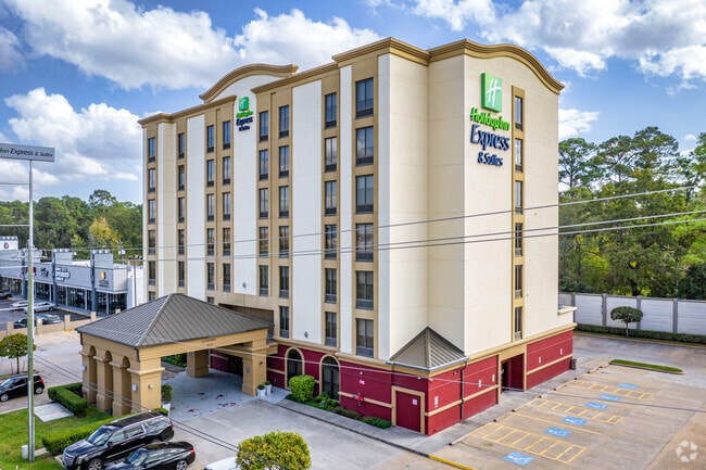

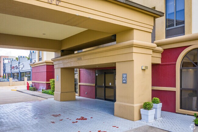
Property Detail
7625 Katy Fwy
1209230010001
Silver Hospitality
Hotel
RES A BLK 1 SILVER HOSPITALITY
X
Harris
48201C0665M
Texas
2023
1.07 AC
2025
Katy Freeway West
430101
Houston
52,058 SF
Houston-Pasadena-The Woodlands, TX
NEARBY LISTINGS FOR SALE OR LEASE
DEMOGRAPHICS near 7625 Katy Fwy
1 mile
3 mile
5 mile
2024 Total Population
12,825
137,452
499,665
2029 Population
13,493
143,241
517,657
Pop Growth 2024-2029
+ 5.21%
+ 4.21%
+ 3.60%
Average Age
41
40
38
2024 Total Households
5,704
63,933
226,600
HH Growth 2024-2029
+ 5.17%
+ 4.37%
+ 3.69%
Median Household Inc
$94,491
$95,385
$81,376
Avg Household Size
2.20
2.10
2.20
2024 Avg HH Vehicles
2.00
2.00
2.00
Median Home Value
$775,695
$584,890
$498,009
Median Year Built
1990
1992
1988
Nearby Places
Map Layers
Map Styles
 Street
 Aerial
Transit
 Traffic
 Biking
Places
Listings with unknown addresses are not visible on the map
- Restaurants
- Banks
- Shops
- Fitness
- Groceries
PUBLIC TRANSPORTATION
COMMUTER RAIL
Drive
Walk
Distance
12 min
7.5 mi
AIRPORT
William P Hobby
Drive
Walk
Distance
William P Hobby
32 min
19.8 mi
George Bush Intcntl/Houston
Drive
Walk
Distance
George Bush Intcntl/Houston
32 min
23.8 mi
Freight Ports
Port of Houston
Drive
Walk
Distance
Port of Houston
26 min
16.6 mi
Nearby Properties
Address
Land Use
TOTAL SIZE
Lot Size
Zoning
Address
Land Use
TOTAL SIZE
Lot Size
Zoning
2,404,389 SF
16.01 AC
Address
Land Use
TOTAL SIZE
Lot Size
Zoning
716,631 SF
7.04 AC
Address
Land Use
TOTAL SIZE
Lot Size
Zoning
580,059 SF
2.48 AC
Address
Land Use
TOTAL SIZE
Lot Size
Zoning
832,304 SF
6.24 AC
Address
Land Use
TOTAL SIZE
Lot Size
Zoning
608,704 SF
1.52 AC
Address
Land Use
TOTAL SIZE
Lot Size
Zoning
748,071 SF
4.13 AC
Address
Land Use
TOTAL SIZE
Lot Size
Zoning
771,702 SF
2.51 AC
Address
Land Use
TOTAL SIZE
Lot Size
Zoning
576,200 SF
2.65 AC
Address
Land Use
TOTAL SIZE
Lot Size
Zoning
527,312 SF
2.58 AC
Address
Land Use
TOTAL SIZE
Lot Size
Zoning
612,663 SF
7 AC
Address
Land Use
TOTAL SIZE
Lot Size
Zoning
432,689 SF
2.84 AC
Address
Land Use
TOTAL SIZE
Lot Size
Zoning
549,506 SF
2.05 AC
Address
Land Use
TOTAL SIZE
Lot Size
Zoning
622,578 SF
1.51 AC
Address
Land Use
TOTAL SIZE
Lot Size
Zoning
392,218 SF
1.21 AC
Address
Land Use
TOTAL SIZE
Lot Size
Zoning
1,012,117 SF
3.29 AC
Address
Land Use
TOTAL SIZE
Lot Size
Zoning
1,819,963 SF
5.30 AC
Address
Land Use
TOTAL SIZE
Lot Size
Zoning
214,297 SF
15.23 AC
Address
Land Use
TOTAL SIZE
Lot Size
Zoning
402,886 SF
17.95 AC
Address
Land Use
TOTAL SIZE
Lot Size
Zoning
495,834 SF
1.49 AC
Address
Land Use
TOTAL SIZE
Lot Size
Zoning
415,160 SF
4.47 AC
Address
Land Use
TOTAL SIZE
Lot Size
Zoning
495,474 SF
5.56 AC
Address
Land Use
TOTAL SIZE
Lot Size
Zoning
571,822 SF
3.35 AC
Address
Land Use
TOTAL SIZE
Lot Size
Zoning
133,258 SF
11.56 AC
Address
Land Use
TOTAL SIZE
Lot Size
Zoning
515,130 SF
2.72 AC
Address
Land Use
TOTAL SIZE
Lot Size
Zoning
224,114 SF
4.24 AC
Address
Land Use
TOTAL SIZE
Lot Size
Zoning
702,286 SF
15.67 AC
Address
Land Use
TOTAL SIZE
Lot Size
Zoning
561,732 SF
6.10 AC
Address
Land Use
TOTAL SIZE
Lot Size
Zoning
281,973 SF
11.56 AC
Address
Land Use
TOTAL SIZE
Lot Size
Zoning
714,049 SF
25.73 AC
Address
Land Use
TOTAL SIZE
Lot Size
Zoning
385,587 SF
3.08 AC
The World's #1 Commercial Real Estate Marketplace
Connect with us
© 2026 CoStar Group
The information above has been obtained from sources believed reliable. While we do not doubt its accuracy we have not verified it and make no guarantee, warranty or representation about it. It is your responsibility to independently confirm its accuracy and completeness. Any projections, opinions, assumptions, or estimates used are for example only and do not represent the current or future performance of the property. The value of this transaction to you depends on tax and other factors which should be evaluated by your tax, financial, and legal advisors. You and your advisors should conduct a careful, independent investigation of the property to determine to your satisfaction the suitability of the property for your needs.