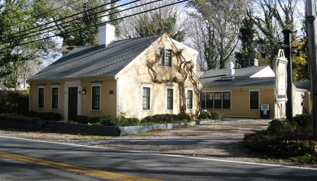
Property Record
43 Route 6A, Yarmouth Port, MA 02675

Save to a Folder
{{folder.Name}}
{{folder.ListingIds.length}} Properties
{{folder.ListingIds.length}} Property
Create a New Folder
Property Detail
43 Route 6A
YARM-000112-000031
Barnstable
Commercialofficeresidentialmixeduse
Massachusetts
B and X Area of moderate flood hazard, usually the area between the limits of the 100-year and 500-year floods.
0.70 AC
2025
Cape Cod
2025
Other Market Areas
011802
Barnstable Town, MA
3,423 SF
NEARBY LISTINGS FOR SALE OR LEASE
DEMOGRAPHICS near 43 Route 6A
1 mile
3 mile
5 mile
2025 Total Population
1,004
12,482
53,355
2030 Population
965
12,273
53,408
Pop Growth 2025-2030
(3.88%)
(1.67%)
+ 0.10%
Average Age
53
50
48
2025 Total Households
440
5,549
23,776
HH Growth 2025-2030
(4.09%)
(2.07%)
+ 0.04%
Median Household Inc
$122,465
$99,946
$81,029
Avg Household Size
2.20
2.20
2.10
2025 Avg HH Vehicles
2.00
2.00
2.00
Median Home Value
$724,913
$602,675
$572,868
Median Year Built
1979
1978
1973
Nearby Places
Map Layers
Map Styles
 Street
 Aerial
Layers
 Traffic
 Biking
Places
Listings with unknown addresses are not visible on the map
- Restaurants
- Banks
- Shops
- Fitness
- Groceries
PUBLIC TRANSPORTATION
COMMUTER RAIL
Hyannis (CapeFLYER - Cape Cod Regional Transit Authority)
Drive
Walk
Distance
Hyannis (CapeFLYER - Cape Cod Regional Transit Authority)
7 min
3.4 mi
AIRPORT
Martha's Vineyard
Drive
Walk
Distance
Martha's Vineyard
109 min
41.5 mi
Freight Ports
Port of New Bedford Harbor
Drive
Walk
Distance
Port of New Bedford Harbor
70 min
50.2 mi
Nearby Properties
Address
Land Use
TOTAL SIZE
Lot Size
Zoning
Address
Land Use
TOTAL SIZE
Lot Size
Zoning
10.68 AC
Address
Land Use
TOTAL SIZE
Lot Size
Zoning
25.88 AC
HB;B
Address
Land Use
TOTAL SIZE
Lot Size
Zoning
298,272 SF
9.34 AC
IN
Address
Land Use
TOTAL SIZE
Lot Size
Zoning
17.95 AC
VB-A;R
Address
Land Use
TOTAL SIZE
Lot Size
Zoning
11,698 SF
34.50 AC
Address
Land Use
TOTAL SIZE
Lot Size
Zoning
110,415 SF
70 AC
Address
Land Use
TOTAL SIZE
Lot Size
Zoning
43.50 AC
IN
Address
Land Use
TOTAL SIZE
Lot Size
Zoning
177,385 SF
39.53 AC
Address
Land Use
TOTAL SIZE
Lot Size
Zoning
54,172 SF
17.97 AC
IND;B;
Address
Land Use
TOTAL SIZE
Lot Size
Zoning
117,584 SF
9.68 AC
IND;B
Address
Land Use
TOTAL SIZE
Lot Size
Zoning
32.95 AC
IN
Address
Land Use
TOTAL SIZE
Lot Size
Zoning
167,800 SF
9.73 AC
IN
Address
Land Use
TOTAL SIZE
Lot Size
Zoning
13.46 AC
IN
Address
Land Use
TOTAL SIZE
Lot Size
Zoning
4,800 SF
414.61 AC
Address
Land Use
TOTAL SIZE
Lot Size
Zoning
8.09 AC
Address
Land Use
TOTAL SIZE
Lot Size
Zoning
16.63 AC
IN
Address
Land Use
TOTAL SIZE
Lot Size
Zoning
2,084 SF
20.03 AC
Address
Land Use
TOTAL SIZE
Lot Size
Zoning
2,560 SF
100.38 AC
Address
Land Use
TOTAL SIZE
Lot Size
Zoning
110.62 AC
RF-1;R
Address
Land Use
TOTAL SIZE
Lot Size
Zoning
10.21 AC
IN
Address
Land Use
TOTAL SIZE
Lot Size
Zoning
4.11 AC
Address
Land Use
TOTAL SIZE
Lot Size
Zoning
3.54 AC
Address
Land Use
TOTAL SIZE
Lot Size
Zoning
Address
Land Use
TOTAL SIZE
Lot Size
Zoning
40,332 SF
2.26 AC
IND;IN
Address
Land Use
TOTAL SIZE
Lot Size
Zoning
800 SF
7.30 AC
MB
Address
Land Use
TOTAL SIZE
Lot Size
Zoning
58,848 SF
6.20 AC
IN
Address
Land Use
TOTAL SIZE
Lot Size
Zoning
22,795 SF
8.27 AC
IND;RG
Address
Land Use
TOTAL SIZE
Lot Size
Zoning
59,756 SF
9.56 AC
Address
Land Use
TOTAL SIZE
Lot Size
Zoning
46,684 SF
7.81 AC
IN
Address
Land Use
TOTAL SIZE
Lot Size
Zoning
37,182 SF
5.13 AC
The World's #1 Commercial Real Estate Marketplace
Connect with us
© 2026 CoStar Group
The information above has been obtained from sources believed reliable. While we do not doubt its accuracy we have not verified it and make no guarantee, warranty or representation about it. It is your responsibility to independently confirm its accuracy and completeness. Any projections, opinions, assumptions, or estimates used are for example only and do not represent the current or future performance of the property. The value of this transaction to you depends on tax and other factors which should be evaluated by your tax, financial, and legal advisors. You and your advisors should conduct a careful, independent investigation of the property to determine to your satisfaction the suitability of the property for your needs.