Property Record
2117 S Highway 40, Heber City, UT 84032
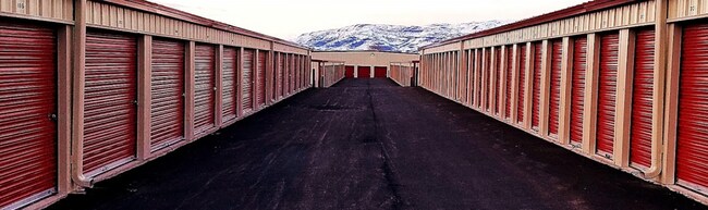

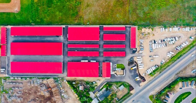
Property Detail
2117 S Highway 40
00-0021-1520
BEGINNING AT A POINT WEST 1320 FEET AND SOUTH 520 FEET FROM THE E CORNER OF SEC 8 T4S R5E SLM: S0-0-15E 398.68; S0-0-5E 413
Commercialnec
Wasatch
B and X Area of moderate flood hazard, usually the area between the limits of the 100-year and 500-year floods.
Utah
2025
9.37 AC
2025
Park City
960201
Other Market Areas
143,656 SF
Heber, UT
NEARBY LISTINGS FOR SALE OR LEASE
-
-
View all Heber City listings for sale on LoopNet.com
DEMOGRAPHICS near 2117 S Highway 40
1 mile
3 mile
5 mile
2025 Total Population
6,102
20,936
28,195
2030 Population
6,417
21,672
29,390
Pop Growth 2025-2030
+ 5.16%
+ 3.52%
+ 4.24%
Average Age
32
34
35
2025 Total Households
1,660
6,072
8,457
HH Growth 2025-2030
+ 5.54%
+ 3.52%
+ 4.28%
Median Household Inc
$93,392
$106,545
$111,298
Avg Household Size
3.50
3.30
3.20
2025 Avg HH Vehicles
3.00
3.00
3.00
Median Home Value
$639,171
$717,110
$751,082
Median Year Built
2010
2007
2007
Nearby Places
Map Layers
Map Styles
 Street
 Aerial
Layers
 Traffic
 Biking
Places
Listings with unknown addresses are not visible on the map
- Restaurants
- Banks
- Shops
- Fitness
- Groceries
PUBLIC TRANSPORTATION
AIRPORT
Provo Municipal
Drive
Walk
Distance
Provo Municipal
43 min
33.2 mi
Freight Ports
Port of Stockton
Drive
Walk
Distance
Port of Stockton
760 min
741.9 mi
SALE & LEASE HISTORY
LISTING DATE
SALE/LEASE

Jan 19, 2024
For Sale
Nearby Properties
Address
Land Use
TOTAL SIZE
Lot Size
Zoning
Address
Land Use
TOTAL SIZE
Lot Size
Zoning
Address
Land Use
TOTAL SIZE
Lot Size
Zoning
135,682 SF
7.58 AC
Address
Land Use
TOTAL SIZE
Lot Size
Zoning
63,773 SF
2.99 AC
Address
Land Use
TOTAL SIZE
Lot Size
Zoning
Address
Land Use
TOTAL SIZE
Lot Size
Zoning
Address
Land Use
TOTAL SIZE
Lot Size
Zoning
83.49 AC
Address
Land Use
TOTAL SIZE
Lot Size
Zoning
75,846 SF
2.71 AC
Address
Land Use
TOTAL SIZE
Lot Size
Zoning
48,894 SF
3.17 AC
Address
Land Use
TOTAL SIZE
Lot Size
Zoning
143,000 SF
9.47 AC
Address
Land Use
TOTAL SIZE
Lot Size
Zoning
34,952 SF
5.34 AC
Address
Land Use
TOTAL SIZE
Lot Size
Zoning
48,360 SF
3.36 AC
Address
Land Use
TOTAL SIZE
Lot Size
Zoning
92,994 SF
14.18 AC
Address
Land Use
TOTAL SIZE
Lot Size
Zoning
59,045 SF
2 AC
Address
Land Use
TOTAL SIZE
Lot Size
Zoning
38,936 SF
3.44 AC
Address
Land Use
TOTAL SIZE
Lot Size
Zoning
2.26 AC
Address
Land Use
TOTAL SIZE
Lot Size
Zoning
90,314 SF
5.83 AC
Address
Land Use
TOTAL SIZE
Lot Size
Zoning
122,800 SF
11.33 AC
Address
Land Use
TOTAL SIZE
Lot Size
Zoning
70,813 SF
5.69 AC
Address
Land Use
TOTAL SIZE
Lot Size
Zoning
69,109 SF
3.76 AC
Address
Land Use
TOTAL SIZE
Lot Size
Zoning
39,566 SF
9.50 AC
Address
Land Use
TOTAL SIZE
Lot Size
Zoning
28,500 SF
2.57 AC
Address
Land Use
TOTAL SIZE
Lot Size
Zoning
37,233 SF
1.72 AC
Address
Land Use
TOTAL SIZE
Lot Size
Zoning
53,404 SF
4.88 AC
Address
Land Use
TOTAL SIZE
Lot Size
Zoning
The World's #1 Commercial Real Estate Marketplace
Connect with us
© 2026 CoStar Group
The information above has been obtained from sources believed reliable. While we do not doubt its accuracy we have not verified it and make no guarantee, warranty or representation about it. It is your responsibility to independently confirm its accuracy and completeness. Any projections, opinions, assumptions, or estimates used are for example only and do not represent the current or future performance of the property. The value of this transaction to you depends on tax and other factors which should be evaluated by your tax, financial, and legal advisors. You and your advisors should conduct a careful, independent investigation of the property to determine to your satisfaction the suitability of the property for your needs.