Property Record
195 Remington Blvd, Bolingbrook, IL 60440


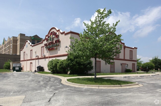
Property Detail
195 Remington Blvd
Chicago-Naperville-Elgin, IL-IN
LOT 5 IN BOLINGBROOK BUSINESS PARK UNIT 7, A SUB OF PRT OF THE SE1/4 OF SEC 15 PRT OF THE NE1/4 OF SEC 22, T37N-R10E.
12-02-15-402-014
Will
Commercialnec
Illinois
B and X Area of moderate flood hazard, usually the area between the limits of the 100-year and 500-year floods.
5
2024
2 AC
2024
Joliet/Central Will
880114
Chicago
7,444 SF
NEARBY LISTINGS FOR SALE OR LEASE
DEMOGRAPHICS near 195 Remington Blvd
1 mile
3 mile
5 mile
2024 Total Population
7,996
61,113
170,499
2029 Population
7,934
61,504
172,218
Pop Growth 2024-2029
(0.78%)
+ 0.64%
+ 1.01%
Average Age
36
39
40
2024 Total Households
2,706
20,214
58,834
HH Growth 2024-2029
(0.59%)
+ 0.73%
+ 1.06%
Median Household Inc
$77,648
$92,635
$108,775
Avg Household Size
2.80
2.90
2.80
2024 Avg HH Vehicles
2.00
2.00
2.00
Median Home Value
$237,701
$270,457
$345,929
Median Year Built
1977
1977
1985
Nearby Places
Map Layers
Map Styles
 Street
 Aerial
Transit
 Traffic
 Biking
Places
Listings with unknown addresses are not visible on the map
- Restaurants
- Banks
- Shops
- Fitness
- Groceries
PUBLIC TRANSPORTATION
COMMUTER RAIL
Drive
Walk
Distance
13 min
5.9 mi
Lemont Station (Heritage Corridor Line - Northeast Illinois Regional Commuter Railroad (Metra))
Drive
Walk
Distance
Lemont Station (Heritage Corridor Line - Northeast Illinois Regional Commuter Railroad (Metra))
13 min
7.6 mi
AIRPORT
Chicago Midway International
Drive
Walk
Distance
Chicago Midway International
28 min
19.6 mi
Chicago O'Hare International
Drive
Walk
Distance
Chicago O'Hare International
45 min
30.9 mi
Nearby Properties
Address
Land Use
TOTAL SIZE
Lot Size
Zoning
Address
Land Use
TOTAL SIZE
Lot Size
Zoning
122.95 AC
Address
Land Use
TOTAL SIZE
Lot Size
Zoning
32.82 AC
Address
Land Use
TOTAL SIZE
Lot Size
Zoning
115.36 AC
Address
Land Use
TOTAL SIZE
Lot Size
Zoning
49.82 AC
Address
Land Use
TOTAL SIZE
Lot Size
Zoning
1,107,073 SF
35.03 AC
Address
Land Use
TOTAL SIZE
Lot Size
Zoning
21,520 SF
32.67 AC
Address
Land Use
TOTAL SIZE
Lot Size
Zoning
373,827 SF
21.30 AC
Address
Land Use
TOTAL SIZE
Lot Size
Zoning
759,709 SF
41.75 AC
Address
Land Use
TOTAL SIZE
Lot Size
Zoning
21.12 AC
Address
Land Use
TOTAL SIZE
Lot Size
Zoning
48.48 AC
Address
Land Use
TOTAL SIZE
Lot Size
Zoning
766,789 SF
52.04 AC
Address
Land Use
TOTAL SIZE
Lot Size
Zoning
22.75 AC
Address
Land Use
TOTAL SIZE
Lot Size
Zoning
49.91 AC
Address
Land Use
TOTAL SIZE
Lot Size
Zoning
751,809 SF
36.59 AC
Address
Land Use
TOTAL SIZE
Lot Size
Zoning
806,164 SF
35.45 AC
Address
Land Use
TOTAL SIZE
Lot Size
Zoning
Address
Land Use
TOTAL SIZE
Lot Size
Zoning
698,727 SF
40.97 AC
Address
Land Use
TOTAL SIZE
Lot Size
Zoning
334,656 SF
17.72 AC
I
Address
Land Use
TOTAL SIZE
Lot Size
Zoning
723,073 SF
37.46 AC
Address
Land Use
TOTAL SIZE
Lot Size
Zoning
652,056 SF
26.43 AC
Address
Land Use
TOTAL SIZE
Lot Size
Zoning
691,629 SF
32.73 AC
Address
Land Use
TOTAL SIZE
Lot Size
Zoning
660,649 SF
29.66 AC
Address
Land Use
TOTAL SIZE
Lot Size
Zoning
28.89 AC
Address
Land Use
TOTAL SIZE
Lot Size
Zoning
604,084 SF
32.65 AC
Address
Land Use
TOTAL SIZE
Lot Size
Zoning
602,328 SF
30.50 AC
Address
Land Use
TOTAL SIZE
Lot Size
Zoning
12.52 AC
Address
Land Use
TOTAL SIZE
Lot Size
Zoning
581,000 SF
28.56 AC
Address
Land Use
TOTAL SIZE
Lot Size
Zoning
270,372 SF
12.49 AC
Address
Land Use
TOTAL SIZE
Lot Size
Zoning
28.15 AC
Address
Land Use
TOTAL SIZE
Lot Size
Zoning
557,851 SF
25.47 AC
The World's #1 Commercial Real Estate Marketplace
Connect with us
© 2026 CoStar Group
The information above has been obtained from sources believed reliable. While we do not doubt its accuracy we have not verified it and make no guarantee, warranty or representation about it. It is your responsibility to independently confirm its accuracy and completeness. Any projections, opinions, assumptions, or estimates used are for example only and do not represent the current or future performance of the property. The value of this transaction to you depends on tax and other factors which should be evaluated by your tax, financial, and legal advisors. You and your advisors should conduct a careful, independent investigation of the property to determine to your satisfaction the suitability of the property for your needs.