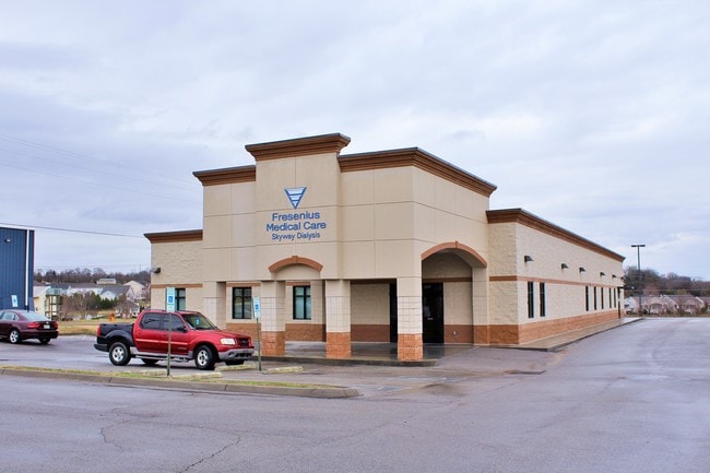
Property Record
783 New Highway 68, Sweetwater, TN 37874

Property Detail
783 New Highway 68
033B-A-003.01
DISTRICT: 01 FRESENIUS MEDICAL CENTER SKYWAY DIALYSIS, COUNTY AREA: A01
Medicalbuilding
Monroe
B and X Area of moderate flood hazard, usually the area between the limits of the 100-year and 500-year floods.
Tennessee
0
1.20 AC
2025
Tennessee East Area
925101
Other Market Areas
9,506 SF
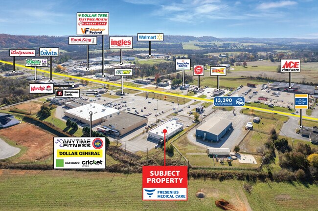
NEARBY LISTINGS FOR SALE OR LEASE
-
-
View all Sweetwater listings for sale on LoopNet.com
DEMOGRAPHICS near 783 New Highway 68
1 mile
3 mile
5 mile
2024 Total Population
2,677
8,642
13,878
2029 Population
2,821
9,113
14,659
Pop Growth 2024-2029
+ 5.38%
+ 5.45%
+ 5.63%
Average Age
42
42
42
2024 Total Households
1,079
3,442
5,483
HH Growth 2024-2029
+ 5.38%
+ 5.55%
+ 5.69%
Median Household Inc
$47,447
$51,356
$56,677
Avg Household Size
2.40
2.40
2.40
2024 Avg HH Vehicles
2.00
2.00
2.00
Median Home Value
$196,232
$176,335
$186,835
Median Year Built
1980
1985
1988
Nearby Places
Map Layers
Map Styles
 Street
 Aerial
Transit
 Traffic
 Biking
Places
Listings with unknown addresses are not visible on the map
- Restaurants
- Banks
- Shops
- Fitness
- Groceries
SALE & LEASE HISTORY
LISTING DATE
SALE/LEASE

Mar 26, 2019
For Sale
Dec 06, 2024
For Sale
Nearby Properties
Address
Land Use
TOTAL SIZE
Lot Size
Zoning
Address
Land Use
TOTAL SIZE
Lot Size
Zoning
714,000 SF
38.08 AC
Address
Land Use
TOTAL SIZE
Lot Size
Zoning
153,877 SF
25.93 AC
Address
Land Use
TOTAL SIZE
Lot Size
Zoning
4,950 SF
9.05 AC
Address
Land Use
TOTAL SIZE
Lot Size
Zoning
72,500 SF
11.96 AC
Address
Land Use
TOTAL SIZE
Lot Size
Zoning
33,288 SF
8.30 AC
R2
Address
Land Use
TOTAL SIZE
Lot Size
Zoning
17,586 SF
Address
Land Use
TOTAL SIZE
Lot Size
Zoning
42,178 SF
2.34 AC
Address
Land Use
TOTAL SIZE
Lot Size
Zoning
170,598 SF
30.44 AC
M2
Address
Land Use
TOTAL SIZE
Lot Size
Zoning
143,475 SF
27.60 AC
Address
Land Use
TOTAL SIZE
Lot Size
Zoning
103,621 SF
11 AC
M2
Address
Land Use
TOTAL SIZE
Lot Size
Zoning
95,224 SF
8.21 AC
C3
Address
Land Use
TOTAL SIZE
Lot Size
Zoning
36,807 SF
2.75 AC
R2
Address
Land Use
TOTAL SIZE
Lot Size
Zoning
28,120 SF
10.90 AC
Address
Land Use
TOTAL SIZE
Lot Size
Zoning
17,540 SF
7 AC
C3
Address
Land Use
TOTAL SIZE
Lot Size
Zoning
91,250 SF
13.04 AC
Address
Land Use
TOTAL SIZE
Lot Size
Zoning
44,485 SF
4.05 AC
Address
Land Use
TOTAL SIZE
Lot Size
Zoning
1,350 SF
32.20 AC
M1
Address
Land Use
TOTAL SIZE
Lot Size
Zoning
15,066 SF
2.27 AC
C3
Address
Land Use
TOTAL SIZE
Lot Size
Zoning
35,752 SF
1.74 AC
C5
Address
Land Use
TOTAL SIZE
Lot Size
Zoning
12,840 SF
4.50 AC
Address
Land Use
TOTAL SIZE
Lot Size
Zoning
11,359 SF
2 AC
C5
Address
Land Use
TOTAL SIZE
Lot Size
Zoning
3,422 SF
16.48 AC
Address
Land Use
TOTAL SIZE
Lot Size
Zoning
28,207 SF
5.10 AC
C3
Address
Land Use
TOTAL SIZE
Lot Size
Zoning
24,513 SF
0.72 AC
C2
Address
Land Use
TOTAL SIZE
Lot Size
Zoning
31,551 SF
1.67 AC
R2
Address
Land Use
TOTAL SIZE
Lot Size
Zoning
30,504 SF
15 AC
M2
Address
Land Use
TOTAL SIZE
Lot Size
Zoning
130,594 SF
7.75 AC
M2
Address
Land Use
TOTAL SIZE
Lot Size
Zoning
146.93 AC
Address
Land Use
TOTAL SIZE
Lot Size
Zoning
139 AC
R2
Address
Land Use
TOTAL SIZE
Lot Size
Zoning
27.60 AC
R1
The World's #1 Commercial Real Estate Marketplace
Connect with us
© 2026 CoStar Group
The information above has been obtained from sources believed reliable. While we do not doubt its accuracy we have not verified it and make no guarantee, warranty or representation about it. It is your responsibility to independently confirm its accuracy and completeness. Any projections, opinions, assumptions, or estimates used are for example only and do not represent the current or future performance of the property. The value of this transaction to you depends on tax and other factors which should be evaluated by your tax, financial, and legal advisors. You and your advisors should conduct a careful, independent investigation of the property to determine to your satisfaction the suitability of the property for your needs.