Property Record
1109 Sunset Dr, East Peoria, IL 61611
Property Detail
1109 Sunset Dr
Peoria, IL
T27N - R4W - S35 TRACT 1 EX TRACT 1-A SW 1/4 SEC 35
07-35-301-024
WOODFORD
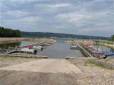
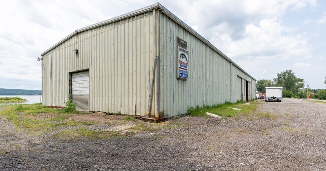
Marinafacility
Illinois
AE The base floodplain where base flood elevations are provided. AE Zones are now used on new format FIRMs instead of A1-A30 Zones.
24.80 AC
2024
Woodford County
2024
Peoria
021202
NEARBY LISTINGS FOR SALE OR LEASE
DEMOGRAPHICS near 1109 Sunset Dr
1 mile
3 mile
5 mile
2025 Total Population
654
15,051
81,359
2030 Population
674
15,082
81,592
Pop Growth 2025-2030
+ 3.06%
+ 0.21%
+ 0.29%
Average Age
44
42
41
2025 Total Households
273
6,712
34,662
HH Growth 2025-2030
+ 3.30%
+ 0.10%
+ 0.29%
Median Household Inc
$84,062
$65,059
$60,311
Avg Household Size
2.40
2.20
2.30
2025 Avg HH Vehicles
2.00
2.00
2.00
Median Home Value
$198,794
$156,865
$153,110
Median Year Built
1989
1958
1961
Nearby Places
Map Layers
Map Styles
 Street
 Aerial
Transit
 Traffic
 Biking
Places
Listings with unknown addresses are not visible on the map
- Restaurants
- Banks
- Shops
- Fitness
- Groceries
PUBLIC TRANSPORTATION
AIRPORT
General Downing - Peoria International
Drive
Walk
Distance
General Downing - Peoria International
25 min
14.8 mi
Freight Ports
Port Milwaukee
Drive
Walk
Distance
Port Milwaukee
264 min
216.6 mi
SALE & LEASE HISTORY
LISTING DATE
SALE/LEASE

Aug 15, 2024
For Sale
Nearby Properties
Address
Land Use
TOTAL SIZE
Lot Size
Zoning
Address
Land Use
TOTAL SIZE
Lot Size
Zoning
322,258 SF
1,319.75 AC
Address
Land Use
TOTAL SIZE
Lot Size
Zoning
5.39 AC
Address
Land Use
TOTAL SIZE
Lot Size
Zoning
80,102 SF
2 AC
Address
Land Use
TOTAL SIZE
Lot Size
Zoning
17.42 AC
Address
Land Use
TOTAL SIZE
Lot Size
Zoning
47,352 SF
Address
Land Use
TOTAL SIZE
Lot Size
Zoning
Address
Land Use
TOTAL SIZE
Lot Size
Zoning
Address
Land Use
TOTAL SIZE
Lot Size
Zoning
114,680 SF
7.34 AC
Address
Land Use
TOTAL SIZE
Lot Size
Zoning
Address
Land Use
TOTAL SIZE
Lot Size
Zoning
26.62 AC
Address
Land Use
TOTAL SIZE
Lot Size
Zoning
66,584 SF
15.23 AC
Address
Land Use
TOTAL SIZE
Lot Size
Zoning
18.67 AC
Address
Land Use
TOTAL SIZE
Lot Size
Zoning
Address
Land Use
TOTAL SIZE
Lot Size
Zoning
Address
Land Use
TOTAL SIZE
Lot Size
Zoning
Address
Land Use
TOTAL SIZE
Lot Size
Zoning
Address
Land Use
TOTAL SIZE
Lot Size
Zoning
Address
Land Use
TOTAL SIZE
Lot Size
Zoning
Address
Land Use
TOTAL SIZE
Lot Size
Zoning
Address
Land Use
TOTAL SIZE
Lot Size
Zoning
36,214 SF
3.68 AC
Address
Land Use
TOTAL SIZE
Lot Size
Zoning
Address
Land Use
TOTAL SIZE
Lot Size
Zoning
7.68 AC
Address
Land Use
TOTAL SIZE
Lot Size
Zoning
Address
Land Use
TOTAL SIZE
Lot Size
Zoning
29.42 AC
Address
Land Use
TOTAL SIZE
Lot Size
Zoning
Address
Land Use
TOTAL SIZE
Lot Size
Zoning
49,000 SF
4.12 AC
Address
Land Use
TOTAL SIZE
Lot Size
Zoning
Address
Land Use
TOTAL SIZE
Lot Size
Zoning
3.62 AC
Address
Land Use
TOTAL SIZE
Lot Size
Zoning
20,000 SF
3 AC
Address
Land Use
TOTAL SIZE
Lot Size
Zoning
20.93 AC
The World's #1 Commercial Real Estate Marketplace
Connect with us
© 2026 CoStar Group
The information above has been obtained from sources believed reliable. While we do not doubt its accuracy we have not verified it and make no guarantee, warranty or representation about it. It is your responsibility to independently confirm its accuracy and completeness. Any projections, opinions, assumptions, or estimates used are for example only and do not represent the current or future performance of the property. The value of this transaction to you depends on tax and other factors which should be evaluated by your tax, financial, and legal advisors. You and your advisors should conduct a careful, independent investigation of the property to determine to your satisfaction the suitability of the property for your needs.