Property Record
181 Port Rd, Kennebunk, ME 04043
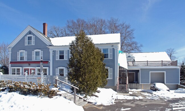
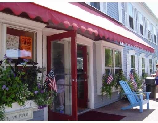
Property Detail
181 Port Rd
KENB-000089-000000-000095
York
Departmentstore
Maine
X
95
23031C0601G
0.39 AC
2024
York County
2024
Portland/South Portland
028004
Portland-South Portland, ME
5,750 SF
NEARBY LISTINGS FOR SALE OR LEASE
DEMOGRAPHICS near 181 Port Rd
1 mile
3 mile
5 mile
2024 Total Population
1,959
7,035
17,035
2029 Population
2,175
7,619
18,427
Pop Growth 2024-2029
+ 11.03%
+ 8.30%
+ 8.17%
Average Age
53
51
51
2024 Total Households
886
3,233
7,788
HH Growth 2024-2029
+ 10.95%
+ 8.23%
+ 8.09%
Median Household Inc
$100,382
$94,180
$84,475
Avg Household Size
2.20
2.20
2.10
2024 Avg HH Vehicles
2.00
2.00
2.00
Median Home Value
$766,467
$632,760
$435,731
Median Year Built
1978
1976
1981
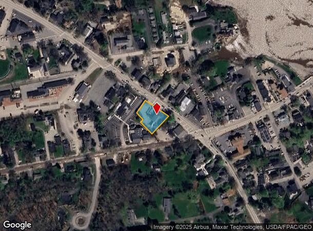
Nearby Places
Map Layers
Map Styles
 Street
 Aerial
Transit
 Traffic
 Biking
Places
Listings with unknown addresses are not visible on the map
- Restaurants
- Banks
- Shops
- Fitness
- Groceries
PUBLIC TRANSPORTATION
COMMUTER RAIL
Drive
Walk
Distance
17 min
7.9 mi
AIRPORT
Portland International Jetport
Drive
Walk
Distance
Portland International Jetport
38 min
27.4 mi
Portsmouth International at Pease
Drive
Walk
Distance
Portsmouth International at Pease
46 min
30.4 mi
Nearby Properties
Address
Land Use
TOTAL SIZE
Lot Size
Zoning
Address
Land Use
TOTAL SIZE
Lot Size
Zoning
10,638 SF
14.70 AC
VRE
Address
Land Use
TOTAL SIZE
Lot Size
Zoning
11,010 SF
1.44 AC
CA
Address
Land Use
TOTAL SIZE
Lot Size
Zoning
6.40 AC
CA
Address
Land Use
TOTAL SIZE
Lot Size
Zoning
7 AC
RF
Address
Land Use
TOTAL SIZE
Lot Size
Zoning
7,521 SF
1.60 AC
CA
Address
Land Use
TOTAL SIZE
Lot Size
Zoning
3.33 AC
RF
Address
Land Use
TOTAL SIZE
Lot Size
Zoning
63,224 SF
37.60 AC
7
Address
Land Use
TOTAL SIZE
Lot Size
Zoning
5,923 SF
2.52 AC
VRE
Address
Land Use
TOTAL SIZE
Lot Size
Zoning
0.76 AC
Address
Land Use
TOTAL SIZE
Lot Size
Zoning
4.20 AC
VR
Address
Land Use
TOTAL SIZE
Lot Size
Zoning
8,268 SF
0.60 AC
CA
Address
Land Use
TOTAL SIZE
Lot Size
Zoning
7,260 SF
0.84 AC
CA
Address
Land Use
TOTAL SIZE
Lot Size
Zoning
6,415 SF
0.52 AC
CA
Address
Land Use
TOTAL SIZE
Lot Size
Zoning
9,016 SF
1.30 AC
CA
Address
Land Use
TOTAL SIZE
Lot Size
Zoning
1.50 AC
CA
Address
Land Use
TOTAL SIZE
Lot Size
Zoning
6,138 SF
0.69 AC
CA
Address
Land Use
TOTAL SIZE
Lot Size
Zoning
5,376 SF
1.30 AC
CA
Address
Land Use
TOTAL SIZE
Lot Size
Zoning
4,873 SF
0.79 AC
CA
Address
Land Use
TOTAL SIZE
Lot Size
Zoning
4,394 SF
0.75 AC
CA
Address
Land Use
TOTAL SIZE
Lot Size
Zoning
7,478 SF
1.20 AC
CA
Address
Land Use
TOTAL SIZE
Lot Size
Zoning
4,850 SF
0.95 AC
CA
Address
Land Use
TOTAL SIZE
Lot Size
Zoning
3,182 SF
1.20 AC
CA
Address
Land Use
TOTAL SIZE
Lot Size
Zoning
5,797 SF
1.10 AC
CA
Address
Land Use
TOTAL SIZE
Lot Size
Zoning
4,215 SF
1.10 AC
CA
Address
Land Use
TOTAL SIZE
Lot Size
Zoning
6,836 SF
1.57 AC
CA
Address
Land Use
TOTAL SIZE
Lot Size
Zoning
1.31 AC
CA
Address
Land Use
TOTAL SIZE
Lot Size
Zoning
8,427 SF
0.56 AC
CA
Address
Land Use
TOTAL SIZE
Lot Size
Zoning
6,181 SF
0.88 AC
CA
Address
Land Use
TOTAL SIZE
Lot Size
Zoning
28,227 SF
3.54 AC
RF
Address
Land Use
TOTAL SIZE
Lot Size
Zoning
6,107 SF
0.68 AC
CA
The World's #1 Commercial Real Estate Marketplace
Connect with us
© 2026 CoStar Group
The information above has been obtained from sources believed reliable. While we do not doubt its accuracy we have not verified it and make no guarantee, warranty or representation about it. It is your responsibility to independently confirm its accuracy and completeness. Any projections, opinions, assumptions, or estimates used are for example only and do not represent the current or future performance of the property. The value of this transaction to you depends on tax and other factors which should be evaluated by your tax, financial, and legal advisors. You and your advisors should conduct a careful, independent investigation of the property to determine to your satisfaction the suitability of the property for your needs.