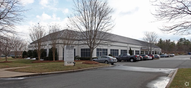
Property Record
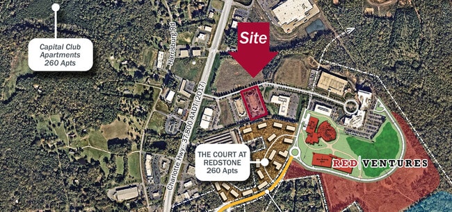
1061 Red Ventures Dr, Fort Mill, SC 29707

NEARBY LISTINGS FOR SALE OR LEASE
Property Detail
1061 Red Ventures Dr
0005-00-103.00
Lancaster
Commercialnec
South Carolina
X
1
45057C0040E
6.37 AC
2024
Lancaster County
2024
Charlotte
011206
Charlotte-Concord-Gastonia, NC-SC
66,418 SF
DEMOGRAPHICS near 1061 Red Ventures Dr
1 Mile
3 Mile
5 Mile
2024 Total Population
4,229
54,753
137,071
2029 Population
5,256
61,386
151,908
Pop Growth 2024-2029
+ 24.28%
+ 12.11%
+ 10.82%
Average Age
40
38
39
2024 Total Households
1,658
19,420
50,185
HH Growth 2024-2029
+ 24.67%
+ 12.40%
+ 10.88%
Median Household Inc
$100,781
$128,571
$120,476
Avg Household Size
2.50
2.80
2.70
2024 Avg HH Vehicles
2.00
2.00
2.00
Median Home Value
$256,318
$436,126
$417,946
Median Year Built
2010
2006
2004
Nearby Places
Map Layers
Map Styles
 Street
 Aerial
- Restaurants
- Banks
- Shops
- Fitness
- Groceries
PUBLIC TRANSPORTATION
AIRPORT
Charlotte/Douglas International
DRIVE
WALK
Distance
Charlotte/Douglas International
30 min
18.0 mi
Concord-Padgett Regional
DRIVE
WALK
Distance
Concord-Padgett Regional
49 min
39.2 mi
SALE & LEASE HISTORY
LISTING DATE
SALE/LEASE

Sep 16, 2021
For Lease
Nearby Properties
Address
Land Use
TOTAL SIZE
Lot Size
Zoning
Address
Land Use
TOTAL SIZE
Lot Size
Zoning
294,279 SF
27.77 AC
R12MFCD
Address
Land Use
TOTAL SIZE
Lot Size
Zoning
215,600 SF
6.97 AC
R3
Address
Land Use
TOTAL SIZE
Lot Size
Zoning
348,409 SF
26.08 AC
R17MFCD
Address
Land Use
TOTAL SIZE
Lot Size
Zoning
287,004 SF
14.52 AC
R3
Address
Land Use
TOTAL SIZE
Lot Size
Zoning
353,996 SF
58.49 AC
R3
Address
Land Use
TOTAL SIZE
Lot Size
Zoning
195,262 SF
4.56 AC
Address
Land Use
TOTAL SIZE
Lot Size
Zoning
201,638 SF
7.44 AC
R-12PUD
Address
Land Use
TOTAL SIZE
Lot Size
Zoning
254,527 SF
9.34 AC
MX2
Address
Land Use
TOTAL SIZE
Lot Size
Zoning
234,912 SF
11.60 AC
R3
Address
Land Use
TOTAL SIZE
Lot Size
Zoning
211,609 SF
6.91 AC
UR2CD
Address
Land Use
TOTAL SIZE
Lot Size
Zoning
182,180 SF
7.31 AC
MX2
Address
Land Use
TOTAL SIZE
Lot Size
Zoning
160,395 SF
34.25 AC
R3
Address
Land Use
TOTAL SIZE
Lot Size
Zoning
137,210 SF
4.52 AC
Address
Land Use
TOTAL SIZE
Lot Size
Zoning
90,466 SF
105.72 AC
INST
Address
Land Use
TOTAL SIZE
Lot Size
Zoning
98,222 SF
2.84 AC
Address
Land Use
TOTAL SIZE
Lot Size
Zoning
120,698 SF
5.18 AC
Address
Land Use
TOTAL SIZE
Lot Size
Zoning
74,000 SF
20.51 AC
O-1(CD)
Address
Land Use
TOTAL SIZE
Lot Size
Zoning
121,180 SF
20.23 AC
INST
Address
Land Use
TOTAL SIZE
Lot Size
Zoning
86,368 SF
11.28 AC
NS
Address
Land Use
TOTAL SIZE
Lot Size
Zoning
133,155 SF
5.57 AC
I-1(CD)
Address
Land Use
TOTAL SIZE
Lot Size
Zoning
3,948 SF
14.70 AC
MUDD-O
Address
Land Use
TOTAL SIZE
Lot Size
Zoning
74,604 SF
2.26 AC
Address
Land Use
TOTAL SIZE
Lot Size
Zoning
77,646 SF
13.89 AC
Address
Land Use
TOTAL SIZE
Lot Size
Zoning
53,352 SF
17.65 AC
INST
Address
Land Use
TOTAL SIZE
Lot Size
Zoning
86,655 SF
17.61 AC
R-12PUD
Address
Land Use
TOTAL SIZE
Lot Size
Zoning
228.10 AC
MX-1(INNOV
Address
Land Use
TOTAL SIZE
Lot Size
Zoning
80,614 SF
6.83 AC
MX-2
Address
Land Use
TOTAL SIZE
Lot Size
Zoning
93,956 SF
21.28 AC
R-40 MARVI
Address
Land Use
TOTAL SIZE
Lot Size
Zoning
108,195 SF
28.29 AC
INS
Address
Land Use
TOTAL SIZE
Lot Size
Zoning
66,102 SF
2.42 AC
CC
The World's #1 Commercial Real Estate Marketplace
Connect with us
© 2025 CoStar Group
The information above has been obtained from sources believed reliable. While we do not doubt its accuracy we have not verified it and make no guarantee, warranty or representation about it. It is your responsibility to independently confirm its accuracy and completeness. Any projections, opinions, assumptions, or estimates used are for example only and do not represent the current or future performance of the property. The value of this transaction to you depends on tax and other factors which should be evaluated by your tax, financial, and legal advisors. You and your advisors should conduct a careful, independent investigation of the property to determine to your satisfaction the suitability of the property for your needs.