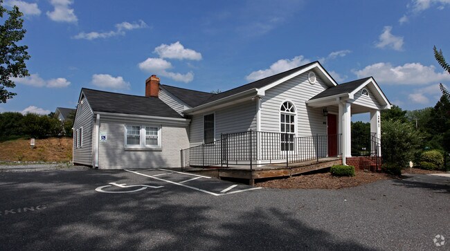
Property Record
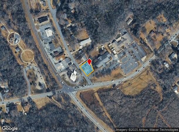
241 Lenmore Dr Se, Concord, NC 28025


NEARBY LISTINGS FOR SALE OR LEASE
Property Detail
241 Lenmore Dr Se
Charlotte-Concord-Gastonia, NC-SC
Branchview Commercial
5630-38-0118-0000
LT 2 GROVE PARK
Officebuilding
Cabarrus
X
North Carolina
3710563000K
2
2025
0.32 AC
2025
Cabarrus County
042300
Charlotte
2,660 SF
DEMOGRAPHICS near 241 Lenmore Dr Se
1 Mile
3 Mile
5 Mile
2024 Total Population
6,284
38,954
87,547
2029 Population
7,105
44,024
98,810
Pop Growth 2024-2029
+ 13.06%
+ 13.02%
+ 12.87%
Average Age
39
39
38
2024 Total Households
2,333
14,731
32,577
HH Growth 2024-2029
+ 11.74%
+ 11.57%
+ 11.44%
Median Household Inc
$65,230
$56,764
$65,255
Avg Household Size
2.40
2.50
2.60
2024 Avg HH Vehicles
2.00
2.00
2.00
Median Home Value
$251,367
$197,943
$233,034
Median Year Built
1958
1973
1989
Nearby Places
Map Layers
Map Styles
 Street
 Aerial
- Restaurants
- Banks
- Shops
- Fitness
- Groceries
PUBLIC TRANSPORTATION
COMMUTER RAIL
Kannapolis Station (Piedmont - North Carolina by Train (NC Train))
DRIVE
WALK
Distance
Kannapolis Station (Piedmont - North Carolina by Train (NC Train))
14 min
7.9 mi
AIRPORT
Concord-Padgett Regional
DRIVE
WALK
Distance
Concord-Padgett Regional
23 min
13.4 mi
Charlotte/Douglas International
DRIVE
WALK
Distance
Charlotte/Douglas International
50 min
33.7 mi
Nearby Properties
Address
Land Use
TOTAL SIZE
Lot Size
Zoning
Address
Land Use
TOTAL SIZE
Lot Size
Zoning
280,149 SF
54.88 AC
C-2
Address
Land Use
TOTAL SIZE
Lot Size
Zoning
162,854 SF
2.11 AC
CC
Address
Land Use
TOTAL SIZE
Lot Size
Zoning
103,849 SF
3.03 AC
CC
Address
Land Use
TOTAL SIZE
Lot Size
Zoning
16,216 SF
24.13 AC
RC
Address
Land Use
TOTAL SIZE
Lot Size
Zoning
32,872 SF
0.90 AC
CC
Address
Land Use
TOTAL SIZE
Lot Size
Zoning
122,102 SF
4.69 AC
CC
Address
Land Use
TOTAL SIZE
Lot Size
Zoning
204,636 SF
109.77 AC
RM-1
Address
Land Use
TOTAL SIZE
Lot Size
Zoning
173,459 SF
15.03 AC
O-I
Address
Land Use
TOTAL SIZE
Lot Size
Zoning
161,202 SF
2.68 AC
CC
Address
Land Use
TOTAL SIZE
Lot Size
Zoning
15,215 SF
30.18 AC
RM-2
Address
Land Use
TOTAL SIZE
Lot Size
Zoning
19,673 SF
26.67 AC
RC
Address
Land Use
TOTAL SIZE
Lot Size
Zoning
90,350 SF
10.20 AC
PID
Address
Land Use
TOTAL SIZE
Lot Size
Zoning
199,363 SF
53.36 AC
I-1
Address
Land Use
TOTAL SIZE
Lot Size
Zoning
94,924 SF
0.39 AC
CC
Address
Land Use
TOTAL SIZE
Lot Size
Zoning
284,429 SF
48.08 AC
PUD
Address
Land Use
TOTAL SIZE
Lot Size
Zoning
13,824 SF
9.78 AC
RC
Address
Land Use
TOTAL SIZE
Lot Size
Zoning
117,919 SF
61.62 AC
RM-1
Address
Land Use
TOTAL SIZE
Lot Size
Zoning
18,288 SF
9.45 AC
RC
Address
Land Use
TOTAL SIZE
Lot Size
Zoning
76,336 SF
0.55 AC
CC
Address
Land Use
TOTAL SIZE
Lot Size
Zoning
30,170 SF
0.80 AC
CC
Address
Land Use
TOTAL SIZE
Lot Size
Zoning
7,000 SF
72.56 AC
I-2
Address
Land Use
TOTAL SIZE
Lot Size
Zoning
119,676 SF
38.58 AC
C-2
Address
Land Use
TOTAL SIZE
Lot Size
Zoning
106,777 SF
4.48 AC
C-1
Address
Land Use
TOTAL SIZE
Lot Size
Zoning
10,072 SF
12.03 AC
RC
Address
Land Use
TOTAL SIZE
Lot Size
Zoning
29,496 SF
9.34 AC
C-2
Address
Land Use
TOTAL SIZE
Lot Size
Zoning
69,251 SF
0.62 AC
CC
Address
Land Use
TOTAL SIZE
Lot Size
Zoning
87,600 SF
0.60 AC
PID
Address
Land Use
TOTAL SIZE
Lot Size
Zoning
59,300 SF
4.54 AC
C-2
Address
Land Use
TOTAL SIZE
Lot Size
Zoning
7,584 SF
12.63 AC
RC
Address
Land Use
TOTAL SIZE
Lot Size
Zoning
57,478 SF
3.70 AC
C-2
The World's #1 Commercial Real Estate Marketplace
Connect with us
© 2025 CoStar Group
The information above has been obtained from sources believed reliable. While we do not doubt its accuracy we have not verified it and make no guarantee, warranty or representation about it. It is your responsibility to independently confirm its accuracy and completeness. Any projections, opinions, assumptions, or estimates used are for example only and do not represent the current or future performance of the property. The value of this transaction to you depends on tax and other factors which should be evaluated by your tax, financial, and legal advisors. You and your advisors should conduct a careful, independent investigation of the property to determine to your satisfaction the suitability of the property for your needs.