Property Record
4332 W County Road 54G, Laporte, CO 80535
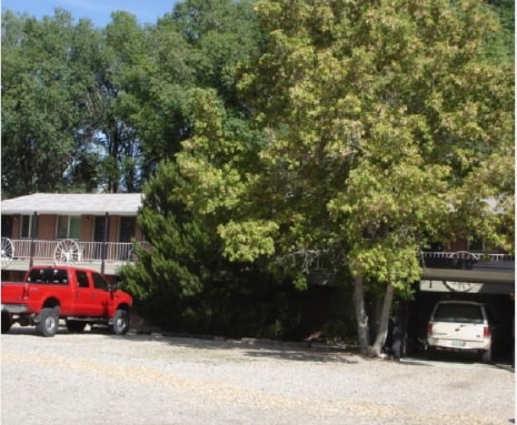

Property Detail
4332 W County Road 54G
98301-00-014
PT S 1/2 OF NE 30-8-69 DESC AS BEG AT A PT S 39 11 30 W 2402.51 FT FROM NE COR, S 89 8 E 457.44 FT, N 0 15 W 246.89 FT, N 89 8 W 591.57 FT TO PT ON ERLY R/W HWY 287, S 24 18 E 4.5 FT TO BEG CUR L, L/C S 28 34 30 E 276.78 FT TO BEG, 3 AC M/L (C11N0
Multifamilydwelling
Larimer
O
Colorado
B and X Area of moderate flood hazard, usually the area between the limits of the 100-year and 500-year floods.
2.97 AC
2024
Fort Collins
2025
Denver
001301
Fort Collins-Loveland, CO
5,390 SF
NEARBY LISTINGS FOR SALE OR LEASE
-
-
View all Laporte listings for sale on LoopNet.com
DEMOGRAPHICS near 4332 W County Road 54G
1 mile
3 mile
5 mile
2024 Total Population
1,084
5,226
32,050
2029 Population
1,059
5,303
32,889
Pop Growth 2024-2029
(2.31%)
+ 1.47%
+ 2.62%
Average Age
45
44
38
2024 Total Households
464
2,234
13,448
HH Growth 2024-2029
(2.37%)
+ 1.48%
+ 2.76%
Median Household Inc
$68,912
$87,892
$72,174
Avg Household Size
2.30
2.30
2.30
2024 Avg HH Vehicles
2.00
2.00
2.00
Median Home Value
$458,552
$591,463
$593,294
Median Year Built
1974
1978
1978
Nearby Places
Map Layers
Map Styles
 Street
 Aerial
Transit
 Traffic
 Biking
Places
Listings with unknown addresses are not visible on the map
- Restaurants
- Banks
- Shops
- Fitness
- Groceries
SALE & LEASE HISTORY
LISTING DATE
SALE/LEASE

Sep 26, 2023
For Sale
Nearby Properties
Address
Land Use
TOTAL SIZE
Lot Size
Zoning
Address
Land Use
TOTAL SIZE
Lot Size
Zoning
111,960 SF
16.50 AC
O
Address
Land Use
TOTAL SIZE
Lot Size
Zoning
110 AC
O
Address
Land Use
TOTAL SIZE
Lot Size
Zoning
114,180 SF
62.50 AC
Address
Land Use
TOTAL SIZE
Lot Size
Zoning
60,000 SF
26.47 AC
O
Address
Land Use
TOTAL SIZE
Lot Size
Zoning
30,000 SF
50.91 AC
FA1
Address
Land Use
TOTAL SIZE
Lot Size
Zoning
25.27 AC
FA
Address
Land Use
TOTAL SIZE
Lot Size
Zoning
27,160 SF
10.40 AC
I
Address
Land Use
TOTAL SIZE
Lot Size
Zoning
17,480 SF
30.86 AC
FA
Address
Land Use
TOTAL SIZE
Lot Size
Zoning
3,400 SF
189.89 AC
FA1
Address
Land Use
TOTAL SIZE
Lot Size
Zoning
24,045 SF
2.38 AC
B
Address
Land Use
TOTAL SIZE
Lot Size
Zoning
21,600 SF
1 AC
C
Address
Land Use
TOTAL SIZE
Lot Size
Zoning
3,400 SF
27.42 AC
O
Address
Land Use
TOTAL SIZE
Lot Size
Zoning
61,364 SF
294.61 AC
O
Address
Land Use
TOTAL SIZE
Lot Size
Zoning
23,500 SF
1.49 AC
PD
Address
Land Use
TOTAL SIZE
Lot Size
Zoning
13,200 SF
14.88 AC
O
Address
Land Use
TOTAL SIZE
Lot Size
Zoning
10,515 SF
35.30 AC
FA
Address
Land Use
TOTAL SIZE
Lot Size
Zoning
61,919 SF
29.37 AC
O
Address
Land Use
TOTAL SIZE
Lot Size
Zoning
12,000 SF
1.75 AC
C
Address
Land Use
TOTAL SIZE
Lot Size
Zoning
1,536 SF
1 AC
O
Address
Land Use
TOTAL SIZE
Lot Size
Zoning
10,242 SF
4.99 AC
O
Address
Land Use
TOTAL SIZE
Lot Size
Zoning
5,328 SF
108.25 AC
FA
Address
Land Use
TOTAL SIZE
Lot Size
Zoning
29,184 SF
2.94 AC
M
Address
Land Use
TOTAL SIZE
Lot Size
Zoning
78,614 SF
9.17 AC
FA1
Address
Land Use
TOTAL SIZE
Lot Size
Zoning
2,128 SF
0.31 AC
B
Address
Land Use
TOTAL SIZE
Lot Size
Zoning
5,640 SF
2.75 AC
O
Address
Land Use
TOTAL SIZE
Lot Size
Zoning
9,048 SF
1.25 AC
PD
Address
Land Use
TOTAL SIZE
Lot Size
Zoning
6,196 SF
0.56 AC
Address
Land Use
TOTAL SIZE
Lot Size
Zoning
3,457 SF
4.92 AC
FA
Address
Land Use
TOTAL SIZE
Lot Size
Zoning
4,470 SF
19.55 AC
O
Address
Land Use
TOTAL SIZE
Lot Size
Zoning
12,000 SF
15.69 AC
O
The World's #1 Commercial Real Estate Marketplace
Connect with us
© 2026 CoStar Group
The information above has been obtained from sources believed reliable. While we do not doubt its accuracy we have not verified it and make no guarantee, warranty or representation about it. It is your responsibility to independently confirm its accuracy and completeness. Any projections, opinions, assumptions, or estimates used are for example only and do not represent the current or future performance of the property. The value of this transaction to you depends on tax and other factors which should be evaluated by your tax, financial, and legal advisors. You and your advisors should conduct a careful, independent investigation of the property to determine to your satisfaction the suitability of the property for your needs.