Property Record
703 N Pearl St, Menands, NY 12204
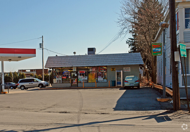

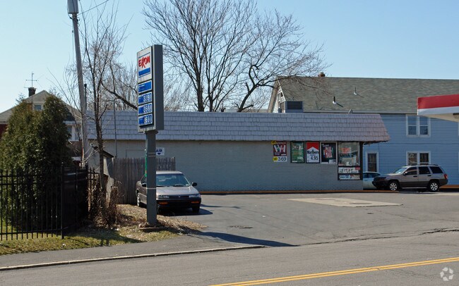
Property Detail
703 N Pearl St
012603-066-005-0003-001-000-0000
LOT 14-15 N-WOLFERT AV E-4 N-25-08
Servicestationmarket
Albany
85
New York
B and X Area of moderate flood hazard, usually the area between the limits of the 100-year and 500-year floods.
1.000
2025
0.20 AC
2025
E Outer Albany County
013602
Albany/Schenectady/Troy
2,000 SF
Albany-Schenectady-Troy, NY
NEARBY LISTINGS FOR SALE OR LEASE
DEMOGRAPHICS near 703 N Pearl St
1 mile
3 mile
5 mile
2024 Total Population
6,386
91,063
210,833
2029 Population
6,536
91,927
212,095
Pop Growth 2024-2029
+ 2.35%
+ 0.95%
+ 0.60%
Average Age
39
37
39
2024 Total Households
2,822
40,052
89,967
HH Growth 2024-2029
+ 2.52%
+ 1.05%
+ 0.70%
Median Household Inc
$69,127
$61,183
$72,351
Avg Household Size
2.20
2.10
2.10
2024 Avg HH Vehicles
1.00
1.00
1.00
Median Home Value
$304,514
$260,536
$259,843
Median Year Built
1972
1954
1956
Nearby Places
Map Layers
Map Styles
 Street
 Aerial
Transit
 Traffic
 Biking
Places
Listings with unknown addresses are not visible on the map
- Restaurants
- Banks
- Shops
- Fitness
- Groceries
PUBLIC TRANSPORTATION
COMMUTER RAIL
Drive
Walk
Distance
10 min
3.6 mi
AIRPORT
Albany International
Drive
Walk
Distance
Albany International
16 min
8.3 mi
Freight Ports
Albany, NY Port
Drive
Walk
Distance
Albany, NY Port
10 min
4.0 mi
Nearby Properties
Address
Land Use
TOTAL SIZE
Lot Size
Zoning
Address
Land Use
TOTAL SIZE
Lot Size
Zoning
901,573 SF
38 AC
CO
Address
Land Use
TOTAL SIZE
Lot Size
Zoning
11,372 SF
30 AC
CO
Address
Land Use
TOTAL SIZE
Lot Size
Zoning
674,048 SF
7.40 AC
CO
Address
Land Use
TOTAL SIZE
Lot Size
Zoning
599,952 SF
28.30 AC
CO
Address
Land Use
TOTAL SIZE
Lot Size
Zoning
442,188 SF
15.10 AC
CO
Address
Land Use
TOTAL SIZE
Lot Size
Zoning
567,019 SF
1.42 AC
CO
Address
Land Use
TOTAL SIZE
Lot Size
Zoning
18,340 SF
159.67 AC
04 - FARM
Address
Land Use
TOTAL SIZE
Lot Size
Zoning
1.42 AC
C3
Address
Land Use
TOTAL SIZE
Lot Size
Zoning
368,685 SF
3.10 AC
CO
Address
Land Use
TOTAL SIZE
Lot Size
Zoning
152,951 SF
3.70 AC
CO
Address
Land Use
TOTAL SIZE
Lot Size
Zoning
197,169 SF
5 AC
CO
Address
Land Use
TOTAL SIZE
Lot Size
Zoning
120,579 SF
49.20 AC
CI
Address
Land Use
TOTAL SIZE
Lot Size
Zoning
358,360 SF
10.10 AC
CO
Address
Land Use
TOTAL SIZE
Lot Size
Zoning
206.10 AC
C2
Address
Land Use
TOTAL SIZE
Lot Size
Zoning
541,564 SF
7.40 AC
C3
Address
Land Use
TOTAL SIZE
Lot Size
Zoning
207.50 AC
CM
Address
Land Use
TOTAL SIZE
Lot Size
Zoning
802,560 SF
5.70 AC
R4
Address
Land Use
TOTAL SIZE
Lot Size
Zoning
326,350 SF
11.11 AC
I
Address
Land Use
TOTAL SIZE
Lot Size
Zoning
156,056 SF
1.31 AC
CO
Address
Land Use
TOTAL SIZE
Lot Size
Zoning
177,030 SF
0.06 AC
C3
Address
Land Use
TOTAL SIZE
Lot Size
Zoning
199,495 SF
5.40 AC
CO
Address
Land Use
TOTAL SIZE
Lot Size
Zoning
889,560 SF
0.50 AC
CO
Address
Land Use
TOTAL SIZE
Lot Size
Zoning
166,812 SF
0.78 AC
CO
Address
Land Use
TOTAL SIZE
Lot Size
Zoning
428,555 SF
1.20 AC
C3
Address
Land Use
TOTAL SIZE
Lot Size
Zoning
11,900 SF
28.60 AC
86
Address
Land Use
TOTAL SIZE
Lot Size
Zoning
105.28 AC
C2
Address
Land Use
TOTAL SIZE
Lot Size
Zoning
99,300 SF
4.66 AC
R2B
Address
Land Use
TOTAL SIZE
Lot Size
Zoning
211,848 SF
27.20 AC
R2A
Address
Land Use
TOTAL SIZE
Lot Size
Zoning
198,884 SF
5.35 AC
CO
Address
Land Use
TOTAL SIZE
Lot Size
Zoning
556,800 SF
0.39 AC
CM
The World's #1 Commercial Real Estate Marketplace
Connect with us
© 2026 CoStar Group
The information above has been obtained from sources believed reliable. While we do not doubt its accuracy we have not verified it and make no guarantee, warranty or representation about it. It is your responsibility to independently confirm its accuracy and completeness. Any projections, opinions, assumptions, or estimates used are for example only and do not represent the current or future performance of the property. The value of this transaction to you depends on tax and other factors which should be evaluated by your tax, financial, and legal advisors. You and your advisors should conduct a careful, independent investigation of the property to determine to your satisfaction the suitability of the property for your needs.