Property Record
1100 Douglas Blvd, Roseville, CA 95678
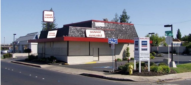


Property Detail
1100 Douglas Blvd
014-130-052
FR SEC 12 10 6
Restaurantdrivein
Placer
B and X Area of moderate flood hazard, usually the area between the limits of the 100-year and 500-year floods.
California
2024
0.46 AC
2025
Roseville/Rocklin
020806
Sacramento
2,428 SF
Sacramento-Roseville-Folsom, CA
NEARBY LISTINGS FOR SALE OR LEASE
DEMOGRAPHICS near 1100 Douglas Blvd
1 mile
3 mile
5 mile
2025 Total Population
13,688
111,010
295,182
2030 Population
14,246
114,546
304,119
Pop Growth 2025-2030
+ 4.08%
+ 3.19%
+ 3.03%
Average Age
43
41
41
2025 Total Households
5,707
43,128
110,456
HH Growth 2025-2030
+ 4.22%
+ 3.27%
+ 3.06%
Median Household Inc
$78,259
$95,639
$99,455
Avg Household Size
2.30
2.50
2.60
2025 Avg HH Vehicles
2.00
2.00
2.00
Median Home Value
$482,291
$599,284
$623,801
Median Year Built
1970
1985
1988
Nearby Places
Map Layers
Map Styles
 Street
 Aerial
Layers
 Traffic
 Biking
Places
Listings with unknown addresses are not visible on the map
- Restaurants
- Banks
- Shops
- Fitness
- Groceries
PUBLIC TRANSPORTATION
COMMUTER RAIL
Drive
Walk
Distance
5 min
20 min
1.0 mi
Drive
Walk
Distance
8 min
4.4 mi
AIRPORT
Sacramento International
Drive
Walk
Distance
Sacramento International
33 min
24.6 mi
Nearby Properties
Address
Land Use
TOTAL SIZE
Lot Size
Zoning
Address
Land Use
TOTAL SIZE
Lot Size
Zoning
1,444,630 SF
53.20 AC
Address
Land Use
TOTAL SIZE
Lot Size
Zoning
678,494 SF
15.80 AC
Address
Land Use
TOTAL SIZE
Lot Size
Zoning
350,573 SF
26.30 AC
Address
Land Use
TOTAL SIZE
Lot Size
Zoning
638,040 SF
38.70 AC
Address
Land Use
TOTAL SIZE
Lot Size
Zoning
277,602 SF
26.49 AC
Address
Land Use
TOTAL SIZE
Lot Size
Zoning
210,380 SF
14.26 AC
Address
Land Use
TOTAL SIZE
Lot Size
Zoning
280,129 SF
14.90 AC
Address
Land Use
TOTAL SIZE
Lot Size
Zoning
325,462 SF
29.50 AC
Address
Land Use
TOTAL SIZE
Lot Size
Zoning
328,416 SF
17.80 AC
Address
Land Use
TOTAL SIZE
Lot Size
Zoning
105,730 SF
7.20 AC
Address
Land Use
TOTAL SIZE
Lot Size
Zoning
174,840 SF
19.70 AC
Address
Land Use
TOTAL SIZE
Lot Size
Zoning
222,702 SF
10.57 AC
Address
Land Use
TOTAL SIZE
Lot Size
Zoning
223,623 SF
12.70 AC
Address
Land Use
TOTAL SIZE
Lot Size
Zoning
132,784 SF
9.80 AC
Address
Land Use
TOTAL SIZE
Lot Size
Zoning
233,228 SF
12.10 AC
Address
Land Use
TOTAL SIZE
Lot Size
Zoning
28,798 SF
12.52 AC
Address
Land Use
TOTAL SIZE
Lot Size
Zoning
288,628 SF
11.90 AC
Address
Land Use
TOTAL SIZE
Lot Size
Zoning
143,809 SF
14.40 AC
Address
Land Use
TOTAL SIZE
Lot Size
Zoning
263,682 SF
14.40 AC
Address
Land Use
TOTAL SIZE
Lot Size
Zoning
120,983 SF
17.60 AC
Address
Land Use
TOTAL SIZE
Lot Size
Zoning
718,131 SF
42 AC
Address
Land Use
TOTAL SIZE
Lot Size
Zoning
121,000 SF
17.20 AC
Address
Land Use
TOTAL SIZE
Lot Size
Zoning
188,500 SF
20.30 AC
Address
Land Use
TOTAL SIZE
Lot Size
Zoning
142,063 SF
8.70 AC
Address
Land Use
TOTAL SIZE
Lot Size
Zoning
78,730 SF
8.03 AC
RD20 BP
Address
Land Use
TOTAL SIZE
Lot Size
Zoning
82,661 SF
7.50 AC
Address
Land Use
TOTAL SIZE
Lot Size
Zoning
128,480 SF
7.95 AC
RD30 BP
Address
Land Use
TOTAL SIZE
Lot Size
Zoning
220,000 SF
10 AC
Address
Land Use
TOTAL SIZE
Lot Size
Zoning
119,417 SF
11 AC
Address
Land Use
TOTAL SIZE
Lot Size
Zoning
2,080 SF
136.17 AC
FDR
The World's #1 Commercial Real Estate Marketplace
Connect with us
© 2026 CoStar Group
The information above has been obtained from sources believed reliable. While we do not doubt its accuracy we have not verified it and make no guarantee, warranty or representation about it. It is your responsibility to independently confirm its accuracy and completeness. Any projections, opinions, assumptions, or estimates used are for example only and do not represent the current or future performance of the property. The value of this transaction to you depends on tax and other factors which should be evaluated by your tax, financial, and legal advisors. You and your advisors should conduct a careful, independent investigation of the property to determine to your satisfaction the suitability of the property for your needs.