Property Record
3610 County Road 101 S, Wayzata, MN 55391
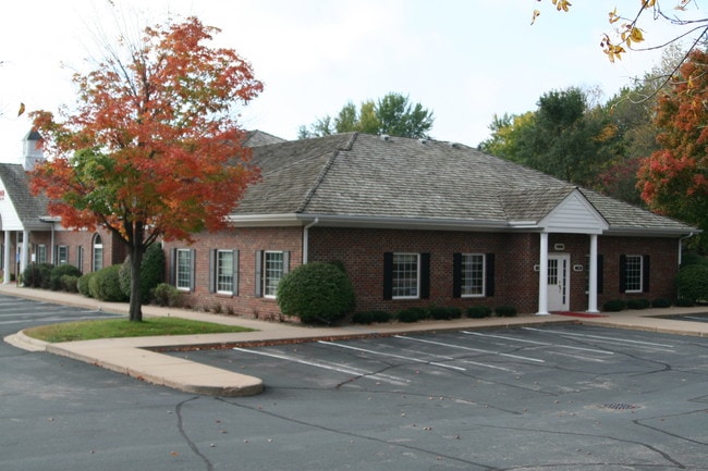
Property Detail
3610 County Road 101 S
Minneapolis-St. Paul-Bloomington, MN-WI
LOT 048 T MINNETONKA GROVELAND PARK INCL ADJ 1/2 OF ST VAC SUBJECT TO HWY IRREGULAR
18-117-22-44-0042
Hennepin
Commercialnec
Minnesota
B and X Area of moderate flood hazard, usually the area between the limits of the 100-year and 500-year floods.
48
2024
0.73 AC
2024
I-394 Corridor
027400
Minneapolis/St Paul
NEARBY LISTINGS FOR SALE OR LEASE
DEMOGRAPHICS near 3610 County Road 101 S
1 mile
3 mile
5 mile
2025 Total Population
5,781
36,318
121,261
2030 Population
5,801
36,359
121,659
Pop Growth 2025-2030
+ 0.35%
+ 0.11%
+ 0.33%
Average Age
44
45
44
2025 Total Households
2,195
14,683
50,898
HH Growth 2025-2030
+ 0.23%
+ 0.14%
+ 0.33%
Median Household Inc
$149,893
$149,293
$120,992
Avg Household Size
2.60
2.40
2.30
2025 Avg HH Vehicles
2.00
2.00
2.00
Median Home Value
$599,934
$628,446
$499,361
Median Year Built
1965
1974
1979
Nearby Places
Map Layers
Map Styles
 Street
 Aerial
Transit
 Traffic
 Biking
Places
Listings with unknown addresses are not visible on the map
- Restaurants
- Banks
- Shops
- Fitness
- Groceries
PUBLIC TRANSPORTATION
AIRPORT
Minneapolis-St Paul International/Wold-Chamberlain
Drive
Walk
Distance
Minneapolis-St Paul International/Wold-Chamberlain
30 min
20.2 mi
Freight Ports
Port Milwaukee
Drive
Walk
Distance
Port Milwaukee
393 min
352.6 mi
SALE & LEASE HISTORY
LISTING DATE
SALE/LEASE

Sep 25, 2016
For Lease
May 14, 2019
For Sale
May 14, 2019
For Lease
Feb 07, 2023
For Sale
Apr 09, 2024
For Lease
Nearby Properties
Address
Land Use
TOTAL SIZE
Lot Size
Zoning
Address
Land Use
TOTAL SIZE
Lot Size
Zoning
6.47 AC
Address
Land Use
TOTAL SIZE
Lot Size
Zoning
171,900 SF
39.17 AC
B1
Address
Land Use
TOTAL SIZE
Lot Size
Zoning
2.18 AC
Address
Land Use
TOTAL SIZE
Lot Size
Zoning
2.12 AC
Address
Land Use
TOTAL SIZE
Lot Size
Zoning
0.07 AC
Address
Land Use
TOTAL SIZE
Lot Size
Zoning
81,834 SF
16.20 AC
PID
Address
Land Use
TOTAL SIZE
Lot Size
Zoning
7.51 AC
Address
Land Use
TOTAL SIZE
Lot Size
Zoning
3.08 AC
Address
Land Use
TOTAL SIZE
Lot Size
Zoning
46,726 SF
2.65 AC
PUD
Address
Land Use
TOTAL SIZE
Lot Size
Zoning
0.48 AC
Address
Land Use
TOTAL SIZE
Lot Size
Zoning
0.88 AC
Address
Land Use
TOTAL SIZE
Lot Size
Zoning
0.99 AC
Address
Land Use
TOTAL SIZE
Lot Size
Zoning
0.44 AC
Address
Land Use
TOTAL SIZE
Lot Size
Zoning
7.06 AC
PUD
Address
Land Use
TOTAL SIZE
Lot Size
Zoning
49,925 SF
18.37 AC
B1
Address
Land Use
TOTAL SIZE
Lot Size
Zoning
1.37 AC
Address
Land Use
TOTAL SIZE
Lot Size
Zoning
7,209 SF
2.53 AC
B1
Address
Land Use
TOTAL SIZE
Lot Size
Zoning
1.87 AC
Address
Land Use
TOTAL SIZE
Lot Size
Zoning
177,644 SF
10.49 AC
I1
Address
Land Use
TOTAL SIZE
Lot Size
Zoning
0.57 AC
Address
Land Use
TOTAL SIZE
Lot Size
Zoning
29,091 SF
34.94 AC
PUD
Address
Land Use
TOTAL SIZE
Lot Size
Zoning
7.82 AC
R4
Address
Land Use
TOTAL SIZE
Lot Size
Zoning
17.67 AC
R4
Address
Land Use
TOTAL SIZE
Lot Size
Zoning
9.29 AC
R4
Address
Land Use
TOTAL SIZE
Lot Size
Zoning
0.41 AC
Address
Land Use
TOTAL SIZE
Lot Size
Zoning
88,948 SF
10.14 AC
B2
Address
Land Use
TOTAL SIZE
Lot Size
Zoning
14.04 AC
R4
Address
Land Use
TOTAL SIZE
Lot Size
Zoning
37,453 SF
4.56 AC
PID
Address
Land Use
TOTAL SIZE
Lot Size
Zoning
38,825 SF
5.38 AC
B3
Address
Land Use
TOTAL SIZE
Lot Size
Zoning
7.04 AC
The World's #1 Commercial Real Estate Marketplace
Connect with us
© 2026 CoStar Group
The information above has been obtained from sources believed reliable. While we do not doubt its accuracy we have not verified it and make no guarantee, warranty or representation about it. It is your responsibility to independently confirm its accuracy and completeness. Any projections, opinions, assumptions, or estimates used are for example only and do not represent the current or future performance of the property. The value of this transaction to you depends on tax and other factors which should be evaluated by your tax, financial, and legal advisors. You and your advisors should conduct a careful, independent investigation of the property to determine to your satisfaction the suitability of the property for your needs.