Property Record
717 State Route 57, Stewartsville, NJ 08886


NEARBY LISTINGS FOR SALE OR LEASE
-
-
View all Stewartsville listings for sale on LoopNet.com
Property Detail
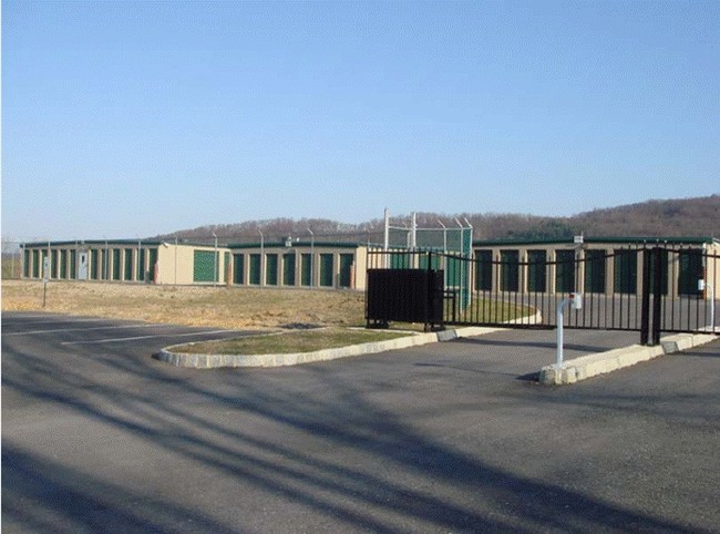
717 State Route 57
Allentown-Bethlehem-Easton, PA-NJ
Warren
07-00003-0000-00013
New Jersey
Sfr
9.76 AC
X
Warren County
34041C0303E
Northern New Jersey
1,740 SF
DEMOGRAPHICS near 717 State Route 57
1 Mile
3 Mile
5 Mile
2024 Total Population
1,435
18,740
60,217
2029 Population
1,466
19,252
61,513
Pop Growth 2024-2029
+ 2.16%
+ 2.73%
+ 2.15%
Average Age
43
43
41
2024 Total Households
521
7,327
23,100
HH Growth 2024-2029
+ 2.50%
+ 3.06%
+ 2.32%
Median Household Inc
$103,409
$88,174
$76,882
Avg Household Size
2.70
2.50
2.40
2024 Avg HH Vehicles
2.00
2.00
2.00
Median Home Value
$390,109
$313,998
$265,186
Median Year Built
1990
1981
1961
Nearby Places
Map Layers
Map Styles
 Street
 Aerial
- Restaurants
- Banks
- Shops
- Fitness
- Groceries
PUBLIC TRANSPORTATION
AIRPORT
Lehigh Valley International
DRIVE
WALK
Distance
Lehigh Valley International
32 min
19.3 mi
Freight Ports
New York Container Terminal
DRIVE
WALK
Distance
New York Container Terminal
81 min
60.5 mi
Nearby Properties
Address
Land Use
TOTAL SIZE
Lot Size
Zoning
Address
Land Use
TOTAL SIZE
Lot Size
Zoning
Address
Land Use
TOTAL SIZE
Lot Size
Zoning
511,200 SF
66.74 AC
HBRM
Address
Land Use
TOTAL SIZE
Lot Size
Zoning
54.61 AC
Address
Land Use
TOTAL SIZE
Lot Size
Zoning
48.27 AC
I2RA
Address
Land Use
TOTAL SIZE
Lot Size
Zoning
9.80 AC
B-1
Address
Land Use
TOTAL SIZE
Lot Size
Zoning
27.73 AC
RA-7
Address
Land Use
TOTAL SIZE
Lot Size
Zoning
20.65 AC
HBRM
Address
Land Use
TOTAL SIZE
Lot Size
Zoning
15,080 SF
34.28 AC
R120
Address
Land Use
TOTAL SIZE
Lot Size
Zoning
16.54 AC
Address
Land Use
TOTAL SIZE
Lot Size
Zoning
47.55 AC
B-3
Address
Land Use
TOTAL SIZE
Lot Size
Zoning
48.60 AC
B-3
Address
Land Use
TOTAL SIZE
Lot Size
Zoning
14.60 AC
RA-7
Address
Land Use
TOTAL SIZE
Lot Size
Zoning
28.79 AC
R-1
Address
Land Use
TOTAL SIZE
Lot Size
Zoning
43.49 AC
B-3
Address
Land Use
TOTAL SIZE
Lot Size
Zoning
15.02 AC
ROM
Address
Land Use
TOTAL SIZE
Lot Size
Zoning
5,600 SF
24.18 AC
B-I
Address
Land Use
TOTAL SIZE
Lot Size
Zoning
7.21 AC
B-3
Address
Land Use
TOTAL SIZE
Lot Size
Zoning
20.75 AC
B-1
Address
Land Use
TOTAL SIZE
Lot Size
Zoning
0.67 AC
B-I
Address
Land Use
TOTAL SIZE
Lot Size
Zoning
12.16 AC
Address
Land Use
TOTAL SIZE
Lot Size
Zoning
1,852 SF
10.43 AC
PO
Address
Land Use
TOTAL SIZE
Lot Size
Zoning
32.92 AC
HBRM
Address
Land Use
TOTAL SIZE
Lot Size
Zoning
10 AC
PO
Address
Land Use
TOTAL SIZE
Lot Size
Zoning
2.55 AC
R-50
Address
Land Use
TOTAL SIZE
Lot Size
Zoning
20.10 AC
R120
Address
Land Use
TOTAL SIZE
Lot Size
Zoning
94.49 AC
I2RA
Address
Land Use
TOTAL SIZE
Lot Size
Zoning
0.56 AC
B-1
Address
Land Use
TOTAL SIZE
Lot Size
Zoning
21.99 AC
ROM
Address
Land Use
TOTAL SIZE
Lot Size
Zoning
16.05 AC
HB
Address
Land Use
TOTAL SIZE
Lot Size
Zoning
0.89 AC
B-1
The World's #1 Commercial Real Estate Marketplace
Connect with us
© 2026 CoStar Group
The information above has been obtained from sources believed reliable. While we do not doubt its accuracy we have not verified it and make no guarantee, warranty or representation about it. It is your responsibility to independently confirm its accuracy and completeness. Any projections, opinions, assumptions, or estimates used are for example only and do not represent the current or future performance of the property. The value of this transaction to you depends on tax and other factors which should be evaluated by your tax, financial, and legal advisors. You and your advisors should conduct a careful, independent investigation of the property to determine to your satisfaction the suitability of the property for your needs.