Property Record
319 Merchant Dr, Knoxville, TN 37912
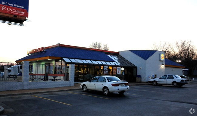

Property Detail
319 Merchant Dr
Knoxville, TN
SUBDIVISIONNAME REUBEN E DANIELS RESUB MAPPLATB 20 MAPP LATP 60 DIMENSIONS 152.82 X 330.7 X IRR
068KC-004
Knox
Restaurantdrivein
Tennessee
B and X Area of moderate flood hazard, usually the area between the limits of the 100-year and 500-year floods.
1r
2025
1.16 AC
2025
North/Broadway
004800
Knoxville
3,440 SF
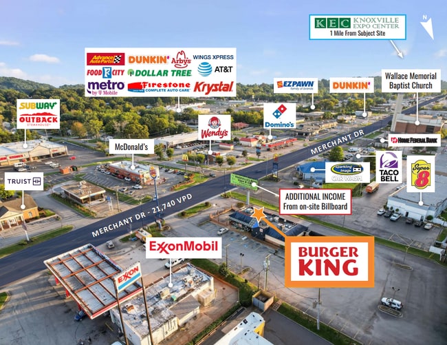
NEARBY LISTINGS FOR SALE OR LEASE
DEMOGRAPHICS near 319 Merchant Dr
1 mile
3 mile
5 mile
2024 Total Population
8,884
60,734
168,080
2029 Population
9,261
63,302
175,379
Pop Growth 2024-2029
+ 4.24%
+ 4.23%
+ 4.34%
Average Age
38
38
37
2024 Total Households
3,883
25,744
69,848
HH Growth 2024-2029
+ 4.17%
+ 4.18%
+ 4.55%
Median Household Inc
$44,756
$50,767
$52,992
Avg Household Size
2.20
2.30
2.20
2024 Avg HH Vehicles
2.00
2.00
2.00
Median Home Value
$217,257
$245,436
$277,981
Median Year Built
1976
1975
1977
Nearby Places
Map Layers
Map Styles
 Street
 Aerial
Transit
 Traffic
 Biking
Places
Listings with unknown addresses are not visible on the map
- Restaurants
- Banks
- Shops
- Fitness
- Groceries
PUBLIC TRANSPORTATION
AIRPORT
McGhee Tyson
Drive
Walk
Distance
McGhee Tyson
36 min
20.3 mi
SALE & LEASE HISTORY
LISTING DATE
SALE/LEASE

Oct 14, 2025
For Sale
Aug 21, 2024
For Sale
Aug 21, 2024
For Lease
Nearby Properties
Address
Land Use
TOTAL SIZE
Lot Size
Zoning
Address
Land Use
TOTAL SIZE
Lot Size
Zoning
52,072 SF
18.05 AC
Address
Land Use
TOTAL SIZE
Lot Size
Zoning
201,897 SF
2.07 AC
Address
Land Use
TOTAL SIZE
Lot Size
Zoning
4,922 SF
46.42 AC
Address
Land Use
TOTAL SIZE
Lot Size
Zoning
4,555 SF
23.09 AC
Address
Land Use
TOTAL SIZE
Lot Size
Zoning
8,050 SF
8 AC
Address
Land Use
TOTAL SIZE
Lot Size
Zoning
3,697 SF
16.71 AC
Address
Land Use
TOTAL SIZE
Lot Size
Zoning
77,112 SF
5.81 AC
Address
Land Use
TOTAL SIZE
Lot Size
Zoning
10,000 SF
4.85 AC
Address
Land Use
TOTAL SIZE
Lot Size
Zoning
347,788 SF
43.95 AC
Address
Land Use
TOTAL SIZE
Lot Size
Zoning
4,884 SF
22.38 AC
Address
Land Use
TOTAL SIZE
Lot Size
Zoning
35,784 SF
6.88 AC
Address
Land Use
TOTAL SIZE
Lot Size
Zoning
3,046 SF
13.43 AC
Address
Land Use
TOTAL SIZE
Lot Size
Zoning
1,218 SF
2.37 AC
Address
Land Use
TOTAL SIZE
Lot Size
Zoning
11,187 SF
9.85 AC
Address
Land Use
TOTAL SIZE
Lot Size
Zoning
122,198 SF
12.92 AC
Address
Land Use
TOTAL SIZE
Lot Size
Zoning
3,294 SF
10.07 AC
Address
Land Use
TOTAL SIZE
Lot Size
Zoning
35,520 SF
2.21 AC
Address
Land Use
TOTAL SIZE
Lot Size
Zoning
14,601 SF
15.03 AC
Address
Land Use
TOTAL SIZE
Lot Size
Zoning
9,924 SF
10.20 AC
Address
Land Use
TOTAL SIZE
Lot Size
Zoning
1,632 SF
18.91 AC
Address
Land Use
TOTAL SIZE
Lot Size
Zoning
50,857 SF
37.82 AC
Address
Land Use
TOTAL SIZE
Lot Size
Zoning
121,330 SF
5.50 AC
Address
Land Use
TOTAL SIZE
Lot Size
Zoning
14,270 SF
46.96 AC
Address
Land Use
TOTAL SIZE
Lot Size
Zoning
172,462 SF
22.86 AC
Address
Land Use
TOTAL SIZE
Lot Size
Zoning
211,808 SF
17.33 AC
Address
Land Use
TOTAL SIZE
Lot Size
Zoning
90,717 SF
31.69 AC
Address
Land Use
TOTAL SIZE
Lot Size
Zoning
96,514 SF
8.47 AC
Address
Land Use
TOTAL SIZE
Lot Size
Zoning
133,171 SF
11.96 AC
Address
Land Use
TOTAL SIZE
Lot Size
Zoning
25,302 SF
10.67 AC
Address
Land Use
TOTAL SIZE
Lot Size
Zoning
82,739 SF
7.95 AC
The World's #1 Commercial Real Estate Marketplace
Connect with us
© 2026 CoStar Group
The information above has been obtained from sources believed reliable. While we do not doubt its accuracy we have not verified it and make no guarantee, warranty or representation about it. It is your responsibility to independently confirm its accuracy and completeness. Any projections, opinions, assumptions, or estimates used are for example only and do not represent the current or future performance of the property. The value of this transaction to you depends on tax and other factors which should be evaluated by your tax, financial, and legal advisors. You and your advisors should conduct a careful, independent investigation of the property to determine to your satisfaction the suitability of the property for your needs.