Property Record
2 Chins Way, Nantucket, MA 02554
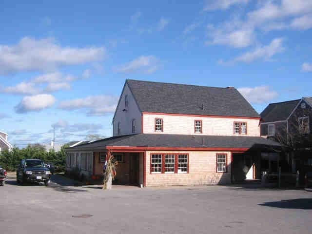

Property Detail
2 Chins Way
Commercialofficeresidentialmixeduse
Nantucket
CMI
Massachusetts
B and X Area of moderate flood hazard, usually the area between the limits of the 100-year and 500-year floods.
0.19 AC
0
Other Market Areas
2025
Nantucket, MA
950201
NANT-000-055-000-000-0001-62-000-000
NEARBY LISTINGS FOR SALE OR LEASE
DEMOGRAPHICS near 2 Chins Way
1 mile
3 mile
5 mile
2025 Total Population
4,745
11,338
12,641
2030 Population
4,658
11,233
12,646
Pop Growth 2025-2030
(1.83%)
(0.93%)
+ 0.04%
Average Age
40
40
41
2025 Total Households
1,790
4,221
4,761
HH Growth 2025-2030
(1.79%)
(1.04%)
(0.04%)
Median Household Inc
$123,126
$134,565
$135,012
Avg Household Size
2.40
2.50
2.50
2025 Avg HH Vehicles
2.00
2.00
2.00
Median Home Value
$1,116,450
$1,112,051
$1,113,576
Median Year Built
1984
1986
1986
Nearby Places
Map Layers
Map Styles
 Street
 Aerial
Transit
 Traffic
 Biking
Places
Listings with unknown addresses are not visible on the map
- Restaurants
- Banks
- Shops
- Fitness
- Groceries
PUBLIC TRANSPORTATION
AIRPORT
Nantucket Memorial
Drive
Walk
Distance
Nantucket Memorial
9 min
3.5 mi
Nearby Properties
Address
Land Use
TOTAL SIZE
Lot Size
Zoning
Address
Land Use
TOTAL SIZE
Lot Size
Zoning
8,971 SF
86.46 AC
CI
Address
Land Use
TOTAL SIZE
Lot Size
Zoning
864 SF
105.07 AC
CN
Address
Land Use
TOTAL SIZE
Lot Size
Zoning
8.10 AC
R10
Address
Land Use
TOTAL SIZE
Lot Size
Zoning
96.26 AC
CI
Address
Land Use
TOTAL SIZE
Lot Size
Zoning
14.79 AC
R10
Address
Land Use
TOTAL SIZE
Lot Size
Zoning
5.76 AC
CN
Address
Land Use
TOTAL SIZE
Lot Size
Zoning
15.30 AC
R40
Address
Land Use
TOTAL SIZE
Lot Size
Zoning
0.61 AC
CDT
Address
Land Use
TOTAL SIZE
Lot Size
Zoning
5,948 SF
2.21 AC
CDT
Address
Land Use
TOTAL SIZE
Lot Size
Zoning
11.96 AC
R40
Address
Land Use
TOTAL SIZE
Lot Size
Zoning
5.37 AC
R20
Address
Land Use
TOTAL SIZE
Lot Size
Zoning
13.91 AC
LUG3
Address
Land Use
TOTAL SIZE
Lot Size
Zoning
3.56 AC
LUG1
Address
Land Use
TOTAL SIZE
Lot Size
Zoning
24,975 SF
6.40 AC
CN
Address
Land Use
TOTAL SIZE
Lot Size
Zoning
3,032 SF
2.17 AC
R1
Address
Land Use
TOTAL SIZE
Lot Size
Zoning
6.65 AC
LUG2
Address
Land Use
TOTAL SIZE
Lot Size
Zoning
35.60 AC
LUG3
Address
Land Use
TOTAL SIZE
Lot Size
Zoning
6,226 SF
1.57 AC
R20
Address
Land Use
TOTAL SIZE
Lot Size
Zoning
2.07 AC
R20
Address
Land Use
TOTAL SIZE
Lot Size
Zoning
2,052 SF
3.30 AC
R40
Address
Land Use
TOTAL SIZE
Lot Size
Zoning
1.40 AC
R20
Address
Land Use
TOTAL SIZE
Lot Size
Zoning
4 AC
LUG1
Address
Land Use
TOTAL SIZE
Lot Size
Zoning
4.18 AC
LUG1
Address
Land Use
TOTAL SIZE
Lot Size
Zoning
9,016 SF
1.23 AC
R20
Address
Land Use
TOTAL SIZE
Lot Size
Zoning
1.37 AC
R20
Address
Land Use
TOTAL SIZE
Lot Size
Zoning
1.78 AC
LUG1
Address
Land Use
TOTAL SIZE
Lot Size
Zoning
18,458 SF
1.50 AC
CDT
Address
Land Use
TOTAL SIZE
Lot Size
Zoning
1.67 AC
R1
Address
Land Use
TOTAL SIZE
Lot Size
Zoning
1.50 AC
CN
Address
Land Use
TOTAL SIZE
Lot Size
Zoning
0.80 AC
R1
The World's #1 Commercial Real Estate Marketplace
Connect with us
© 2026 CoStar Group
The information above has been obtained from sources believed reliable. While we do not doubt its accuracy we have not verified it and make no guarantee, warranty or representation about it. It is your responsibility to independently confirm its accuracy and completeness. Any projections, opinions, assumptions, or estimates used are for example only and do not represent the current or future performance of the property. The value of this transaction to you depends on tax and other factors which should be evaluated by your tax, financial, and legal advisors. You and your advisors should conduct a careful, independent investigation of the property to determine to your satisfaction the suitability of the property for your needs.