Property Record
1892 Howell Mill Rd Nw, Atlanta, GA 30318


NEARBY LISTINGS FOR SALE OR LEASE
Property Detail
1892 Howell Mill Rd Nw
Atlanta-Sandy Springs-Roswell, GA
Alta/Acsm Land Title Surv
17-0153-0011-074-1
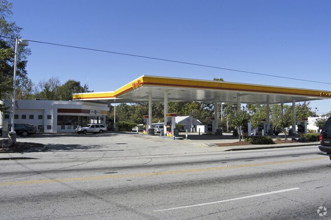
KA SHELL (BUILT 1996) AN OLD TEXACO DEMOED TO REBUILD VERIFIED DATA 1/5/17
Supermarket
Fulton
X
Georgia
13121C0241F
14
2024
0.63 AC
2025
Midtown/Brookwood
009001
Atlanta
2,964 SF
DEMOGRAPHICS near 1892 Howell Mill Rd Nw
1 Mile
3 Mile
5 Mile
2024 Total Population
14,471
142,531
364,976
2029 Population
14,715
148,032
378,037
Pop Growth 2024-2029
+ 1.69%
+ 3.86%
+ 3.58%
Average Age
34
36
37
2024 Total Households
7,718
72,089
178,137
HH Growth 2024-2029
+ 1.84%
+ 4.21%
+ 3.84%
Median Household Inc
$98,347
$95,836
$87,973
Avg Household Size
1.90
1.80
1.80
2024 Avg HH Vehicles
2.00
1.00
1.00
Median Home Value
$609,235
$563,379
$534,742
Median Year Built
1990
1999
1994
Nearby Places
Map Layers
Map Styles
 Street
 Aerial
- Restaurants
- Banks
- Shops
- Fitness
- Groceries
PUBLIC TRANSPORTATION
COMMUTER RAIL
DRIVE
WALK
Distance
4 min
1.9 mi
AIRPORT
Hartsfield - Jackson Atlanta International
DRIVE
WALK
Distance
Hartsfield - Jackson Atlanta International
22 min
14.2 mi
Nearby Properties
Address
Land Use
TOTAL SIZE
Lot Size
Zoning
Address
Land Use
TOTAL SIZE
Lot Size
Zoning
1,585,451 SF
1.97 AC
SPI2
Address
Land Use
TOTAL SIZE
Lot Size
Zoning
179.40 AC
R4
Address
Land Use
TOTAL SIZE
Lot Size
Zoning
1,039,831 SF
0.31 AC
C4
Address
Land Use
TOTAL SIZE
Lot Size
Zoning
1,227,912 SF
2.15 AC
SPI4
Address
Land Use
TOTAL SIZE
Lot Size
Zoning
1,736,017 SF
3.63 AC
SPI2
Address
Land Use
TOTAL SIZE
Lot Size
Zoning
2,044,200 SF
9.16 AC
C3
Address
Land Use
TOTAL SIZE
Lot Size
Zoning
1,116,157 SF
1.48 AC
SPI3
Address
Land Use
TOTAL SIZE
Lot Size
Zoning
1,467,469 SF
0.07 AC
C4
Address
Land Use
TOTAL SIZE
Lot Size
Zoning
903,671 SF
1 AC
C3
Address
Land Use
TOTAL SIZE
Lot Size
Zoning
10,954,869 SF
28.88 AC
C3
Address
Land Use
TOTAL SIZE
Lot Size
Zoning
1,646,011 SF
3.74 AC
SPI4
Address
Land Use
TOTAL SIZE
Lot Size
Zoning
342,275 SF
0.70 AC
SPI3
Address
Land Use
TOTAL SIZE
Lot Size
Zoning
654,394 SF
2.27 AC
C1C
Address
Land Use
TOTAL SIZE
Lot Size
Zoning
903,732 SF
0.34 AC
SPI1
Address
Land Use
TOTAL SIZE
Lot Size
Zoning
1,356,182 SF
2.52 AC
SPI4
Address
Land Use
TOTAL SIZE
Lot Size
Zoning
415,551 SF
1.13 AC
C4
Address
Land Use
TOTAL SIZE
Lot Size
Zoning
628,608 SF
0.39 AC
SPI4
Address
Land Use
TOTAL SIZE
Lot Size
Zoning
883,867 SF
2.71 AC
C1
Address
Land Use
TOTAL SIZE
Lot Size
Zoning
7,420 SF
0.13 AC
RG6
Address
Land Use
TOTAL SIZE
Lot Size
Zoning
899,982 SF
2.91 AC
C4
Address
Land Use
TOTAL SIZE
Lot Size
Zoning
687,016 SF
4.21 AC
R4
Address
Land Use
TOTAL SIZE
Lot Size
Zoning
787,339 SF
1.16 AC
SPI4
Address
Land Use
TOTAL SIZE
Lot Size
Zoning
519,160 SF
3.92 AC
I2
Address
Land Use
TOTAL SIZE
Lot Size
Zoning
935,056 SF
2.35 AC
SPI3
Address
Land Use
TOTAL SIZE
Lot Size
Zoning
658,880 SF
1.52 AC
C4
Address
Land Use
TOTAL SIZE
Lot Size
Zoning
1,142,168 SF
2.86 AC
C4
Address
Land Use
TOTAL SIZE
Lot Size
Zoning
32.79 AC
R3
Address
Land Use
TOTAL SIZE
Lot Size
Zoning
12.97 AC
C3
Address
Land Use
TOTAL SIZE
Lot Size
Zoning
2,971,832 SF
5.95 AC
SPI2
Address
Land Use
TOTAL SIZE
Lot Size
Zoning
742,537 SF
1.56 AC
C4
The World's #1 Commercial Real Estate Marketplace
Connect with us
© 2025 CoStar Group
The information above has been obtained from sources believed reliable. While we do not doubt its accuracy we have not verified it and make no guarantee, warranty or representation about it. It is your responsibility to independently confirm its accuracy and completeness. Any projections, opinions, assumptions, or estimates used are for example only and do not represent the current or future performance of the property. The value of this transaction to you depends on tax and other factors which should be evaluated by your tax, financial, and legal advisors. You and your advisors should conduct a careful, independent investigation of the property to determine to your satisfaction the suitability of the property for your needs.