Property Record
3400 N 85Th St, Lincoln, NE 68507
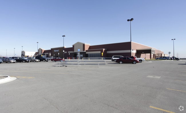

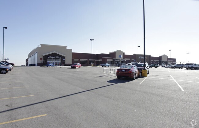
Property Detail
3400 N 85Th St
17-11-302-001-000
PRAIRIE VILLAGE NORTH ADDITION, BLOCK 2, LOT 1
Storebuilding
Lancaster
B2
Nebraska
B and X Area of moderate flood hazard, usually the area between the limits of the 100-year and 500-year floods.
1
2024
16.86 AC
2025
Northeast
003728
Lincoln
172,392 SF
Lincoln, NE
NEARBY LISTINGS FOR SALE OR LEASE
DEMOGRAPHICS near 3400 N 85Th St
1 mile
3 mile
5 mile
2025 Total Population
4,595
47,323
112,530
2030 Population
4,840
49,128
116,634
Pop Growth 2025-2030
+ 5.33%
+ 3.81%
+ 3.65%
Average Age
40
39
39
2025 Total Households
1,857
19,916
48,339
HH Growth 2025-2030
+ 5.76%
+ 4.07%
+ 3.96%
Median Household Inc
$100,694
$68,744
$64,873
Avg Household Size
2.40
2.30
2.20
2025 Avg HH Vehicles
2.00
2.00
2.00
Median Home Value
$301,835
$241,941
$243,771
Median Year Built
2010
1973
1975
Nearby Places
Map Layers
Map Styles
 Street
 Aerial
Layers
 Traffic
 Biking
Places
Listings with unknown addresses are not visible on the map
- Restaurants
- Banks
- Shops
- Fitness
- Groceries
PUBLIC TRANSPORTATION
COMMUTER RAIL
Drive
Walk
Distance
16 min
7.7 mi
AIRPORT
Lincoln
Drive
Walk
Distance
Lincoln
19 min
9.7 mi
Nearby Properties
Address
Land Use
TOTAL SIZE
Lot Size
Zoning
Address
Land Use
TOTAL SIZE
Lot Size
Zoning
382,244 SF
44.25 AC
R6
Address
Land Use
TOTAL SIZE
Lot Size
Zoning
531,687 SF
32.18 AC
B5
Address
Land Use
TOTAL SIZE
Lot Size
Zoning
47,866 SF
10.39 AC
R3
Address
Land Use
TOTAL SIZE
Lot Size
Zoning
32,110 SF
14.60 AC
R5
Address
Land Use
TOTAL SIZE
Lot Size
Zoning
430,949 SF
41.47 AC
P
Address
Land Use
TOTAL SIZE
Lot Size
Zoning
65,064 SF
1.39 AC
R6
Address
Land Use
TOTAL SIZE
Lot Size
Zoning
179,447 SF
7.85 AC
R6
Address
Land Use
TOTAL SIZE
Lot Size
Zoning
102,739 SF
4.24 AC
B2
Address
Land Use
TOTAL SIZE
Lot Size
Zoning
225,199 SF
31.18 AC
O3
Address
Land Use
TOTAL SIZE
Lot Size
Zoning
10,688 SF
237.77 AC
P
Address
Land Use
TOTAL SIZE
Lot Size
Zoning
46,906 SF
2.88 AC
Address
Land Use
TOTAL SIZE
Lot Size
Zoning
214,823 SF
19.37 AC
B5
Address
Land Use
TOTAL SIZE
Lot Size
Zoning
51,080 SF
12.42 AC
Address
Land Use
TOTAL SIZE
Lot Size
Zoning
73,737 SF
5.98 AC
B2
Address
Land Use
TOTAL SIZE
Lot Size
Zoning
92,054 SF
6.22 AC
R5
Address
Land Use
TOTAL SIZE
Lot Size
Zoning
69,760 SF
1.81 AC
Address
Land Use
TOTAL SIZE
Lot Size
Zoning
30,608 SF
25.92 AC
R4
Address
Land Use
TOTAL SIZE
Lot Size
Zoning
36,041 SF
5.43 AC
R5
Address
Land Use
TOTAL SIZE
Lot Size
Zoning
17,312 SF
177.49 AC
AG
Address
Land Use
TOTAL SIZE
Lot Size
Zoning
59,073 SF
18.66 AC
R4
Address
Land Use
TOTAL SIZE
Lot Size
Zoning
759,282 SF
40.67 AC
I1
Address
Land Use
TOTAL SIZE
Lot Size
Zoning
72,176 SF
8.65 AC
Address
Land Use
TOTAL SIZE
Lot Size
Zoning
129,485 SF
22.71 AC
O3
Address
Land Use
TOTAL SIZE
Lot Size
Zoning
37,044 SF
5.49 AC
R3
Address
Land Use
TOTAL SIZE
Lot Size
Zoning
80,763 SF
15.61 AC
R3
Address
Land Use
TOTAL SIZE
Lot Size
Zoning
60,298 SF
5.41 AC
NULL
Address
Land Use
TOTAL SIZE
Lot Size
Zoning
56,490 SF
17.25 AC
R2
Address
Land Use
TOTAL SIZE
Lot Size
Zoning
95,424 SF
6.50 AC
B5
Address
Land Use
TOTAL SIZE
Lot Size
Zoning
294,243 SF
93.02 AC
I1
Address
Land Use
TOTAL SIZE
Lot Size
Zoning
33,053 SF
12.84 AC
R4
The World's #1 Commercial Real Estate Marketplace
Connect with us
© 2026 CoStar Group
The information above has been obtained from sources believed reliable. While we do not doubt its accuracy we have not verified it and make no guarantee, warranty or representation about it. It is your responsibility to independently confirm its accuracy and completeness. Any projections, opinions, assumptions, or estimates used are for example only and do not represent the current or future performance of the property. The value of this transaction to you depends on tax and other factors which should be evaluated by your tax, financial, and legal advisors. You and your advisors should conduct a careful, independent investigation of the property to determine to your satisfaction the suitability of the property for your needs.