Property Record
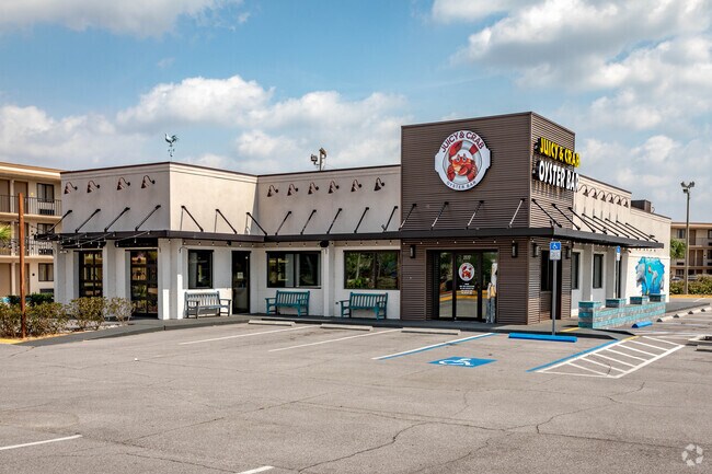
7777 W Irlo Bronson Memorial Hwy, Kissimmee, FL 34747


Property Detail
7777 W Irlo Bronson Memorial Hwy
03-25-27-0000-0012-0000
GC WEST PB 35 PG 82 LOT 1
Restaurantbuilding
Osceola
OTSC
Florida
A Areas with a 1% annual chance of flooding and a 26% chance of flooding over the life of a 30-year mortgage.
1
2024
1.64 AC
2025
Osceola Outlying
040806
Orlando
3,869 SF
Orlando-Kissimmee-Sanford, FL
NEARBY LISTINGS FOR SALE OR LEASE
DEMOGRAPHICS near 7777 W Irlo Bronson Memorial Hwy
1 mile
3 mile
5 mile
2025 Total Population
1,426
29,105
84,115
2030 Population
1,811
35,404
101,086
Pop Growth 2025-2030
+ 27.00%
+ 21.64%
+ 20.18%
Average Age
35
36
38
2025 Total Households
516
10,618
32,147
HH Growth 2025-2030
+ 27.52%
+ 22.24%
+ 20.59%
Median Household Inc
$72,828
$83,936
$87,236
Avg Household Size
2.70
2.70
2.60
2025 Avg HH Vehicles
2.00
2.00
2.00
Median Home Value
$428,333
$465,130
$446,841
Median Year Built
2005
2009
2007
Nearby Places
Map Layers
Map Styles
 Street
 Aerial
Layers
 Traffic
 Biking
Places
Listings with unknown addresses are not visible on the map
- Restaurants
- Banks
- Shops
- Fitness
- Groceries
PUBLIC TRANSPORTATION
AIRPORT
Orlando International
Drive
Walk
Distance
Orlando International
35 min
23.4 mi
Orlando Sanford International
Drive
Walk
Distance
Orlando Sanford International
65 min
49.3 mi
SALE & LEASE HISTORY
LISTING DATE
SALE/LEASE

Sep 23, 2016
For Sale
Oct 16, 2019
For Sale
Nov 14, 2018
For Sale
Nearby Properties
Address
Land Use
TOTAL SIZE
Lot Size
Zoning
Address
Land Use
TOTAL SIZE
Lot Size
Zoning
4,661,206 SF
277.42 AC
E
Address
Land Use
TOTAL SIZE
Lot Size
Zoning
386,104 SF
8.14 AC
Address
Land Use
TOTAL SIZE
Lot Size
Zoning
1,956,707 SF
209.24 AC
RCID
Address
Land Use
TOTAL SIZE
Lot Size
Zoning
1,314,060 SF
32.08 AC
P-D
Address
Land Use
TOTAL SIZE
Lot Size
Zoning
1,353,936 SF
523.88 AC
E
Address
Land Use
TOTAL SIZE
Lot Size
Zoning
1,432,727 SF
39.27 AC
H/R
Address
Land Use
TOTAL SIZE
Lot Size
Zoning
1,980,310 SF
140.63 AC
H/R
Address
Land Use
TOTAL SIZE
Lot Size
Zoning
883,200 SF
75.26 AC
P-D
Address
Land Use
TOTAL SIZE
Lot Size
Zoning
1,981,135 SF
2.60 AC
P-D
Address
Land Use
TOTAL SIZE
Lot Size
Zoning
1,906,663 SF
29.75 AC
P-D
Address
Land Use
TOTAL SIZE
Lot Size
Zoning
874,488 SF
159.54 AC
H/R
Address
Land Use
TOTAL SIZE
Lot Size
Zoning
571,384 SF
249.40 AC
RCID
Address
Land Use
TOTAL SIZE
Lot Size
Zoning
676,113 SF
24.67 AC
H/R
Address
Land Use
TOTAL SIZE
Lot Size
Zoning
283,974 SF
3.23 AC
P-D
Address
Land Use
TOTAL SIZE
Lot Size
Zoning
354,600 SF
12.03 AC
P-D
Address
Land Use
TOTAL SIZE
Lot Size
Zoning
331,691 SF
2.85 AC
H/R
Address
Land Use
TOTAL SIZE
Lot Size
Zoning
533,192 SF
70.52 AC
OPUD
Address
Land Use
TOTAL SIZE
Lot Size
Zoning
280,327 SF
16.27 AC
OCG
Address
Land Use
TOTAL SIZE
Lot Size
Zoning
457,911 SF
9.60 AC
P-D
Address
Land Use
TOTAL SIZE
Lot Size
Zoning
55,980 SF
57.91 AC
C
Address
Land Use
TOTAL SIZE
Lot Size
Zoning
480,142 SF
29.57 AC
OPD
Address
Land Use
TOTAL SIZE
Lot Size
Zoning
363,694 SF
17.65 AC
Address
Land Use
TOTAL SIZE
Lot Size
Zoning
418,368 SF
12.66 AC
Address
Land Use
TOTAL SIZE
Lot Size
Zoning
342,019 SF
23 AC
OCG
Address
Land Use
TOTAL SIZE
Lot Size
Zoning
305,617 SF
0.93 AC
P-D
Address
Land Use
TOTAL SIZE
Lot Size
Zoning
287,988 SF
P-D
Address
Land Use
TOTAL SIZE
Lot Size
Zoning
306,139 SF
19.77 AC
P-D
Address
Land Use
TOTAL SIZE
Lot Size
Zoning
348,661 SF
8.20 AC
Address
Land Use
TOTAL SIZE
Lot Size
Zoning
273,164 SF
P-D
Address
Land Use
TOTAL SIZE
Lot Size
Zoning
125,486 SF
30.26 AC
C
The World's #1 Commercial Real Estate Marketplace
Connect with us
© 2026 CoStar Group
The information above has been obtained from sources believed reliable. While we do not doubt its accuracy we have not verified it and make no guarantee, warranty or representation about it. It is your responsibility to independently confirm its accuracy and completeness. Any projections, opinions, assumptions, or estimates used are for example only and do not represent the current or future performance of the property. The value of this transaction to you depends on tax and other factors which should be evaluated by your tax, financial, and legal advisors. You and your advisors should conduct a careful, independent investigation of the property to determine to your satisfaction the suitability of the property for your needs.