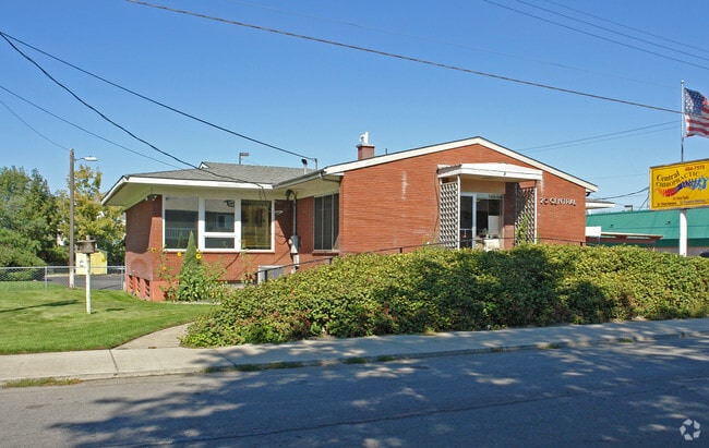
Property Record
22 W Central Ave, Spokane, WA 99205

Property Detail
22 W Central Ave
36311.1607
BYRNE ADD L21-22 B16
Commercialnec
Spokane
O
Washington
B and X Area of moderate flood hazard, usually the area between the limits of the 100-year and 500-year floods.
21-22
2025
0.18 AC
2025
SW North Metro
000500
Spokane
1,880 SF
Spokane-Spokane Valley, WA
NEARBY LISTINGS FOR SALE OR LEASE
DEMOGRAPHICS near 22 W Central Ave
1 mile
3 mile
5 mile
2025 Total Population
17,898
126,267
213,748
2030 Population
18,048
127,948
217,307
Pop Growth 2025-2030
+ 0.84%
+ 1.33%
+ 1.67%
Average Age
39
39
39
2025 Total Households
7,784
50,237
87,088
HH Growth 2025-2030
+ 0.82%
+ 1.35%
+ 1.82%
Median Household Inc
$57,559
$65,184
$64,918
Avg Household Size
2.20
2.40
2.30
2025 Avg HH Vehicles
2.00
2.00
2.00
Median Home Value
$298,228
$336,468
$364,236
Median Year Built
1960
1958
1966
Nearby Places
Map Layers
Map Styles
 Street
 Aerial
Transit
 Traffic
 Biking
Places
Listings with unknown addresses are not visible on the map
- Restaurants
- Banks
- Shops
- Fitness
- Groceries
PUBLIC TRANSPORTATION
COMMUTER RAIL
Drive
Walk
Distance
11 min
4.0 mi
AIRPORT
Spokane International
Drive
Walk
Distance
Spokane International
21 min
10.4 mi
SALE & LEASE HISTORY
LISTING DATE
SALE/LEASE

Mar 08, 2020
For Lease
Nearby Properties
Address
Land Use
TOTAL SIZE
Lot Size
Zoning
Address
Land Use
TOTAL SIZE
Lot Size
Zoning
531,295 SF
17.11 AC
CC2
Address
Land Use
TOTAL SIZE
Lot Size
Zoning
427,054 SF
16.60 AC
LI
Address
Land Use
TOTAL SIZE
Lot Size
Zoning
386,885 SF
22.81 AC
RSF
Address
Land Use
TOTAL SIZE
Lot Size
Zoning
310,606 SF
27.56 AC
RMF
Address
Land Use
TOTAL SIZE
Lot Size
Zoning
278,777 SF
5.47 AC
HDR
Address
Land Use
TOTAL SIZE
Lot Size
Zoning
180,822 SF
16.11 AC
CC1
Address
Land Use
TOTAL SIZE
Lot Size
Zoning
139,485 SF
16.74 AC
RSF
Address
Land Use
TOTAL SIZE
Lot Size
Zoning
456,984 SF
26.06 AC
O
Address
Land Use
TOTAL SIZE
Lot Size
Zoning
696,382 SF
37.43 AC
LI
Address
Land Use
TOTAL SIZE
Lot Size
Zoning
379,678 SF
20.64 AC
LI
Address
Land Use
TOTAL SIZE
Lot Size
Zoning
317,750 SF
31.10 AC
GC
Address
Land Use
TOTAL SIZE
Lot Size
Zoning
1,555,116 SF
23.12 AC
GC
Address
Land Use
TOTAL SIZE
Lot Size
Zoning
56,600 SF
4.98 AC
GC
Address
Land Use
TOTAL SIZE
Lot Size
Zoning
159,508 SF
18.52 AC
RSF
Address
Land Use
TOTAL SIZE
Lot Size
Zoning
124,249 SF
15.45 AC
RHD
Address
Land Use
TOTAL SIZE
Lot Size
Zoning
158,348 SF
6.60 AC
RMF
Address
Land Use
TOTAL SIZE
Lot Size
Zoning
117,687 SF
1.21 AC
GC
Address
Land Use
TOTAL SIZE
Lot Size
Zoning
134,806 SF
7.79 AC
RMF
Address
Land Use
TOTAL SIZE
Lot Size
Zoning
136,780 SF
8.75 AC
RMF
Address
Land Use
TOTAL SIZE
Lot Size
Zoning
101,372 SF
5.48 AC
RMF
Address
Land Use
TOTAL SIZE
Lot Size
Zoning
76,559 SF
7.11 AC
LDR
Address
Land Use
TOTAL SIZE
Lot Size
Zoning
102,142 SF
1.03 AC
GC
Address
Land Use
TOTAL SIZE
Lot Size
Zoning
131,469 SF
7.24 AC
RMF
Address
Land Use
TOTAL SIZE
Lot Size
Zoning
150,061 SF
5.01 AC
GC
Address
Land Use
TOTAL SIZE
Lot Size
Zoning
153,780 SF
10.31 AC
RMF
Address
Land Use
TOTAL SIZE
Lot Size
Zoning
95,030 SF
3.51 AC
CC1
Address
Land Use
TOTAL SIZE
Lot Size
Zoning
67,094 SF
9.33 AC
RSF
Address
Land Use
TOTAL SIZE
Lot Size
Zoning
209,047 SF
41.68 AC
HI
Address
Land Use
TOTAL SIZE
Lot Size
Zoning
160,810 SF
25.18 AC
RMF
Address
Land Use
TOTAL SIZE
Lot Size
Zoning
113,638 SF
34.05 AC
RSF
The World's #1 Commercial Real Estate Marketplace
Connect with us
© 2026 CoStar Group
The information above has been obtained from sources believed reliable. While we do not doubt its accuracy we have not verified it and make no guarantee, warranty or representation about it. It is your responsibility to independently confirm its accuracy and completeness. Any projections, opinions, assumptions, or estimates used are for example only and do not represent the current or future performance of the property. The value of this transaction to you depends on tax and other factors which should be evaluated by your tax, financial, and legal advisors. You and your advisors should conduct a careful, independent investigation of the property to determine to your satisfaction the suitability of the property for your needs.