Property Record
855 N 3Rd St, Tipp City, OH 45371
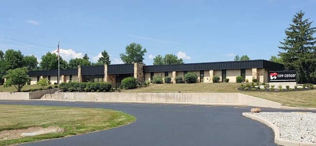

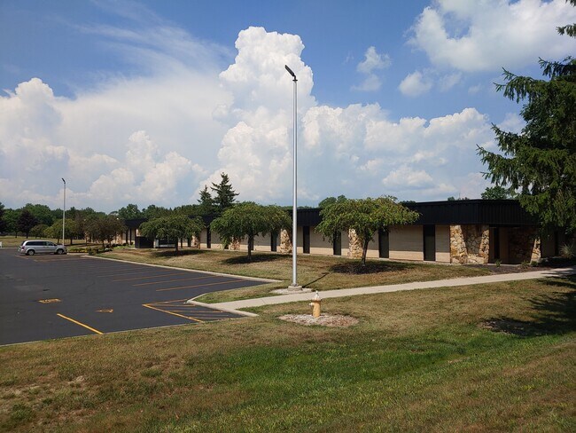
Property Detail
855 N 3Rd St
Dayton, OH
PT IL 1775
G15019185
MIAMI
Officebuilding
Ohio
B and X Area of moderate flood hazard, usually the area between the limits of the 100-year and 500-year floods.
1775
2025
10.71 AC
2025
North Dayton
355002
Cincinnati/Dayton
32,166 SF
NEARBY LISTINGS FOR SALE OR LEASE
DEMOGRAPHICS near 855 N 3Rd St
1 mile
3 mile
5 mile
2025 Total Population
2,911
16,061
33,904
2030 Population
2,982
16,533
34,800
Pop Growth 2025-2030
+ 2.44%
+ 2.94%
+ 2.64%
Average Age
40
43
42
2025 Total Households
1,322
6,505
13,772
HH Growth 2025-2030
+ 2.50%
+ 2.89%
+ 2.64%
Median Household Inc
$77,491
$87,900
$82,512
Avg Household Size
2.20
2.40
2.40
2025 Avg HH Vehicles
2.00
2.00
2.00
Median Home Value
$182,603
$296,899
$285,442
Median Year Built
1968
1977
1972
Nearby Places
Map Layers
Map Styles
 Street
 Aerial
Transit
 Traffic
 Biking
Places
Listings with unknown addresses are not visible on the map
- Restaurants
- Banks
- Shops
- Fitness
- Groceries
PUBLIC TRANSPORTATION
AIRPORT
James M Cox Dayton International
Drive
Walk
Distance
James M Cox Dayton International
20 min
10.6 mi
Freight Ports
Port of Toledo
Drive
Walk
Distance
Port of Toledo
166 min
140.8 mi
SALE & LEASE HISTORY
LISTING DATE
SALE/LEASE

Sep 25, 2016
For Lease
Sep 24, 2016
For Sale
Oct 10, 2016
For Sale
Mar 07, 2019
For Lease
Apr 04, 2017
For Sale
Nearby Properties
Address
Land Use
TOTAL SIZE
Lot Size
Zoning
Address
Land Use
TOTAL SIZE
Lot Size
Zoning
209,484 SF
45.46 AC
Address
Land Use
TOTAL SIZE
Lot Size
Zoning
Address
Land Use
TOTAL SIZE
Lot Size
Zoning
Address
Land Use
TOTAL SIZE
Lot Size
Zoning
Address
Land Use
TOTAL SIZE
Lot Size
Zoning
38,738 SF
11.39 AC
Address
Land Use
TOTAL SIZE
Lot Size
Zoning
178.04 AC
Address
Land Use
TOTAL SIZE
Lot Size
Zoning
Address
Land Use
TOTAL SIZE
Lot Size
Zoning
27,623 SF
6.54 AC
Address
Land Use
TOTAL SIZE
Lot Size
Zoning
54,635 SF
17.25 AC
Address
Land Use
TOTAL SIZE
Lot Size
Zoning
49,496 SF
10.15 AC
Address
Land Use
TOTAL SIZE
Lot Size
Zoning
Address
Land Use
TOTAL SIZE
Lot Size
Zoning
371,869 SF
160.30 AC
Address
Land Use
TOTAL SIZE
Lot Size
Zoning
Address
Land Use
TOTAL SIZE
Lot Size
Zoning
87,635 SF
6.02 AC
Address
Land Use
TOTAL SIZE
Lot Size
Zoning
198,355 SF
19.64 AC
Address
Land Use
TOTAL SIZE
Lot Size
Zoning
6,263 SF
26.04 AC
Address
Land Use
TOTAL SIZE
Lot Size
Zoning
28,208 SF
10.32 AC
Address
Land Use
TOTAL SIZE
Lot Size
Zoning
21,473 SF
8.37 AC
Address
Land Use
TOTAL SIZE
Lot Size
Zoning
9,900 SF
4.24 AC
Address
Land Use
TOTAL SIZE
Lot Size
Zoning
9,832 SF
0.83 AC
Address
Land Use
TOTAL SIZE
Lot Size
Zoning
4,579 SF
0.54 AC
Address
Land Use
TOTAL SIZE
Lot Size
Zoning
96,200 SF
14.09 AC
Address
Land Use
TOTAL SIZE
Lot Size
Zoning
14,850 SF
1.78 AC
Address
Land Use
TOTAL SIZE
Lot Size
Zoning
8,576 SF
6.19 AC
Address
Land Use
TOTAL SIZE
Lot Size
Zoning
26,250 SF
3.90 AC
Address
Land Use
TOTAL SIZE
Lot Size
Zoning
12,948 SF
2.88 AC
Address
Land Use
TOTAL SIZE
Lot Size
Zoning
13,944 SF
7.39 AC
Address
Land Use
TOTAL SIZE
Lot Size
Zoning
122,400 SF
20.34 AC
Address
Land Use
TOTAL SIZE
Lot Size
Zoning
16,256 SF
10.42 AC
Address
Land Use
TOTAL SIZE
Lot Size
Zoning
41,084 SF
13.28 AC
The World's #1 Commercial Real Estate Marketplace
Connect with us
© 2026 CoStar Group
The information above has been obtained from sources believed reliable. While we do not doubt its accuracy we have not verified it and make no guarantee, warranty or representation about it. It is your responsibility to independently confirm its accuracy and completeness. Any projections, opinions, assumptions, or estimates used are for example only and do not represent the current or future performance of the property. The value of this transaction to you depends on tax and other factors which should be evaluated by your tax, financial, and legal advisors. You and your advisors should conduct a careful, independent investigation of the property to determine to your satisfaction the suitability of the property for your needs.