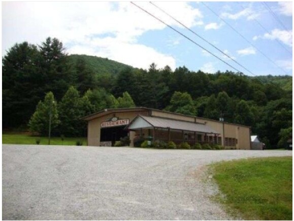
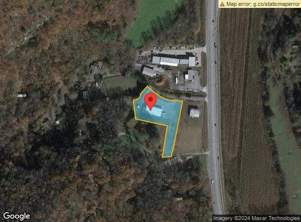
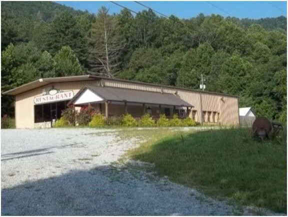
Property Record
33 Sherin Dr, Rabun Gap, GA 30568
Property Detail
33 Sherin Dr
040-047
Acres Ll
Commercialnec
2.18 ACRES LL 106 LD 2 06TY AC COR
A
Rabun
13241C0117D
Georgia
2025
2.18 AC
2025
Georgia Northeast
970101
Other Market Areas
5,000 SF
NEARBY LISTINGS FOR SALE OR LEASE
-
-
View all Rabun Gap listings for sale on LoopNet.com
DEMOGRAPHICS near 33 Sherin Dr
1 mile
3 mile
5 mile
2024 Total Population
391
2,737
7,448
2029 Population
400
2,794
7,612
Pop Growth 2024-2029
+ 2.30%
+ 2.08%
+ 2.20%
Average Age
46
46
45
2024 Total Households
167
1,173
3,208
HH Growth 2024-2029
+ 2.40%
+ 1.79%
+ 1.96%
Median Household Inc
$44,999
$48,201
$49,815
Avg Household Size
2.30
2.30
2.30
2024 Avg HH Vehicles
2.00
2.00
2.00
Median Home Value
$212,500
$213,043
$226,562
Median Year Built
1980
1980
1982
Nearby Places
Map Layers
Map Styles
 Street
 Aerial
Transit
 Traffic
 Biking
Places
Listings with unknown addresses are not visible on the map
- Restaurants
- Banks
- Shops
- Fitness
- Groceries
Nearby Properties
Address
Land Use
TOTAL SIZE
Lot Size
Zoning
Address
Land Use
TOTAL SIZE
Lot Size
Zoning
47,207 SF
9.84 AC
HB
Address
Land Use
TOTAL SIZE
Lot Size
Zoning
1,520 SF
1,083.77 AC
A
Address
Land Use
TOTAL SIZE
Lot Size
Zoning
977,485 SF
85.55 AC
M1
Address
Land Use
TOTAL SIZE
Lot Size
Zoning
769,487 SF
170.62 AC
M2
Address
Land Use
TOTAL SIZE
Lot Size
Zoning
8,820 SF
60.34 AC
CB
Address
Land Use
TOTAL SIZE
Lot Size
Zoning
314.37 AC
A
Address
Land Use
TOTAL SIZE
Lot Size
Zoning
7,854 SF
12.92 AC
HB
Address
Land Use
TOTAL SIZE
Lot Size
Zoning
47,704 SF
3.38 AC
CB
Address
Land Use
TOTAL SIZE
Lot Size
Zoning
71,838 SF
11.98 AC
M1
Address
Land Use
TOTAL SIZE
Lot Size
Zoning
18,800 SF
1.07 AC
CB
Address
Land Use
TOTAL SIZE
Lot Size
Zoning
12,300 SF
2.42 AC
CB
Address
Land Use
TOTAL SIZE
Lot Size
Zoning
4,623 SF
1.65 AC
HB
Address
Land Use
TOTAL SIZE
Lot Size
Zoning
4,304 SF
1.66 AC
HB
Address
Land Use
TOTAL SIZE
Lot Size
Zoning
4,908 SF
6.30 AC
HB
Address
Land Use
TOTAL SIZE
Lot Size
Zoning
30,631 SF
4.11 AC
Address
Land Use
TOTAL SIZE
Lot Size
Zoning
8,289 SF
0.74 AC
CB
Address
Land Use
TOTAL SIZE
Lot Size
Zoning
28,000 SF
6.71 AC
M2
Address
Land Use
TOTAL SIZE
Lot Size
Zoning
69.11 AC
M1
Address
Land Use
TOTAL SIZE
Lot Size
Zoning
977,485 SF
4.64 AC
M1
Address
Land Use
TOTAL SIZE
Lot Size
Zoning
20,605 SF
3.52 AC
CB
Address
Land Use
TOTAL SIZE
Lot Size
Zoning
3,600 SF
0.65 AC
CB
Address
Land Use
TOTAL SIZE
Lot Size
Zoning
45.64 AC
A
Address
Land Use
TOTAL SIZE
Lot Size
Zoning
27,848 SF
7.25 AC
R1
Address
Land Use
TOTAL SIZE
Lot Size
Zoning
4,318 SF
0.47 AC
CB
Address
Land Use
TOTAL SIZE
Lot Size
Zoning
3,500 SF
6.32 AC
CB
Address
Land Use
TOTAL SIZE
Lot Size
Zoning
10,302 SF
4.94 AC
Address
Land Use
TOTAL SIZE
Lot Size
Zoning
63.32 AC
A
Address
Land Use
TOTAL SIZE
Lot Size
Zoning
3,988 SF
8.38 AC
M1
Address
Land Use
TOTAL SIZE
Lot Size
Zoning
8,420 SF
0.78 AC
The World's #1 Commercial Real Estate Marketplace
Connect with us
© 2026 CoStar Group
The information above has been obtained from sources believed reliable. While we do not doubt its accuracy we have not verified it and make no guarantee, warranty or representation about it. It is your responsibility to independently confirm its accuracy and completeness. Any projections, opinions, assumptions, or estimates used are for example only and do not represent the current or future performance of the property. The value of this transaction to you depends on tax and other factors which should be evaluated by your tax, financial, and legal advisors. You and your advisors should conduct a careful, independent investigation of the property to determine to your satisfaction the suitability of the property for your needs.