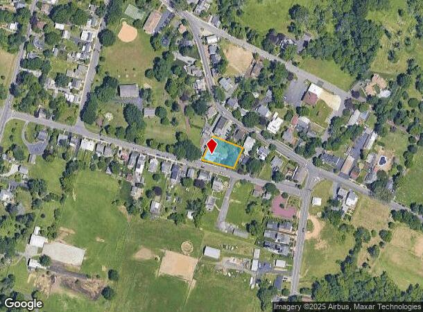
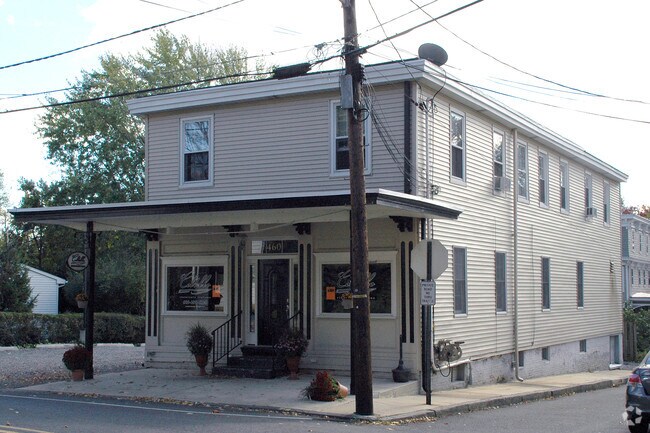
Property Record
460 Main St, Chesterfield, NJ 08515

Property Detail
460 Main St
07-00201-0000-00006-02
Burlington
Restaurantbuilding
New Jersey
X
6.2
34005C0044F
0.14 AC
2024
South Burlington County
2025
Philadelphia
704302
Philadelphia-Camden-Wilmington, PA-NJ-DE-MD
3,426 SF
NEARBY LISTINGS FOR SALE OR LEASE
DEMOGRAPHICS near 460 Main St
1 mile
3 mile
5 mile
2024 Total Population
1,872
25,420
72,512
2029 Population
1,875
25,511
72,399
Pop Growth 2024-2029
+ 0.16%
+ 0.36%
(0.16%)
Average Age
37
40
42
2024 Total Households
585
8,269
27,291
HH Growth 2024-2029
0.00%
+ 0.28%
(0.31%)
Median Household Inc
$178,684
$113,506
$102,822
Avg Household Size
3.20
2.70
2.50
2024 Avg HH Vehicles
2.00
2.00
2.00
Median Home Value
$466,666
$355,748
$320,002
Median Year Built
2003
1979
1973
Nearby Places
Map Layers
Map Styles
 Street
 Aerial
Transit
 Traffic
 Biking
Places
Listings with unknown addresses are not visible on the map
- Restaurants
- Banks
- Shops
- Fitness
- Groceries
PUBLIC TRANSPORTATION
COMMUTER RAIL
Trenton Transit Center (NJT) (Northeast Corridor Line - NJ Transit Commuter Rail (NJ Transit), River LINE - River LINE (River LINE))
Drive
Walk
Distance
Trenton Transit Center (NJT) (Northeast Corridor Line - NJ Transit Commuter Rail (NJ Transit), River LINE - River LINE (River LINE))
18 min
8.5 mi
Drive
Walk
Distance
15 min
9.1 mi
AIRPORT
Trenton Mercer
Drive
Walk
Distance
Trenton Mercer
27 min
15.1 mi
Philadelphia International
Drive
Walk
Distance
Philadelphia International
64 min
43.5 mi
Freight Ports
South Jersey Port
Drive
Walk
Distance
South Jersey Port
47 min
33.3 mi
Nearby Properties
Address
Land Use
TOTAL SIZE
Lot Size
Zoning
Address
Land Use
TOTAL SIZE
Lot Size
Zoning
561.91 AC
AG
Address
Land Use
TOTAL SIZE
Lot Size
Zoning
31.05 AC
Address
Land Use
TOTAL SIZE
Lot Size
Zoning
30.94 AC
Address
Land Use
TOTAL SIZE
Lot Size
Zoning
51.10 AC
Address
Land Use
TOTAL SIZE
Lot Size
Zoning
2,030 SF
45.57 AC
Address
Land Use
TOTAL SIZE
Lot Size
Zoning
Address
Land Use
TOTAL SIZE
Lot Size
Zoning
134,000 SF
117.90 AC
AR
Address
Land Use
TOTAL SIZE
Lot Size
Zoning
2,350 SF
8.80 AC
PVD2
Address
Land Use
TOTAL SIZE
Lot Size
Zoning
Address
Land Use
TOTAL SIZE
Lot Size
Zoning
Address
Land Use
TOTAL SIZE
Lot Size
Zoning
55.49 AC
RD
Address
Land Use
TOTAL SIZE
Lot Size
Zoning
15,096 SF
21.76 AC
AT
Address
Land Use
TOTAL SIZE
Lot Size
Zoning
Address
Land Use
TOTAL SIZE
Lot Size
Zoning
50,438 SF
9.32 AC
HC
Address
Land Use
TOTAL SIZE
Lot Size
Zoning
Address
Land Use
TOTAL SIZE
Lot Size
Zoning
51,000 SF
6.78 AC
Address
Land Use
TOTAL SIZE
Lot Size
Zoning
4.12 AC
Address
Land Use
TOTAL SIZE
Lot Size
Zoning
Address
Land Use
TOTAL SIZE
Lot Size
Zoning
6.93 AC
HC
Address
Land Use
TOTAL SIZE
Lot Size
Zoning
63.51 AC
RRC
Address
Land Use
TOTAL SIZE
Lot Size
Zoning
11.43 AC
Address
Land Use
TOTAL SIZE
Lot Size
Zoning
16.38 AC
RD
Address
Land Use
TOTAL SIZE
Lot Size
Zoning
459 SF
38.99 AC
R15
Address
Land Use
TOTAL SIZE
Lot Size
Zoning
5.93 AC
CC
Address
Land Use
TOTAL SIZE
Lot Size
Zoning
22,542 SF
4.18 AC
HC
Address
Land Use
TOTAL SIZE
Lot Size
Zoning
13.46 AC
RD
Address
Land Use
TOTAL SIZE
Lot Size
Zoning
1,768 SF
14.09 AC
Address
Land Use
TOTAL SIZE
Lot Size
Zoning
6.76 AC
R7
Address
Land Use
TOTAL SIZE
Lot Size
Zoning
14,860 SF
19.80 AC
RRC
Address
Land Use
TOTAL SIZE
Lot Size
Zoning
1,590 SF
26.43 AC
AG
The World's #1 Commercial Real Estate Marketplace
Connect with us
© 2026 CoStar Group
The information above has been obtained from sources believed reliable. While we do not doubt its accuracy we have not verified it and make no guarantee, warranty or representation about it. It is your responsibility to independently confirm its accuracy and completeness. Any projections, opinions, assumptions, or estimates used are for example only and do not represent the current or future performance of the property. The value of this transaction to you depends on tax and other factors which should be evaluated by your tax, financial, and legal advisors. You and your advisors should conduct a careful, independent investigation of the property to determine to your satisfaction the suitability of the property for your needs.