Property Record
2315 N Main St, Mansfield, TX 76063
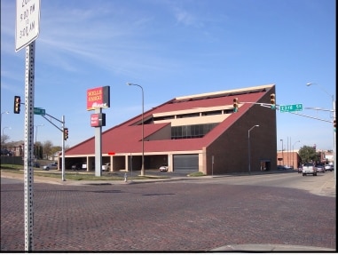

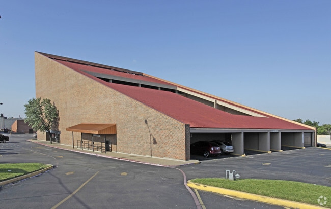
Property Detail
2315 N Main St
Dallas-Fort Worth-Arlington, TX
ELLIS, M G ADDITION BLOCK 1 LOT R2
00825433
TARRANT
Commercialnec
Texas
B and X Area of moderate flood hazard, usually the area between the limits of the 100-year and 500-year floods.
r2
2024
3.27 AC
2025
Northwest Ft Worth
111406
Dallas/Ft Worth
127,761 SF
NEARBY LISTINGS FOR SALE OR LEASE
DEMOGRAPHICS near 2315 N Main St
1 mile
3 mile
5 mile
2024 Total Population
12,220
100,621
240,932
2029 Population
12,858
106,706
256,176
Pop Growth 2024-2029
+ 5.22%
+ 6.05%
+ 6.33%
Average Age
36
36
37
2024 Total Households
3,595
35,798
86,057
HH Growth 2024-2029
+ 5.40%
+ 6.72%
+ 6.63%
Median Household Inc
$51,964
$61,216
$65,997
Avg Household Size
3.30
2.60
2.60
2024 Avg HH Vehicles
2.00
2.00
2.00
Median Home Value
$169,372
$220,345
$266,742
Median Year Built
1948
1972
1975
Nearby Places
Map Layers
Map Styles
 Street
 Aerial
Transit
 Traffic
 Biking
Places
Listings with unknown addresses are not visible on the map
- Restaurants
- Banks
- Shops
- Fitness
- Groceries
PUBLIC TRANSPORTATION
COMMUTER RAIL
Drive
Walk
Distance
7 min
3.3 mi
Drive
Walk
Distance
7 min
3.3 mi
AIRPORT
Dallas-Fort Worth International
Drive
Walk
Distance
Dallas-Fort Worth International
37 min
26.6 mi
Dallas Love Field
Drive
Walk
Distance
Dallas Love Field
48 min
35.2 mi
Nearby Properties
Address
Land Use
TOTAL SIZE
Lot Size
Zoning
Address
Land Use
TOTAL SIZE
Lot Size
Zoning
133,700 SF
6.29 AC
Address
Land Use
TOTAL SIZE
Lot Size
Zoning
738,487 SF
2.11 AC
Address
Land Use
TOTAL SIZE
Lot Size
Zoning
1,009,233 SF
0.92 AC
Address
Land Use
TOTAL SIZE
Lot Size
Zoning
616,686 SF
2.82 AC
Address
Land Use
TOTAL SIZE
Lot Size
Zoning
773,033 SF
2.11 AC
Address
Land Use
TOTAL SIZE
Lot Size
Zoning
1,281,000 SF
1.15 AC
Address
Land Use
TOTAL SIZE
Lot Size
Zoning
551,198 SF
3.12 AC
Address
Land Use
TOTAL SIZE
Lot Size
Zoning
508,378 SF
6.02 AC
Address
Land Use
TOTAL SIZE
Lot Size
Zoning
650,744 SF
15.68 AC
Address
Land Use
TOTAL SIZE
Lot Size
Zoning
884,928 SF
1.01 AC
Address
Land Use
TOTAL SIZE
Lot Size
Zoning
205,807 SF
3.19 AC
Address
Land Use
TOTAL SIZE
Lot Size
Zoning
1,024,627 SF
0.83 AC
Address
Land Use
TOTAL SIZE
Lot Size
Zoning
764,691 SF
0.92 AC
Address
Land Use
TOTAL SIZE
Lot Size
Zoning
914,300 SF
3.46 AC
Address
Land Use
TOTAL SIZE
Lot Size
Zoning
774,327 SF
11.86 AC
Address
Land Use
TOTAL SIZE
Lot Size
Zoning
1,719,136 SF
18.18 AC
Address
Land Use
TOTAL SIZE
Lot Size
Zoning
586,500 SF
159.54 AC
Address
Land Use
TOTAL SIZE
Lot Size
Zoning
537,395 SF
2.82 AC
Address
Land Use
TOTAL SIZE
Lot Size
Zoning
788,621 SF
6.39 AC
Address
Land Use
TOTAL SIZE
Lot Size
Zoning
498,381 SF
5.26 AC
Address
Land Use
TOTAL SIZE
Lot Size
Zoning
750,215 SF
0.69 AC
Address
Land Use
TOTAL SIZE
Lot Size
Zoning
765,141 SF
56.28 AC
Address
Land Use
TOTAL SIZE
Lot Size
Zoning
336,310 SF
2.85 AC
Address
Land Use
TOTAL SIZE
Lot Size
Zoning
487,426 SF
4.18 AC
Address
Land Use
TOTAL SIZE
Lot Size
Zoning
419,815 SF
10.26 AC
Address
Land Use
TOTAL SIZE
Lot Size
Zoning
581,601 SF
3.77 AC
Address
Land Use
TOTAL SIZE
Lot Size
Zoning
423,917 SF
4.20 AC
Address
Land Use
TOTAL SIZE
Lot Size
Zoning
1,009,800 SF
49.98 AC
Address
Land Use
TOTAL SIZE
Lot Size
Zoning
462,036 SF
5.40 AC
Address
Land Use
TOTAL SIZE
Lot Size
Zoning
363,192 SF
2.62 AC
The World's #1 Commercial Real Estate Marketplace
Connect with us
© 2026 CoStar Group
The information above has been obtained from sources believed reliable. While we do not doubt its accuracy we have not verified it and make no guarantee, warranty or representation about it. It is your responsibility to independently confirm its accuracy and completeness. Any projections, opinions, assumptions, or estimates used are for example only and do not represent the current or future performance of the property. The value of this transaction to you depends on tax and other factors which should be evaluated by your tax, financial, and legal advisors. You and your advisors should conduct a careful, independent investigation of the property to determine to your satisfaction the suitability of the property for your needs.