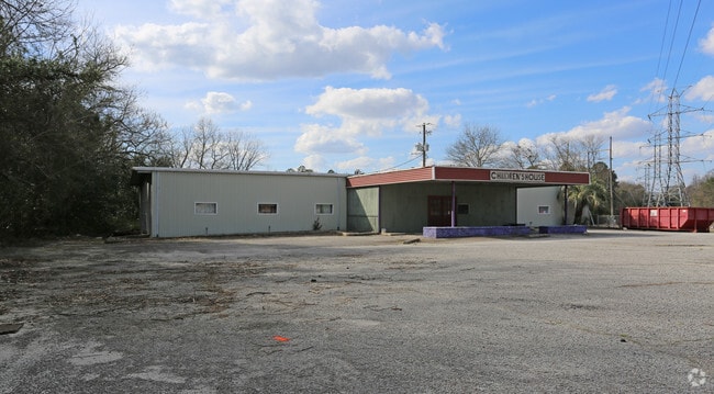
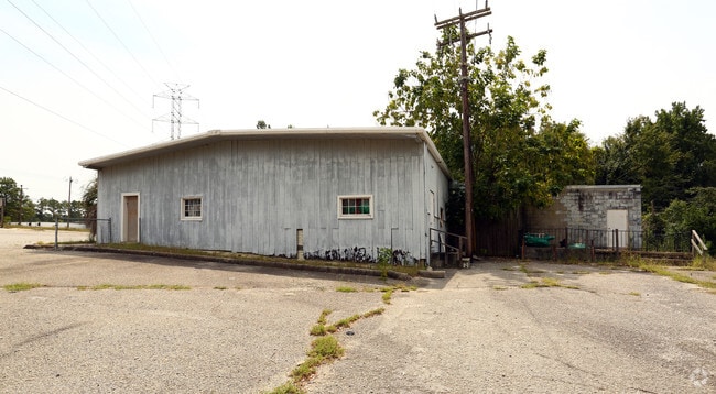
Property Record
2030 Charleston Hwy, Cayce, SC 29033

Property Detail
2030 Charleston Hwy
Daycare
Lexington
M1
South Carolina
B and X Area of moderate flood hazard, usually the area between the limits of the 100-year and 500-year floods.
2.38 AC
2025
Cayce/West Columbia
2024
Columbia
020202
Columbia, SC
7,517 SF
005744-01-011
NEARBY LISTINGS FOR SALE OR LEASE
DEMOGRAPHICS near 2030 Charleston Hwy
1 mile
3 mile
5 mile
2024 Total Population
5,189
33,046
104,147
2029 Population
5,405
34,744
108,911
Pop Growth 2024-2029
+ 4.16%
+ 5.14%
+ 4.57%
Average Age
42
40
37
2024 Total Households
2,248
14,888
45,532
HH Growth 2024-2029
+ 4.36%
+ 5.39%
+ 4.89%
Median Household Inc
$53,464
$54,493
$55,521
Avg Household Size
2.20
2.10
2.10
2024 Avg HH Vehicles
2.00
2.00
2.00
Median Home Value
$160,621
$184,117
$214,549
Median Year Built
1969
1972
1978
Nearby Places
Map Layers
Map Styles
 Street
 Aerial
Transit
 Traffic
 Biking
Places
Listings with unknown addresses are not visible on the map
- Restaurants
- Banks
- Shops
- Fitness
- Groceries
PUBLIC TRANSPORTATION
COMMUTER RAIL
Drive
Walk
Distance
10 min
4.8 mi
AIRPORT
Columbia Metro
Drive
Walk
Distance
Columbia Metro
16 min
6.0 mi
Nearby Properties
Address
Land Use
TOTAL SIZE
Lot Size
Zoning
Address
Land Use
TOTAL SIZE
Lot Size
Zoning
121,560 SF
8.46 AC
RM-2
Address
Land Use
TOTAL SIZE
Lot Size
Zoning
152,064 SF
9.58 AC
RM-2
Address
Land Use
TOTAL SIZE
Lot Size
Zoning
158,976 SF
11.28 AC
RM-2
Address
Land Use
TOTAL SIZE
Lot Size
Zoning
3,614 SF
1,444.32 AC
ID
Address
Land Use
TOTAL SIZE
Lot Size
Zoning
62,886 SF
10.15 AC
C3
Address
Land Use
TOTAL SIZE
Lot Size
Zoning
20.65 AC
T/C
Address
Land Use
TOTAL SIZE
Lot Size
Zoning
4,586 SF
19.15 AC
Address
Land Use
TOTAL SIZE
Lot Size
Zoning
21,018 SF
7.25 AC
R
Address
Land Use
TOTAL SIZE
Lot Size
Zoning
25,240 SF
9 AC
RG
Address
Land Use
TOTAL SIZE
Lot Size
Zoning
87,936 SF
4.40 AC
HI
Address
Land Use
TOTAL SIZE
Lot Size
Zoning
1,218 SF
8.99 AC
RG
Address
Land Use
TOTAL SIZE
Lot Size
Zoning
3,702 SF
19 AC
C3
Address
Land Use
TOTAL SIZE
Lot Size
Zoning
1,924 SF
12.27 AC
R4
Address
Land Use
TOTAL SIZE
Lot Size
Zoning
30,052 SF
3.84 AC
Address
Land Use
TOTAL SIZE
Lot Size
Zoning
297,500 SF
20.26 AC
ID
Address
Land Use
TOTAL SIZE
Lot Size
Zoning
8,118 SF
10.98 AC
RG
Address
Land Use
TOTAL SIZE
Lot Size
Zoning
222,557 SF
26.90 AC
ID
Address
Land Use
TOTAL SIZE
Lot Size
Zoning
10,304 SF
11.89 AC
R1
Address
Land Use
TOTAL SIZE
Lot Size
Zoning
5,091 SF
13.06 AC
RG
Address
Land Use
TOTAL SIZE
Lot Size
Zoning
107,890 SF
21.99 AC
C2
Address
Land Use
TOTAL SIZE
Lot Size
Zoning
5,502 SF
16.15 AC
ID
Address
Land Use
TOTAL SIZE
Lot Size
Zoning
318,309 SF
33.51 AC
ID
Address
Land Use
TOTAL SIZE
Lot Size
Zoning
21,424 SF
7.77 AC
HI
Address
Land Use
TOTAL SIZE
Lot Size
Zoning
61,012 SF
5.34 AC
Address
Land Use
TOTAL SIZE
Lot Size
Zoning
41,860 SF
5.67 AC
C3
Address
Land Use
TOTAL SIZE
Lot Size
Zoning
7,383 SF
4.85 AC
ID
Address
Land Use
TOTAL SIZE
Lot Size
Zoning
279,568 SF
11.38 AC
ID
Address
Land Use
TOTAL SIZE
Lot Size
Zoning
44,352 SF
7.55 AC
D1
Address
Land Use
TOTAL SIZE
Lot Size
Zoning
66,062 SF
1.89 AC
Address
Land Use
TOTAL SIZE
Lot Size
Zoning
254,399 SF
49.79 AC
ID
The World's #1 Commercial Real Estate Marketplace
Connect with us
© 2026 CoStar Group
The information above has been obtained from sources believed reliable. While we do not doubt its accuracy we have not verified it and make no guarantee, warranty or representation about it. It is your responsibility to independently confirm its accuracy and completeness. Any projections, opinions, assumptions, or estimates used are for example only and do not represent the current or future performance of the property. The value of this transaction to you depends on tax and other factors which should be evaluated by your tax, financial, and legal advisors. You and your advisors should conduct a careful, independent investigation of the property to determine to your satisfaction the suitability of the property for your needs.