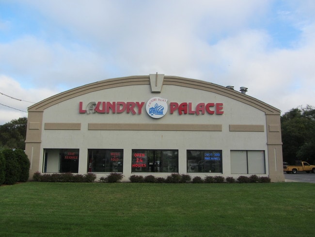
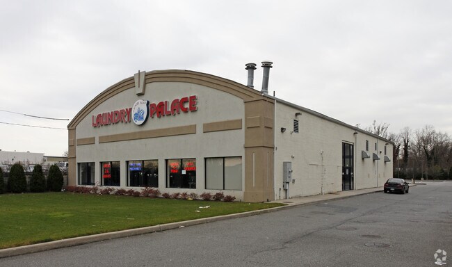
Property Record
1429 Sunrise Hwy, Bay Shore, NY 11706

Property Detail
1429 Sunrise Hwy
Nassau County-Suffolk County, NY
X2206416Y186605 N039N00000000
0500-315-00-03-00-047-000
Suffolk
Commercialnec
New York
BUS3
300
B and X Area of moderate flood hazard, usually the area between the limits of the 100-year and 500-year floods.
1.80 AC
0
Southwestern Suffolk
2024
Long Island (New York)
123701
NEARBY LISTINGS FOR SALE OR LEASE
DEMOGRAPHICS near 1429 Sunrise Hwy
1 mile
3 mile
5 mile
2024 Total Population
17,141
105,923
260,603
2029 Population
16,750
103,533
255,043
Pop Growth 2024-2029
(2.28%)
(2.26%)
(2.13%)
Average Age
38
39
40
2024 Total Households
5,507
31,810
77,290
HH Growth 2024-2029
(2.25%)
(2.26%)
(2.20%)
Median Household Inc
$94,627
$120,200
$124,462
Avg Household Size
3.00
3.10
3.20
2024 Avg HH Vehicles
2.00
2.00
2.00
Median Home Value
$464,725
$531,095
$537,162
Median Year Built
1964
1962
1963
Nearby Places
Map Layers
Map Styles
 Street
 Aerial
Transit
 Traffic
 Biking
Places
Listings with unknown addresses are not visible on the map
- Restaurants
- Banks
- Shops
- Fitness
- Groceries
PUBLIC TRANSPORTATION
COMMUTER RAIL
Bay Shore Station (Montauk Branch - Long Island Rail Road)
Drive
Walk
Distance
Bay Shore Station (Montauk Branch - Long Island Rail Road)
5 min
1.8 mi
Islip Station (Montauk Branch - Long Island Rail Road)
Drive
Walk
Distance
Islip Station (Montauk Branch - Long Island Rail Road)
8 min
4.0 mi
AIRPORT
Long Island MacArthur
Drive
Walk
Distance
Long Island MacArthur
21 min
12.5 mi
John F Kennedy International
Drive
Walk
Distance
John F Kennedy International
43 min
31.9 mi
LaGuardia
Drive
Walk
Distance
LaGuardia
54 min
38.9 mi
Freight Ports
NY - Red Hook Container Terminal
Drive
Walk
Distance
NY - Red Hook Container Terminal
64 min
43.3 mi
Nearby Properties
Address
Land Use
TOTAL SIZE
Lot Size
Zoning
Address
Land Use
TOTAL SIZE
Lot Size
Zoning
86.63 AC
Address
Land Use
TOTAL SIZE
Lot Size
Zoning
18.89 AC
Address
Land Use
TOTAL SIZE
Lot Size
Zoning
194.82 AC
AAA
Address
Land Use
TOTAL SIZE
Lot Size
Zoning
57.30 AC
IND1
Address
Land Use
TOTAL SIZE
Lot Size
Zoning
52.73 AC
AAA
Address
Land Use
TOTAL SIZE
Lot Size
Zoning
28.40 AC
A
Address
Land Use
TOTAL SIZE
Lot Size
Zoning
1,400 SF
10.27 AC
BD
Address
Land Use
TOTAL SIZE
Lot Size
Zoning
15 AC
B
Address
Land Use
TOTAL SIZE
Lot Size
Zoning
12 AC
A
Address
Land Use
TOTAL SIZE
Lot Size
Zoning
15.60 AC
BUS3
Address
Land Use
TOTAL SIZE
Lot Size
Zoning
16.23 AC
A
Address
Land Use
TOTAL SIZE
Lot Size
Zoning
19.56 AC
BUS3
Address
Land Use
TOTAL SIZE
Lot Size
Zoning
31.64 AC
Address
Land Use
TOTAL SIZE
Lot Size
Zoning
15 AC
A
Address
Land Use
TOTAL SIZE
Lot Size
Zoning
10.74 AC
Address
Land Use
TOTAL SIZE
Lot Size
Zoning
231.30 AC
AAA
Address
Land Use
TOTAL SIZE
Lot Size
Zoning
14.08 AC
Address
Land Use
TOTAL SIZE
Lot Size
Zoning
16.52 AC
AA
Address
Land Use
TOTAL SIZE
Lot Size
Zoning
19.60 AC
BUS3
Address
Land Use
TOTAL SIZE
Lot Size
Zoning
10.90 AC
B
Address
Land Use
TOTAL SIZE
Lot Size
Zoning
19.04 AC
BUS1
Address
Land Use
TOTAL SIZE
Lot Size
Zoning
10.44 AC
BUS3
Address
Land Use
TOTAL SIZE
Lot Size
Zoning
13.50 AC
AA
Address
Land Use
TOTAL SIZE
Lot Size
Zoning
9.70 AC
B
Address
Land Use
TOTAL SIZE
Lot Size
Zoning
46.60 AC
A
Address
Land Use
TOTAL SIZE
Lot Size
Zoning
6.66 AC
A
Address
Land Use
TOTAL SIZE
Lot Size
Zoning
10.38 AC
BUS1
Address
Land Use
TOTAL SIZE
Lot Size
Zoning
19.70 AC
B
Address
Land Use
TOTAL SIZE
Lot Size
Zoning
1.80 AC
Address
Land Use
TOTAL SIZE
Lot Size
Zoning
9.80 AC
AA
The World's #1 Commercial Real Estate Marketplace
Connect with us
© 2026 CoStar Group
The information above has been obtained from sources believed reliable. While we do not doubt its accuracy we have not verified it and make no guarantee, warranty or representation about it. It is your responsibility to independently confirm its accuracy and completeness. Any projections, opinions, assumptions, or estimates used are for example only and do not represent the current or future performance of the property. The value of this transaction to you depends on tax and other factors which should be evaluated by your tax, financial, and legal advisors. You and your advisors should conduct a careful, independent investigation of the property to determine to your satisfaction the suitability of the property for your needs.