Property Record
13-01 Pollitt Dr, Fair Lawn, NJ 07410

NEARBY LISTINGS FOR SALE OR LEASE
Property Detail
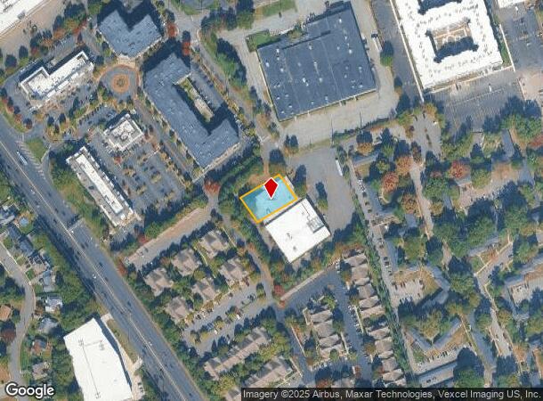
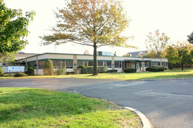
13-01 Pollitt Dr
New York-Jersey City-White Plains, NY-NJ
13-01 Pollitt Center
17-04702-0000-00002-0000-C0002
CE 39.45%
Industrialgeneral
Bergen
X
New Jersey
34003C0178H
2
2024
0.27 AC
2025
Northwest Bergen
018200
Northern New Jersey
DEMOGRAPHICS near 13-01 Pollitt Dr
1 Mile
3 Mile
5 Mile
2024 Total Population
17,825
205,703
486,894
2029 Population
17,205
199,571
474,316
Pop Growth 2024-2029
(3.48%)
(2.98%)
(2.58%)
Average Age
41
39
40
2024 Total Households
6,420
69,243
162,797
HH Growth 2024-2029
(3.80%)
(3.08%)
(2.68%)
Median Household Inc
$128,479
$77,896
$86,272
Avg Household Size
2.70
2.90
2.90
2024 Avg HH Vehicles
2.00
2.00
2.00
Median Home Value
$499,477
$488,283
$493,174
Median Year Built
1952
1952
1954
Nearby Places
Map Layers
Map Styles
 Street
 Aerial
- Restaurants
- Banks
- Shops
- Fitness
- Groceries
PUBLIC TRANSPORTATION
COMMUTER RAIL
Radburn (Bergen County/Port Jervis Line - NJ Transit Commuter Rail (NJ Transit))
DRIVE
WALK
Distance
Radburn (Bergen County/Port Jervis Line - NJ Transit Commuter Rail (NJ Transit))
5 min
15 min
0.8 mi
Glen Rock Boro Hall (Bergen County/Port Jervis Line - NJ Transit Commuter Rail (NJ Transit))
DRIVE
WALK
Distance
Glen Rock Boro Hall (Bergen County/Port Jervis Line - NJ Transit Commuter Rail (NJ Transit))
6 min
2.0 mi
AIRPORT
LaGuardia
DRIVE
WALK
Distance
LaGuardia
38 min
23.4 mi
Newark Liberty International
DRIVE
WALK
Distance
Newark Liberty International
32 min
23.7 mi
Westchester County
DRIVE
WALK
Distance
Westchester County
58 min
39.1 mi
Freight Ports
Port Newark Container Terminal
DRIVE
WALK
Distance
Port Newark Container Terminal
37 min
22.7 mi
SALE & LEASE HISTORY
LISTING DATE
SALE/LEASE

Nov 22, 2017
For Lease
Nearby Properties
Address
Land Use
TOTAL SIZE
Lot Size
Zoning
Address
Land Use
TOTAL SIZE
Lot Size
Zoning
466,866 SF
154.93 AC
R150
Address
Land Use
TOTAL SIZE
Lot Size
Zoning
7,060 SF
115.84 AC
HP
Address
Land Use
TOTAL SIZE
Lot Size
Zoning
8.66 AC
CH1
Address
Land Use
TOTAL SIZE
Lot Size
Zoning
164,588 SF
14.60 AC
BG
Address
Land Use
TOTAL SIZE
Lot Size
Zoning
259,273 SF
19.77 AC
BIL
Address
Land Use
TOTAL SIZE
Lot Size
Zoning
12,268 SF
98 AC
CR
Address
Land Use
TOTAL SIZE
Lot Size
Zoning
26,816 SF
25.50 AC
POP
Address
Land Use
TOTAL SIZE
Lot Size
Zoning
242,048 SF
25.40 AC
BLL
Address
Land Use
TOTAL SIZE
Lot Size
Zoning
9.96 AC
MU
Address
Land Use
TOTAL SIZE
Lot Size
Zoning
Address
Land Use
TOTAL SIZE
Lot Size
Zoning
57,680 SF
20.01 AC
CR
Address
Land Use
TOTAL SIZE
Lot Size
Zoning
33,222 SF
243.85 AC
RGC
Address
Land Use
TOTAL SIZE
Lot Size
Zoning
7.83 AC
Address
Land Use
TOTAL SIZE
Lot Size
Zoning
127,333 SF
8.30 AC
R100
Address
Land Use
TOTAL SIZE
Lot Size
Zoning
116,670 SF
13.79 AC
BIL
Address
Land Use
TOTAL SIZE
Lot Size
Zoning
1.80 AC
Address
Land Use
TOTAL SIZE
Lot Size
Zoning
824,024 SF
39.71 AC
I1
Address
Land Use
TOTAL SIZE
Lot Size
Zoning
90.48 AC
Address
Land Use
TOTAL SIZE
Lot Size
Zoning
157,100 SF
11.84 AC
BG
Address
Land Use
TOTAL SIZE
Lot Size
Zoning
210,907 SF
10 AC
R100
Address
Land Use
TOTAL SIZE
Lot Size
Zoning
Address
Land Use
TOTAL SIZE
Lot Size
Zoning
5.88 AC
Address
Land Use
TOTAL SIZE
Lot Size
Zoning
9.58 AC
R125
Address
Land Use
TOTAL SIZE
Lot Size
Zoning
117,101 SF
25.06 AC
R100
Address
Land Use
TOTAL SIZE
Lot Size
Zoning
59.45 AC
R100
Address
Land Use
TOTAL SIZE
Lot Size
Zoning
27.25 AC
Address
Land Use
TOTAL SIZE
Lot Size
Zoning
61,612 SF
5.58 AC
BL
Address
Land Use
TOTAL SIZE
Lot Size
Zoning
2.67 AC
AH2
Address
Land Use
TOTAL SIZE
Lot Size
Zoning
Address
Land Use
TOTAL SIZE
Lot Size
Zoning
11.87 AC
The World's #1 Commercial Real Estate Marketplace
Connect with us
© 2025 CoStar Group
The information above has been obtained from sources believed reliable. While we do not doubt its accuracy we have not verified it and make no guarantee, warranty or representation about it. It is your responsibility to independently confirm its accuracy and completeness. Any projections, opinions, assumptions, or estimates used are for example only and do not represent the current or future performance of the property. The value of this transaction to you depends on tax and other factors which should be evaluated by your tax, financial, and legal advisors. You and your advisors should conduct a careful, independent investigation of the property to determine to your satisfaction the suitability of the property for your needs.