Property Record
2163 Eagle Dr, Pagosa Springs, CO 81147


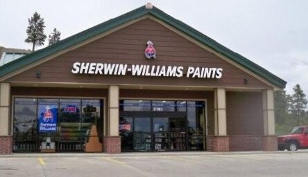
Property Detail
2163 Eagle Dr
569915221004
SUBDIVISION: MAJESTIC MINOR LOT: 2AX MM SEC: 15 TWN: 35 RNG: 2W
Storebuilding
Archuleta
MIXED-USE
Colorado
B and X Area of moderate flood hazard, usually the area between the limits of the 100-year and 500-year floods.
2a
2025
0.90 AC
2025
Colorado Southwest Area
974400
Other Market Areas
4,992 SF
NEARBY LISTINGS FOR SALE OR LEASE
DEMOGRAPHICS near 2163 Eagle Dr
1 mile
3 mile
5 mile
2024 Total Population
702
5,964
8,830
2029 Population
731
6,180
9,091
Pop Growth 2024-2029
+ 4.13%
+ 3.62%
+ 2.96%
Average Age
46
47
46
2024 Total Households
314
2,639
3,818
HH Growth 2024-2029
+ 4.14%
+ 3.75%
+ 3.06%
Median Household Inc
$61,500
$78,291
$81,142
Avg Household Size
2.20
2.20
2.30
2024 Avg HH Vehicles
2.00
2.00
2.00
Median Home Value
$526,667
$474,727
$472,836
Median Year Built
1993
1994
1995
Nearby Places
Map Layers
Map Styles
 Street
 Aerial
Transit
 Traffic
 Biking
Places
Listings with unknown addresses are not visible on the map
- Restaurants
- Banks
- Shops
- Fitness
- Groceries
Nearby Properties
Address
Land Use
TOTAL SIZE
Lot Size
Zoning
Address
Land Use
TOTAL SIZE
Lot Size
Zoning
4.54 AC
MIXED-USE
Address
Land Use
TOTAL SIZE
Lot Size
Zoning
6,748 SF
1.66 AC
MIXED-USE
Address
Land Use
TOTAL SIZE
Lot Size
Zoning
8,155 SF
3 AC
MIXED-USE
Address
Land Use
TOTAL SIZE
Lot Size
Zoning
2.66 AC
MIXED-USE
Address
Land Use
TOTAL SIZE
Lot Size
Zoning
77.55 AC
PUBLIC/QUA
Address
Land Use
TOTAL SIZE
Lot Size
Zoning
10.61 AC
MIXED-USE
Address
Land Use
TOTAL SIZE
Lot Size
Zoning
35,811 SF
3 AC
MIXED-USE
Address
Land Use
TOTAL SIZE
Lot Size
Zoning
27,645 SF
5.03 AC
MIXED-USE
Address
Land Use
TOTAL SIZE
Lot Size
Zoning
47,570 SF
6.97 AC
PUBLIC/QUA
Address
Land Use
TOTAL SIZE
Lot Size
Zoning
38,414 SF
13.63 AC
MIXED-USE
Address
Land Use
TOTAL SIZE
Lot Size
Zoning
19.34 AC
MIXED-USE
Address
Land Use
TOTAL SIZE
Lot Size
Zoning
15,960 SF
362.64 AC
INDUSTRIAL
Address
Land Use
TOTAL SIZE
Lot Size
Zoning
3,316 SF
1.21 AC
MIXED-USE
Address
Land Use
TOTAL SIZE
Lot Size
Zoning
2,690 SF
4.98 AC
MIXED-USE
Address
Land Use
TOTAL SIZE
Lot Size
Zoning
22,125 SF
3.57 AC
MIXED-USE
Address
Land Use
TOTAL SIZE
Lot Size
Zoning
13,024 SF
2.78 AC
COMMERCIAL
Address
Land Use
TOTAL SIZE
Lot Size
Zoning
37,750 SF
4.52 AC
PLANNED UN
Address
Land Use
TOTAL SIZE
Lot Size
Zoning
11,010 SF
14.53 AC
PUBLIC/QUA
Address
Land Use
TOTAL SIZE
Lot Size
Zoning
18,693 SF
1.36 AC
MIXED-USE
Address
Land Use
TOTAL SIZE
Lot Size
Zoning
15,857 SF
0.63 AC
MIXED-USE
Address
Land Use
TOTAL SIZE
Lot Size
Zoning
22,540 SF
4.78 AC
MIXED-USE
Address
Land Use
TOTAL SIZE
Lot Size
Zoning
110 AC
OPEN SPACE
Address
Land Use
TOTAL SIZE
Lot Size
Zoning
1.37 AC
MIXED-USE
Address
Land Use
TOTAL SIZE
Lot Size
Zoning
1.08 AC
PLANNED UN
Address
Land Use
TOTAL SIZE
Lot Size
Zoning
16,000 SF
6 AC
MIXED-USE
Address
Land Use
TOTAL SIZE
Lot Size
Zoning
20,922 SF
1.04 AC
MIXED-USE
Address
Land Use
TOTAL SIZE
Lot Size
Zoning
4.10 AC
MIXED-USE
Address
Land Use
TOTAL SIZE
Lot Size
Zoning
1.08 AC
PLANNED UN
Address
Land Use
TOTAL SIZE
Lot Size
Zoning
280 SF
88.92 AC
MIXED USE
Address
Land Use
TOTAL SIZE
Lot Size
Zoning
13,601 SF
2.53 AC
COMMERCIAL
The World's #1 Commercial Real Estate Marketplace
Connect with us
© 2026 CoStar Group
The information above has been obtained from sources believed reliable. While we do not doubt its accuracy we have not verified it and make no guarantee, warranty or representation about it. It is your responsibility to independently confirm its accuracy and completeness. Any projections, opinions, assumptions, or estimates used are for example only and do not represent the current or future performance of the property. The value of this transaction to you depends on tax and other factors which should be evaluated by your tax, financial, and legal advisors. You and your advisors should conduct a careful, independent investigation of the property to determine to your satisfaction the suitability of the property for your needs.