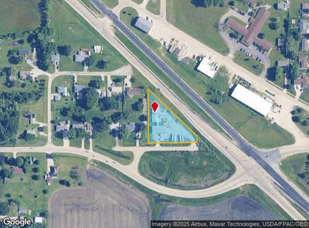
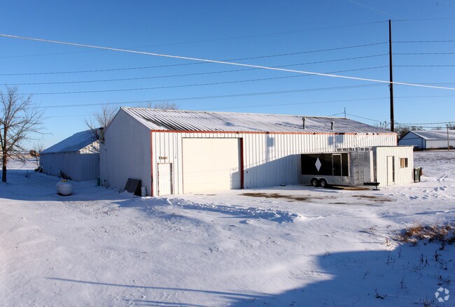
Property Record
33131 190Th St, Granger, IA 50109

Property Detail
33131 190Th St
08-01-353-011
S308.85 E280.26 W859.24 LYG S & W OF HWY SW SW
Officebuilding
Dallas
X
Iowa
19015C0475D
1.13 AC
2024
Outlying Dallas County
2025
Des Moines
050100
Des Moines-West Des Moines, IA
7,816 SF
NEARBY LISTINGS FOR SALE OR LEASE
DEMOGRAPHICS near 33131 190Th St
1 mile
3 mile
5 mile
2024 Total Population
1,804
3,584
11,013
2029 Population
2,201
4,154
12,108
Pop Growth 2024-2029
+ 22.01%
+ 15.90%
+ 9.94%
Average Age
39
38
36
2024 Total Households
666
1,268
3,830
HH Growth 2024-2029
+ 22.97%
+ 16.88%
+ 10.50%
Median Household Inc
$106,720
$113,973
$113,776
Avg Household Size
2.70
2.80
2.90
2024 Avg HH Vehicles
2.00
2.00
2.00
Median Home Value
$257,601
$301,316
$331,974
Median Year Built
2004
2003
2005
Nearby Places
Map Layers
Map Styles
 Street
 Aerial
Transit
 Traffic
 Biking
Places
Listings with unknown addresses are not visible on the map
- Restaurants
- Banks
- Shops
- Fitness
- Groceries
PUBLIC TRANSPORTATION
AIRPORT
Des Moines International
Drive
Walk
Distance
Des Moines International
37 min
23.6 mi
Freight Ports
Port Milwaukee
Drive
Walk
Distance
Port Milwaukee
433 min
387.9 mi
Nearby Properties
Address
Land Use
TOTAL SIZE
Lot Size
Zoning
Address
Land Use
TOTAL SIZE
Lot Size
Zoning
2.44 AC
Address
Land Use
TOTAL SIZE
Lot Size
Zoning
8,100 SF
16.99 AC
Address
Land Use
TOTAL SIZE
Lot Size
Zoning
24,320 SF
4.14 AC
Address
Land Use
TOTAL SIZE
Lot Size
Zoning
3,402 SF
5.93 AC
Address
Land Use
TOTAL SIZE
Lot Size
Zoning
8,738 SF
29.38 AC
Address
Land Use
TOTAL SIZE
Lot Size
Zoning
3.46 AC
Address
Land Use
TOTAL SIZE
Lot Size
Zoning
24,300 SF
3.40 AC
Address
Land Use
TOTAL SIZE
Lot Size
Zoning
24,374 SF
11.99 AC
Address
Land Use
TOTAL SIZE
Lot Size
Zoning
2,750 SF
9.30 AC
Address
Land Use
TOTAL SIZE
Lot Size
Zoning
20,754 SF
4 AC
Address
Land Use
TOTAL SIZE
Lot Size
Zoning
9,120 SF
5.81 AC
Address
Land Use
TOTAL SIZE
Lot Size
Zoning
7,970 SF
2.87 AC
Address
Land Use
TOTAL SIZE
Lot Size
Zoning
11,412 SF
6.52 AC
Address
Land Use
TOTAL SIZE
Lot Size
Zoning
7,068 SF
19.67 AC
Address
Land Use
TOTAL SIZE
Lot Size
Zoning
8,957 SF
2.94 AC
Address
Land Use
TOTAL SIZE
Lot Size
Zoning
2.65 AC
Address
Land Use
TOTAL SIZE
Lot Size
Zoning
7,632 SF
5.65 AC
Address
Land Use
TOTAL SIZE
Lot Size
Zoning
20,480 SF
Address
Land Use
TOTAL SIZE
Lot Size
Zoning
7,168 SF
11.37 AC
Address
Land Use
TOTAL SIZE
Lot Size
Zoning
8,414 SF
3.97 AC
Address
Land Use
TOTAL SIZE
Lot Size
Zoning
3,362 SF
2.36 AC
Address
Land Use
TOTAL SIZE
Lot Size
Zoning
6,534 SF
12.08 AC
Address
Land Use
TOTAL SIZE
Lot Size
Zoning
6,059 SF
9.40 AC
Address
Land Use
TOTAL SIZE
Lot Size
Zoning
7,024 SF
6.56 AC
Address
Land Use
TOTAL SIZE
Lot Size
Zoning
10,080 SF
15.34 AC
Address
Land Use
TOTAL SIZE
Lot Size
Zoning
11,997 SF
9.69 AC
Address
Land Use
TOTAL SIZE
Lot Size
Zoning
6,916 SF
39.39 AC
Address
Land Use
TOTAL SIZE
Lot Size
Zoning
6,012 SF
4.89 AC
Address
Land Use
TOTAL SIZE
Lot Size
Zoning
3,024 SF
2.70 AC
The World's #1 Commercial Real Estate Marketplace
Connect with us
© 2026 CoStar Group
The information above has been obtained from sources believed reliable. While we do not doubt its accuracy we have not verified it and make no guarantee, warranty or representation about it. It is your responsibility to independently confirm its accuracy and completeness. Any projections, opinions, assumptions, or estimates used are for example only and do not represent the current or future performance of the property. The value of this transaction to you depends on tax and other factors which should be evaluated by your tax, financial, and legal advisors. You and your advisors should conduct a careful, independent investigation of the property to determine to your satisfaction the suitability of the property for your needs.