Property Record
143 Route 2A, Preston, CT 06365

Save to a Folder
{{folder.Name}}
{{folder.ListingIds.length}} Properties
{{folder.ListingIds.length}} Property
Create a New Folder
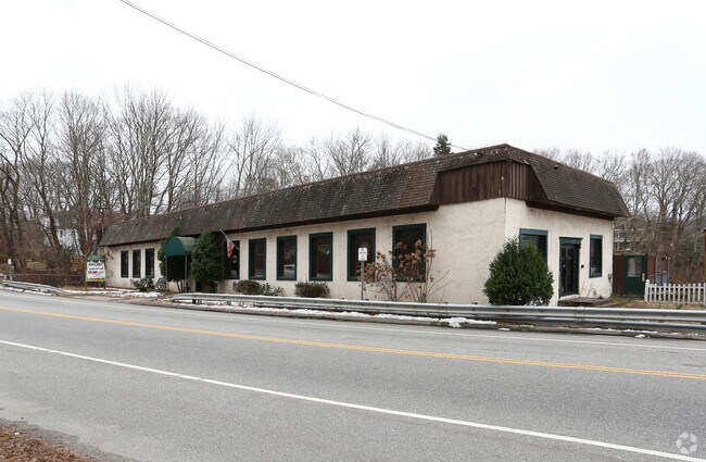
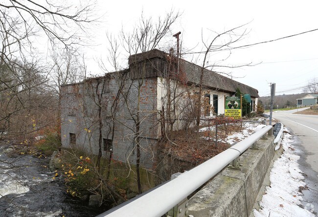
Property Detail
143 Route 2A
PRES-000220-A000002-000143
Southeastern Ct
Commercialbuilding
Connecticut
C
143
AE The base floodplain where base flood elevations are provided. AE Zones are now used on new format FIRMs instead of A1-A30 Zones.
1 AC
2024
NE New London/Norwich
2025
Hartford
700100
Norwich-New London-Willimantic, CT
5,100 SF
NEARBY LISTINGS FOR SALE OR LEASE
DEMOGRAPHICS near 143 Route 2A
1 mile
3 mile
5 mile
2025 Total Population
1,275
13,078
51,045
2030 Population
1,291
13,214
51,460
Pop Growth 2025-2030
+ 1.25%
+ 1.04%
+ 0.81%
Average Age
43
41
41
2025 Total Households
496
5,286
20,394
HH Growth 2025-2030
+ 1.01%
+ 0.89%
+ 0.77%
Median Household Inc
$109,337
$83,032
$77,115
Avg Household Size
2.50
2.40
2.40
2025 Avg HH Vehicles
2.00
2.00
2.00
Median Home Value
$323,077
$274,551
$271,147
Median Year Built
1962
1962
1962
Nearby Places
Map Layers
Map Styles
 Street
 Aerial
Layers
 Traffic
 Biking
Places
Listings with unknown addresses are not visible on the map
- Restaurants
- Banks
- Shops
- Fitness
- Groceries
Nearby Properties
Address
Land Use
TOTAL SIZE
Lot Size
Zoning
Address
Land Use
TOTAL SIZE
Lot Size
Zoning
242 AC
R20
Address
Land Use
TOTAL SIZE
Lot Size
Zoning
4.59 AC
TRDD
Address
Land Use
TOTAL SIZE
Lot Size
Zoning
2,102 SF
110.90 AC
PDD
Address
Land Use
TOTAL SIZE
Lot Size
Zoning
65.90 AC
RSRVT
Address
Land Use
TOTAL SIZE
Lot Size
Zoning
16,551 SF
18.11 AC
MF
Address
Land Use
TOTAL SIZE
Lot Size
Zoning
59.03 AC
RSRVT
Address
Land Use
TOTAL SIZE
Lot Size
Zoning
102,477 SF
22.51 AC
C-2
Address
Land Use
TOTAL SIZE
Lot Size
Zoning
38.30 AC
R40
Address
Land Use
TOTAL SIZE
Lot Size
Zoning
106,807 SF
5.60 AC
C-2
Address
Land Use
TOTAL SIZE
Lot Size
Zoning
6.39 AC
MF
Address
Land Use
TOTAL SIZE
Lot Size
Zoning
15,208 SF
205.14 AC
TRDD
Address
Land Use
TOTAL SIZE
Lot Size
Zoning
58,636 SF
2.73 AC
C-2
Address
Land Use
TOTAL SIZE
Lot Size
Zoning
23.24 AC
RSRVT
Address
Land Use
TOTAL SIZE
Lot Size
Zoning
10.95 AC
PC
Address
Land Use
TOTAL SIZE
Lot Size
Zoning
78,364 SF
4.88 AC
GC
Address
Land Use
TOTAL SIZE
Lot Size
Zoning
55,562 SF
29.68 AC
GOV
Address
Land Use
TOTAL SIZE
Lot Size
Zoning
12.65 AC
R20
Address
Land Use
TOTAL SIZE
Lot Size
Zoning
18.90 AC
RSRVT
Address
Land Use
TOTAL SIZE
Lot Size
Zoning
3,980 SF
28.50 AC
MF
Address
Land Use
TOTAL SIZE
Lot Size
Zoning
55,321 SF
WD
Address
Land Use
TOTAL SIZE
Lot Size
Zoning
38,127 SF
0.93 AC
MF
Address
Land Use
TOTAL SIZE
Lot Size
Zoning
43,142 SF
7.33 AC
MF
Address
Land Use
TOTAL SIZE
Lot Size
Zoning
44,927 SF
0.37 AC
CC
Address
Land Use
TOTAL SIZE
Lot Size
Zoning
37,286 SF
12.26 AC
R20
Address
Land Use
TOTAL SIZE
Lot Size
Zoning
10.46 AC
RSRVT
Address
Land Use
TOTAL SIZE
Lot Size
Zoning
74.09 AC
TRDD
Address
Land Use
TOTAL SIZE
Lot Size
Zoning
12,950 SF
3.30 AC
C-1
Address
Land Use
TOTAL SIZE
Lot Size
Zoning
6 AC
GC
Address
Land Use
TOTAL SIZE
Lot Size
Zoning
1,449 SF
3.13 AC
MF
Address
Land Use
TOTAL SIZE
Lot Size
Zoning
12.40 AC
RSRVT
The World's #1 Commercial Real Estate Marketplace
Connect with us
© 2026 CoStar Group
The information above has been obtained from sources believed reliable. While we do not doubt its accuracy we have not verified it and make no guarantee, warranty or representation about it. It is your responsibility to independently confirm its accuracy and completeness. Any projections, opinions, assumptions, or estimates used are for example only and do not represent the current or future performance of the property. The value of this transaction to you depends on tax and other factors which should be evaluated by your tax, financial, and legal advisors. You and your advisors should conduct a careful, independent investigation of the property to determine to your satisfaction the suitability of the property for your needs.