Property Record
165 Eads St, West Babylon, NY 11704

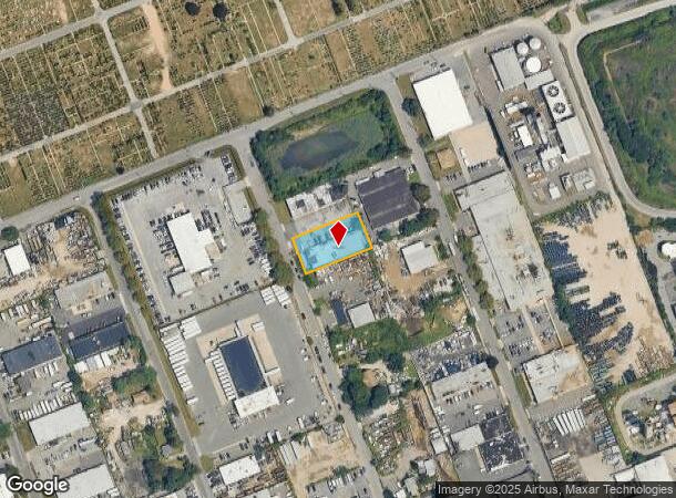
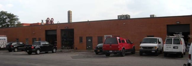

Property Detail
165 Eads St
Nassau County-Suffolk County, NY
Map Western Division Squaw Pit Purchase
0100-073-00-02-00-022-001
FILED MAP 425 LOT S.PT. 165
Industrialgeneral
Suffolk
X
New York
36103C0835H
22
2024
0.43 AC
2024
Deer Park
122408
Long Island (New York)
8,100 SF
NEARBY LISTINGS FOR SALE OR LEASE
DEMOGRAPHICS near 165 Eads St
1 mile
3 mile
5 mile
2024 Total Population
1,190
103,947
319,753
2029 Population
1,151
101,514
313,056
Pop Growth 2024-2029
(3.28%)
(2.34%)
(2.09%)
Average Age
38
40
41
2024 Total Households
329
32,463
105,849
HH Growth 2024-2029
(3.65%)
(2.53%)
(2.27%)
Median Household Inc
$109,042
$112,886
$115,468
Avg Household Size
3.40
3.00
2.90
2024 Avg HH Vehicles
2.00
2.00
2.00
Median Home Value
$427,272
$451,871
$487,040
Median Year Built
1954
1963
1960
Nearby Places
Map Layers
Map Styles
 Street
 Aerial
Transit
 Traffic
 Biking
Places
Listings with unknown addresses are not visible on the map
- Restaurants
- Banks
- Shops
- Fitness
- Groceries
PUBLIC TRANSPORTATION
COMMUTER RAIL
Pinelawn Station (Ronkonkoma Branch - Long Island Rail Road)
Drive
Walk
Distance
Pinelawn Station (Ronkonkoma Branch - Long Island Rail Road)
4 min
1.4 mi
Wyandanch Station (Ronkonkoma Branch - Long Island Rail Road)
Drive
Walk
Distance
Wyandanch Station (Ronkonkoma Branch - Long Island Rail Road)
7 min
2.9 mi
AIRPORT
Long Island MacArthur
Drive
Walk
Distance
Long Island MacArthur
32 min
21.1 mi
John F Kennedy International
Drive
Walk
Distance
John F Kennedy International
39 min
26.7 mi
LaGuardia
Drive
Walk
Distance
LaGuardia
49 min
33.6 mi
Freight Ports
NY - Red Hook Container Terminal
Drive
Walk
Distance
NY - Red Hook Container Terminal
59 min
38.1 mi
SALE & LEASE HISTORY
LISTING DATE
SALE/LEASE

Apr 13, 2017
For Lease
Nearby Properties
Address
Land Use
TOTAL SIZE
Lot Size
Zoning
Address
Land Use
TOTAL SIZE
Lot Size
Zoning
2,131 SF
0.64 AC
R20
Address
Land Use
TOTAL SIZE
Lot Size
Zoning
2,304 SF
4.26 AC
R80
Address
Land Use
TOTAL SIZE
Lot Size
Zoning
3,351 SF
1.99 AC
R40
Address
Land Use
TOTAL SIZE
Lot Size
Zoning
3,898 SF
0.90 AC
R40
Address
Land Use
TOTAL SIZE
Lot Size
Zoning
3,366 SF
0.64 AC
R40
Address
Land Use
TOTAL SIZE
Lot Size
Zoning
4,571 SF
1.21 AC
R40
Address
Land Use
TOTAL SIZE
Lot Size
Zoning
756 SF
0.36 AC
B1
Address
Land Use
TOTAL SIZE
Lot Size
Zoning
37 AC
I2
Address
Land Use
TOTAL SIZE
Lot Size
Zoning
3,747 SF
1.10 AC
CR80
Address
Land Use
TOTAL SIZE
Lot Size
Zoning
24.90 AC
B
Address
Land Use
TOTAL SIZE
Lot Size
Zoning
2,384 SF
1.44 AC
R40
Address
Land Use
TOTAL SIZE
Lot Size
Zoning
3.31 AC
R40
Address
Land Use
TOTAL SIZE
Lot Size
Zoning
2,062 SF
0.89 AC
R40
Address
Land Use
TOTAL SIZE
Lot Size
Zoning
3,105 SF
1.05 AC
CR80
Address
Land Use
TOTAL SIZE
Lot Size
Zoning
3,304 SF
1 AC
CR80
Address
Land Use
TOTAL SIZE
Lot Size
Zoning
3,562 SF
1.44 AC
CR80
Address
Land Use
TOTAL SIZE
Lot Size
Zoning
2,097 SF
0.24 AC
R20
Address
Land Use
TOTAL SIZE
Lot Size
Zoning
6.37 AC
BUS3
Address
Land Use
TOTAL SIZE
Lot Size
Zoning
2,324 SF
0.36 AC
R2
Address
Land Use
TOTAL SIZE
Lot Size
Zoning
1,407 SF
0.35 AC
R40
Address
Land Use
TOTAL SIZE
Lot Size
Zoning
16.71 AC
GSF
Address
Land Use
TOTAL SIZE
Lot Size
Zoning
1,390 SF
0.17 AC
R10
Address
Land Use
TOTAL SIZE
Lot Size
Zoning
2,603 SF
1.41 AC
CR120
Address
Land Use
TOTAL SIZE
Lot Size
Zoning
1,908 SF
0.45 AC
R40
Address
Land Use
TOTAL SIZE
Lot Size
Zoning
77,270 SF
21.67 AC
Address
Land Use
TOTAL SIZE
Lot Size
Zoning
1,608 SF
0.28 AC
R2
Address
Land Use
TOTAL SIZE
Lot Size
Zoning
2,013 SF
0.23 AC
R15
Address
Land Use
TOTAL SIZE
Lot Size
Zoning
2,780 SF
0.43 AC
R20
Address
Land Use
TOTAL SIZE
Lot Size
Zoning
336,442 SF
43.50 AC
G
Address
Land Use
TOTAL SIZE
Lot Size
Zoning
850 SF
0.54 AC
R20
The World's #1 Commercial Real Estate Marketplace
Connect with us
© 2026 CoStar Group
The information above has been obtained from sources believed reliable. While we do not doubt its accuracy we have not verified it and make no guarantee, warranty or representation about it. It is your responsibility to independently confirm its accuracy and completeness. Any projections, opinions, assumptions, or estimates used are for example only and do not represent the current or future performance of the property. The value of this transaction to you depends on tax and other factors which should be evaluated by your tax, financial, and legal advisors. You and your advisors should conduct a careful, independent investigation of the property to determine to your satisfaction the suitability of the property for your needs.