Property Record
6016 Morgantown Rd, Morgantown, PA 19543
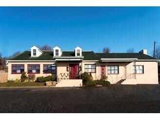

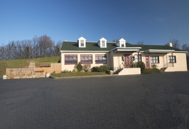

Property Detail
6016 Morgantown Rd
35-5320-01-08-3036
BERKS
Restaurantbuilding
Pennsylvania
B and X Area of moderate flood hazard, usually the area between the limits of the 100-year and 500-year floods.
1.10 AC
2025
Berks County
2025
Philadelphia
011703
Reading, PA
5,766 SF
NEARBY LISTINGS FOR SALE OR LEASE
-
-
View all Morgantown listings for sale on LoopNet.com
DEMOGRAPHICS near 6016 Morgantown Rd
1 mile
3 mile
5 mile
2025 Total Population
1,634
7,223
17,231
2030 Population
1,663
7,374
17,594
Pop Growth 2025-2030
+ 1.77%
+ 2.09%
+ 2.11%
Average Age
40
40
41
2025 Total Households
635
2,555
6,147
HH Growth 2025-2030
+ 1.73%
+ 2.23%
+ 2.26%
Median Household Inc
$89,273
$100,779
$99,262
Avg Household Size
2.60
2.80
2.80
2025 Avg HH Vehicles
2.00
2.00
2.00
Median Home Value
$273,849
$364,495
$383,658
Median Year Built
1988
1989
1986
Nearby Places
Map Layers
Map Styles
 Street
 Aerial
Transit
 Traffic
 Biking
Places
Listings with unknown addresses are not visible on the map
- Restaurants
- Banks
- Shops
- Fitness
- Groceries
PUBLIC TRANSPORTATION
AIRPORT
Philadelphia International
Drive
Walk
Distance
Philadelphia International
71 min
48.2 mi
Freight Ports
Port of Wilmington, RI
Drive
Walk
Distance
Port of Wilmington, RI
68 min
43.6 mi
Nearby Properties
Address
Land Use
TOTAL SIZE
Lot Size
Zoning
Address
Land Use
TOTAL SIZE
Lot Size
Zoning
90,332 SF
36.29 AC
Address
Land Use
TOTAL SIZE
Lot Size
Zoning
368,961 SF
64.31 AC
Address
Land Use
TOTAL SIZE
Lot Size
Zoning
471,523 SF
33.83 AC
Address
Land Use
TOTAL SIZE
Lot Size
Zoning
103,284 SF
49.74 AC
Address
Land Use
TOTAL SIZE
Lot Size
Zoning
12,080 SF
415.85 AC
Address
Land Use
TOTAL SIZE
Lot Size
Zoning
59,146 SF
7.36 AC
Address
Land Use
TOTAL SIZE
Lot Size
Zoning
78,456 SF
26.04 AC
VC
Address
Land Use
TOTAL SIZE
Lot Size
Zoning
180,400 SF
26.44 AC
Address
Land Use
TOTAL SIZE
Lot Size
Zoning
130,800 SF
14.06 AC
Address
Land Use
TOTAL SIZE
Lot Size
Zoning
244,220 SF
29.63 AC
Address
Land Use
TOTAL SIZE
Lot Size
Zoning
134,216 SF
10.13 AC
Address
Land Use
TOTAL SIZE
Lot Size
Zoning
40,760 SF
11.02 AC
Address
Land Use
TOTAL SIZE
Lot Size
Zoning
37,239 SF
7.13 AC
Address
Land Use
TOTAL SIZE
Lot Size
Zoning
206,685 SF
104.40 AC
Address
Land Use
TOTAL SIZE
Lot Size
Zoning
71,680 SF
6.61 AC
Address
Land Use
TOTAL SIZE
Lot Size
Zoning
25,518 SF
12.40 AC
AG
Address
Land Use
TOTAL SIZE
Lot Size
Zoning
122,958 SF
4.79 AC
A
Address
Land Use
TOTAL SIZE
Lot Size
Zoning
109,872 SF
7.90 AC
Address
Land Use
TOTAL SIZE
Lot Size
Zoning
339,481 SF
38.13 AC
Address
Land Use
TOTAL SIZE
Lot Size
Zoning
8,421 SF
177.70 AC
AG
Address
Land Use
TOTAL SIZE
Lot Size
Zoning
75,568 SF
5.28 AC
Address
Land Use
TOTAL SIZE
Lot Size
Zoning
54,952 SF
6.70 AC
Address
Land Use
TOTAL SIZE
Lot Size
Zoning
12,025 SF
156.80 AC
AG
Address
Land Use
TOTAL SIZE
Lot Size
Zoning
95,492 SF
44.45 AC
HCLI
Address
Land Use
TOTAL SIZE
Lot Size
Zoning
70,000 SF
8.95 AC
Address
Land Use
TOTAL SIZE
Lot Size
Zoning
23,431 SF
8.50 AC
Address
Land Use
TOTAL SIZE
Lot Size
Zoning
97,450 SF
10.07 AC
Address
Land Use
TOTAL SIZE
Lot Size
Zoning
73,605 SF
7.34 AC
Address
Land Use
TOTAL SIZE
Lot Size
Zoning
86,926 SF
9.08 AC
Address
Land Use
TOTAL SIZE
Lot Size
Zoning
1,980 SF
535.50 AC
The World's #1 Commercial Real Estate Marketplace
Connect with us
© 2026 CoStar Group
The information above has been obtained from sources believed reliable. While we do not doubt its accuracy we have not verified it and make no guarantee, warranty or representation about it. It is your responsibility to independently confirm its accuracy and completeness. Any projections, opinions, assumptions, or estimates used are for example only and do not represent the current or future performance of the property. The value of this transaction to you depends on tax and other factors which should be evaluated by your tax, financial, and legal advisors. You and your advisors should conduct a careful, independent investigation of the property to determine to your satisfaction the suitability of the property for your needs.