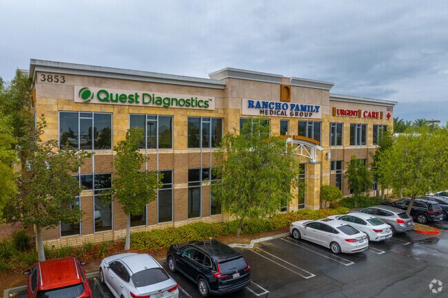
Property Record
3853 W Stetson Ave, Hemet, CA 92545


Property Detail
3853 W Stetson Ave
460-250-033
1.23 ACRES IN PAR 5 PM 225/079 PM 35701
Medicalbuilding
Riverside
PCD
California
C and X Area of minimal flood hazard, usually depicted on FIRMs as above the 500-year flood level.
5
2024
1.23 AC
2025
Beaumont/Hemet
043319
Inland Empire (California)
38,068 SF
Riverside-San Bernardino-Ontario, CA
NEARBY LISTINGS FOR SALE OR LEASE
DEMOGRAPHICS near 3853 W Stetson Ave
1 mile
3 mile
5 mile
2025 Total Population
11,376
71,970
146,828
2030 Population
11,595
74,302
151,485
Pop Growth 2025-2030
+ 1.93%
+ 3.24%
+ 3.17%
Average Age
42
42
39
2025 Total Households
3,828
26,519
48,396
HH Growth 2025-2030
+ 1.72%
+ 2.84%
+ 2.81%
Median Household Inc
$74,482
$54,452
$62,347
Avg Household Size
2.80
2.60
2.90
2025 Avg HH Vehicles
2.00
2.00
2.00
Median Home Value
$393,397
$314,724
$378,852
Median Year Built
1997
1983
1984
Nearby Places
Map Layers
Map Styles
 Street
 Aerial
Transit
 Traffic
 Biking
Places
Listings with unknown addresses are not visible on the map
- Restaurants
- Banks
- Shops
- Fitness
- Groceries
PUBLIC TRANSPORTATION
AIRPORT
Palm Springs International
Drive
Walk
Distance
Palm Springs International
57 min
46.8 mi
Freight Ports
Port of Long Beach
Drive
Walk
Distance
Port of Long Beach
111 min
85.5 mi
SALE & LEASE HISTORY
LISTING DATE
SALE/LEASE

Sep 25, 2016
For Lease
Nov 03, 2016
For Lease
Nearby Properties
Address
Land Use
TOTAL SIZE
Lot Size
Zoning
Address
Land Use
TOTAL SIZE
Lot Size
Zoning
850,640 SF
42.40 AC
Address
Land Use
TOTAL SIZE
Lot Size
Zoning
168,761 SF
20.67 AC
Address
Land Use
TOTAL SIZE
Lot Size
Zoning
4,550 SF
127.73 AC
Address
Land Use
TOTAL SIZE
Lot Size
Zoning
306,540 SF
7.69 AC
Address
Land Use
TOTAL SIZE
Lot Size
Zoning
94,476 SF
4.86 AC
R3
Address
Land Use
TOTAL SIZE
Lot Size
Zoning
165,401 SF
13.45 AC
C1
Address
Land Use
TOTAL SIZE
Lot Size
Zoning
459,613 SF
18.24 AC
Address
Land Use
TOTAL SIZE
Lot Size
Zoning
9,184 SF
4.75 AC
R3
Address
Land Use
TOTAL SIZE
Lot Size
Zoning
50,160 SF
5.93 AC
R3
Address
Land Use
TOTAL SIZE
Lot Size
Zoning
27,964 SF
5.47 AC
Address
Land Use
TOTAL SIZE
Lot Size
Zoning
53,140 SF
6.74 AC
C2
Address
Land Use
TOTAL SIZE
Lot Size
Zoning
89,317 SF
5.77 AC
Address
Land Use
TOTAL SIZE
Lot Size
Zoning
66,482 SF
9.11 AC
A1
Address
Land Use
TOTAL SIZE
Lot Size
Zoning
167,396 SF
9.36 AC
Address
Land Use
TOTAL SIZE
Lot Size
Zoning
44,600 SF
6.41 AC
Address
Land Use
TOTAL SIZE
Lot Size
Zoning
59,680 SF
5.80 AC
C2
Address
Land Use
TOTAL SIZE
Lot Size
Zoning
42,064 SF
4.71 AC
C1
Address
Land Use
TOTAL SIZE
Lot Size
Zoning
69,306 SF
6.02 AC
Address
Land Use
TOTAL SIZE
Lot Size
Zoning
101,172 SF
7.48 AC
Address
Land Use
TOTAL SIZE
Lot Size
Zoning
79,683 SF
7.97 AC
C1
Address
Land Use
TOTAL SIZE
Lot Size
Zoning
24,656 SF
4.32 AC
R3
Address
Land Use
TOTAL SIZE
Lot Size
Zoning
88,530 SF
18.41 AC
Address
Land Use
TOTAL SIZE
Lot Size
Zoning
202,852 SF
11.37 AC
Address
Land Use
TOTAL SIZE
Lot Size
Zoning
104,713 SF
7.49 AC
Address
Land Use
TOTAL SIZE
Lot Size
Zoning
100,155 SF
8.28 AC
Address
Land Use
TOTAL SIZE
Lot Size
Zoning
26,035 SF
6.90 AC
Address
Land Use
TOTAL SIZE
Lot Size
Zoning
299,341 SF
5.85 AC
C2
Address
Land Use
TOTAL SIZE
Lot Size
Zoning
33.74 AC
The World's #1 Commercial Real Estate Marketplace
Connect with us
© 2026 CoStar Group
The information above has been obtained from sources believed reliable. While we do not doubt its accuracy we have not verified it and make no guarantee, warranty or representation about it. It is your responsibility to independently confirm its accuracy and completeness. Any projections, opinions, assumptions, or estimates used are for example only and do not represent the current or future performance of the property. The value of this transaction to you depends on tax and other factors which should be evaluated by your tax, financial, and legal advisors. You and your advisors should conduct a careful, independent investigation of the property to determine to your satisfaction the suitability of the property for your needs.