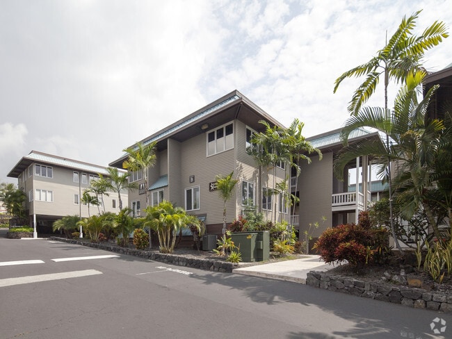
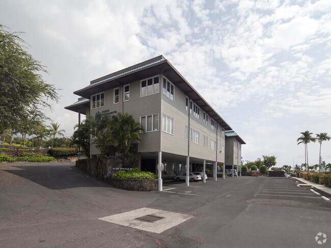
Property Record
75-377 Hualalai Rd, Kailua Kona, HI 96740
NEARBY LISTINGS FOR SALE OR LEASE
Property Detail
75-377 Hualalai Rd
Hilo-Kailua, HI
Hienaloli 1St - Hienaloli 6Th
3-7-5-008-030-0000
TOG/SEWER ESMT S-1 [4,141 SF] OVER TMK 7508-23
Commercialnec
Hawaii
X
Hawaii
1551660738F
4
2024
0.71 AC
2025
Kailua-Kona
021606
Hawaii
12,824 SF
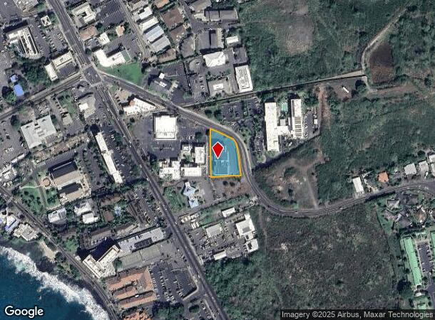
DEMOGRAPHICS near 75-377 Hualalai Rd
1 mile
3 mile
5 mile
2024 Total Population
6,573
21,747
28,443
2029 Population
6,993
22,871
29,980
Pop Growth 2024-2029
+ 6.39%
+ 5.17%
+ 5.40%
Average Age
44
43
43
2024 Total Households
2,650
8,114
10,509
HH Growth 2024-2029
+ 7.06%
+ 5.73%
+ 5.74%
Median Household Inc
$62,223
$78,397
$79,631
Avg Household Size
2.30
2.50
2.60
2024 Avg HH Vehicles
2.00
2.00
2.00
Median Home Value
$448,451
$658,429
$700,464
Median Year Built
1984
1986
1986
Nearby Places
Map Layers
Map Styles
 Street
 Aerial
Transit
 Traffic
 Biking
Places
Listings with unknown addresses are not visible on the map
- Restaurants
- Banks
- Shops
- Fitness
- Groceries
PUBLIC TRANSPORTATION
AIRPORT
Ellison Onizuka Kona International at Keahole
Drive
Walk
Distance
Ellison Onizuka Kona International at Keahole
20 min
9.1 mi
SALE & LEASE HISTORY
LISTING DATE
SALE/LEASE

Sep 24, 2016
For Lease
Nearby Properties
Address
Land Use
TOTAL SIZE
Lot Size
Zoning
Address
Land Use
TOTAL SIZE
Lot Size
Zoning
135,452 SF
10 AC
CG-10
Address
Land Use
TOTAL SIZE
Lot Size
Zoning
19.55 AC
CG-20
Address
Land Use
TOTAL SIZE
Lot Size
Zoning
4,135 SF
865.80 AC
MCX-20
Address
Land Use
TOTAL SIZE
Lot Size
Zoning
12,528 SF
10.33 AC
RS-15
Address
Land Use
TOTAL SIZE
Lot Size
Zoning
134,941 SF
5.43 AC
V-.75
Address
Land Use
TOTAL SIZE
Lot Size
Zoning
203.01 AC
CG-10
Address
Land Use
TOTAL SIZE
Lot Size
Zoning
129,257 SF
10.63 AC
MCX-20
Address
Land Use
TOTAL SIZE
Lot Size
Zoning
162,628 SF
11.02 AC
MCX-20
Address
Land Use
TOTAL SIZE
Lot Size
Zoning
101,191 SF
40.34 AC
RM-4
Address
Land Use
TOTAL SIZE
Lot Size
Zoning
140,367 SF
13.15 AC
CG-20
Address
Land Use
TOTAL SIZE
Lot Size
Zoning
13,137 SF
7 AC
OPEN
Address
Land Use
TOTAL SIZE
Lot Size
Zoning
133,724 SF
10.69 AC
CG-20
Address
Land Use
TOTAL SIZE
Lot Size
Zoning
167,450 SF
1.81 AC
V-.75
Address
Land Use
TOTAL SIZE
Lot Size
Zoning
52,350 SF
102.98 AC
ML-20
Address
Land Use
TOTAL SIZE
Lot Size
Zoning
90,926 SF
9.47 AC
CG-20
Address
Land Use
TOTAL SIZE
Lot Size
Zoning
53,072 SF
5.21 AC
RM-1
Address
Land Use
TOTAL SIZE
Lot Size
Zoning
2,016 SF
29.68 AC
A-1a
Address
Land Use
TOTAL SIZE
Lot Size
Zoning
78,545 SF
7 AC
CG-20
Address
Land Use
TOTAL SIZE
Lot Size
Zoning
125,005 SF
11.35 AC
CG-10
Address
Land Use
TOTAL SIZE
Lot Size
Zoning
51,899 SF
4.81 AC
CG-10
Address
Land Use
TOTAL SIZE
Lot Size
Zoning
8.54 AC
A-5a
Address
Land Use
TOTAL SIZE
Lot Size
Zoning
22,877 SF
9.27 AC
CG-10
Address
Land Use
TOTAL SIZE
Lot Size
Zoning
108,758 SF
7.69 AC
CV-10
Address
Land Use
TOTAL SIZE
Lot Size
Zoning
18,432 SF
1.44 AC
V-.75
Address
Land Use
TOTAL SIZE
Lot Size
Zoning
10.04 AC
V-1.25
Address
Land Use
TOTAL SIZE
Lot Size
Zoning
31,262 SF
2.74 AC
A-5a
Address
Land Use
TOTAL SIZE
Lot Size
Zoning
66,665 SF
2.94 AC
A-5a
Address
Land Use
TOTAL SIZE
Lot Size
Zoning
6,042 SF
5.50 AC
RM-4
Address
Land Use
TOTAL SIZE
Lot Size
Zoning
45,311 SF
6.09 AC
MG-1a
The World's #1 Commercial Real Estate Marketplace
Connect with us
© 2026 CoStar Group
The information above has been obtained from sources believed reliable. While we do not doubt its accuracy we have not verified it and make no guarantee, warranty or representation about it. It is your responsibility to independently confirm its accuracy and completeness. Any projections, opinions, assumptions, or estimates used are for example only and do not represent the current or future performance of the property. The value of this transaction to you depends on tax and other factors which should be evaluated by your tax, financial, and legal advisors. You and your advisors should conduct a careful, independent investigation of the property to determine to your satisfaction the suitability of the property for your needs.