Property Record
325 Mechanic St, Orange, NJ 07050
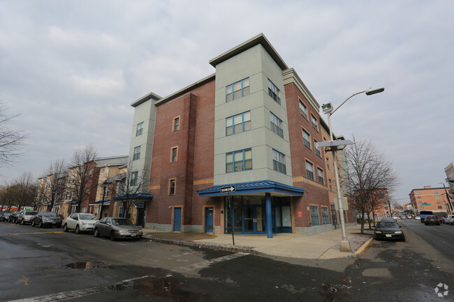

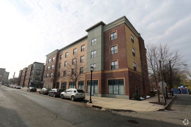
Property Detail
325 Mechanic St
Newark, NJ
88024 SF PILOT PROGRAM
17-02701-0000-00015
ESSEX
Taxexempt
New Jersey
B and X Area of moderate flood hazard, usually the area between the limits of the 100-year and 500-year floods.
15
0
2.02 AC
2025
Lower Essex County
018600
Northern New Jersey
NEARBY LISTINGS FOR SALE OR LEASE
DEMOGRAPHICS near 325 Mechanic St
1 mile
3 mile
5 mile
2025 Total Population
58,451
342,445
813,164
2030 Population
61,660
355,547
844,237
Pop Growth 2025-2030
+ 5.49%
+ 3.83%
+ 3.82%
Average Age
39
38
39
2025 Total Households
22,774
125,868
299,828
HH Growth 2025-2030
+ 5.74%
+ 4.07%
+ 4.10%
Median Household Inc
$62,063
$71,721
$76,666
Avg Household Size
2.50
2.60
2.60
2025 Avg HH Vehicles
1.00
1.00
1.00
Median Home Value
$387,916
$441,794
$472,607
Median Year Built
1961
1955
1957
Nearby Places
Map Layers
Map Styles
 Street
 Aerial
Transit
 Traffic
 Biking
Places
Listings with unknown addresses are not visible on the map
- Restaurants
- Banks
- Shops
- Fitness
- Groceries
PUBLIC TRANSPORTATION
COMMUTER RAIL
Orange (Morris & Essex Gladstone Branch - NJ Transit Commuter Rail (NJ Transit), Morris & Essex Morristown Line - NJ Transit Commuter Rail (NJ Transit))
Drive
Walk
Distance
Orange (Morris & Essex Gladstone Branch - NJ Transit Commuter Rail (NJ Transit), Morris & Essex Morristown Line - NJ Transit Commuter Rail (NJ Transit))
2 min
7 min
0.4 mi
Highland Avenue (Morris & Essex Gladstone Branch - NJ Transit Commuter Rail (NJ Transit), Morris & Essex Morristown Line - NJ Transit Commuter Rail (NJ Transit))
Drive
Walk
Distance
Highland Avenue (Morris & Essex Gladstone Branch - NJ Transit Commuter Rail (NJ Transit), Morris & Essex Morristown Line - NJ Transit Commuter Rail (NJ Transit))
2 min
13 min
0.7 mi
AIRPORT
Newark Liberty International
Drive
Walk
Distance
Newark Liberty International
18 min
9.7 mi
LaGuardia
Drive
Walk
Distance
LaGuardia
48 min
23.7 mi
John F Kennedy International
Drive
Walk
Distance
John F Kennedy International
59 min
33.1 mi
Freight Ports
Maher Terminal
Drive
Walk
Distance
Maher Terminal
23 min
10.8 mi
Nearby Properties
Address
Land Use
TOTAL SIZE
Lot Size
Zoning
Address
Land Use
TOTAL SIZE
Lot Size
Zoning
57.23 AC
U
Address
Land Use
TOTAL SIZE
Lot Size
Zoning
926,120 SF
11.46 AC
Address
Land Use
TOTAL SIZE
Lot Size
Zoning
0.61 AC
Address
Land Use
TOTAL SIZE
Lot Size
Zoning
31.86 AC
Address
Land Use
TOTAL SIZE
Lot Size
Zoning
231 AC
R1-7
Address
Land Use
TOTAL SIZE
Lot Size
Zoning
33.60 AC
P-C
Address
Land Use
TOTAL SIZE
Lot Size
Zoning
Address
Land Use
TOTAL SIZE
Lot Size
Zoning
34.47 AC
R-2
Address
Land Use
TOTAL SIZE
Lot Size
Zoning
0.13 AC
Address
Land Use
TOTAL SIZE
Lot Size
Zoning
16,084 SF
7.23 AC
Address
Land Use
TOTAL SIZE
Lot Size
Zoning
Address
Land Use
TOTAL SIZE
Lot Size
Zoning
3.31 AC
Address
Land Use
TOTAL SIZE
Lot Size
Zoning
0.23 AC
REDV
Address
Land Use
TOTAL SIZE
Lot Size
Zoning
4.60 AC
PRD
Address
Land Use
TOTAL SIZE
Lot Size
Zoning
2.64 AC
Address
Land Use
TOTAL SIZE
Lot Size
Zoning
13.80 AC
R1-5
Address
Land Use
TOTAL SIZE
Lot Size
Zoning
4.92 AC
Address
Land Use
TOTAL SIZE
Lot Size
Zoning
Address
Land Use
TOTAL SIZE
Lot Size
Zoning
4.33 AC
Address
Land Use
TOTAL SIZE
Lot Size
Zoning
11.49 AC
M-1
Address
Land Use
TOTAL SIZE
Lot Size
Zoning
298,272 SF
31.36 AC
P-6
Address
Land Use
TOTAL SIZE
Lot Size
Zoning
7.03 AC
Address
Land Use
TOTAL SIZE
Lot Size
Zoning
306,414 SF
4.62 AC
Address
Land Use
TOTAL SIZE
Lot Size
Zoning
3.26 AC
PR
Address
Land Use
TOTAL SIZE
Lot Size
Zoning
0.17 AC
BCR1
Address
Land Use
TOTAL SIZE
Lot Size
Zoning
2.22 AC
OB-2
Address
Land Use
TOTAL SIZE
Lot Size
Zoning
1.67 AC
BCR1
Address
Land Use
TOTAL SIZE
Lot Size
Zoning
3.28 AC
Address
Land Use
TOTAL SIZE
Lot Size
Zoning
3.20 AC
BSRD
Address
Land Use
TOTAL SIZE
Lot Size
Zoning
224 SF
0.94 AC
BCR1
The World's #1 Commercial Real Estate Marketplace
Connect with us
© 2026 CoStar Group
The information above has been obtained from sources believed reliable. While we do not doubt its accuracy we have not verified it and make no guarantee, warranty or representation about it. It is your responsibility to independently confirm its accuracy and completeness. Any projections, opinions, assumptions, or estimates used are for example only and do not represent the current or future performance of the property. The value of this transaction to you depends on tax and other factors which should be evaluated by your tax, financial, and legal advisors. You and your advisors should conduct a careful, independent investigation of the property to determine to your satisfaction the suitability of the property for your needs.