Property Record
866 W Peachtree St Nw, Atlanta, GA 30308


Save to a Folder
{{folder.Name}}
{{folder.ListingIds.length}} Properties
{{folder.ListingIds.length}} Property
Create a New Folder
Property Detail
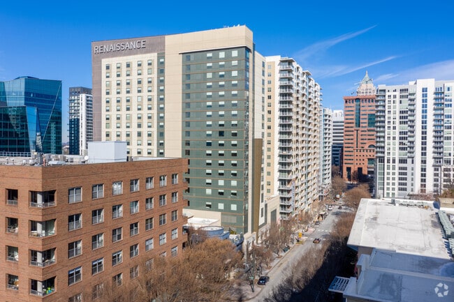
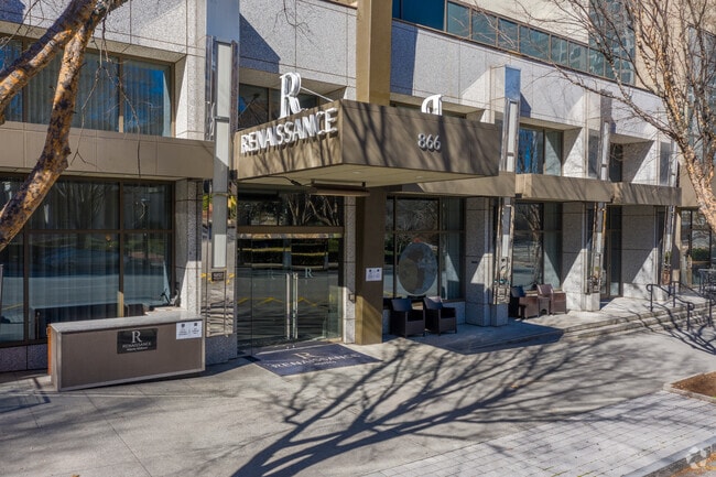
866 W Peachtree St Nw
14-0080-0003-203-1
RENAISSANCE MIDTOWN HOTEL
Hotel
Fulton
C4
Georgia
B and X Area of moderate flood hazard, usually the area between the limits of the 100-year and 500-year floods.
80
2025
0.90 AC
2025
Atlanta CBD
001001
Atlanta
244,504 SF
Atlanta-Sandy Springs-Roswell, GA
NEARBY LISTINGS FOR SALE OR LEASE
DEMOGRAPHICS near 866 W Peachtree St Nw
1 mile
3 mile
5 mile
2025 Total Population
47,676
209,019
427,029
2030 Population
49,020
216,925
443,585
Pop Growth 2025-2030
+ 2.82%
+ 3.78%
+ 3.88%
Average Age
35
36
37
2025 Total Households
24,958
103,423
202,038
HH Growth 2025-2030
+ 3.18%
+ 4.06%
+ 4.02%
Median Household Inc
$110,162
$102,253
$99,282
Avg Household Size
1.50
1.70
1.90
2025 Avg HH Vehicles
1.00
1.00
1.00
Median Home Value
$437,489
$620,036
$587,548
Median Year Built
2002
2000
1993
Nearby Places
Map Layers
Map Styles
 Street
 Aerial
Layers
 Traffic
 Biking
Places
Listings with unknown addresses are not visible on the map
- Restaurants
- Banks
- Shops
- Fitness
- Groceries
PUBLIC TRANSPORTATION
TRANSIT/SUBWAY
Midtown (Gold Line - Metropolitan Atlanta Rapid Transit Authority (MARTA), Red Line - Metropolitan Atlanta Rapid Transit Authority (MARTA))
Drive
Walk
Distance
Midtown (Gold Line - Metropolitan Atlanta Rapid Transit Authority (MARTA), Red Line - Metropolitan Atlanta Rapid Transit Authority (MARTA))
1 min
6 min
0.4 mi
North Avenue (Gold Line - Metropolitan Atlanta Rapid Transit Authority (MARTA), Red Line - Metropolitan Atlanta Rapid Transit Authority (MARTA))
Drive
Walk
Distance
North Avenue (Gold Line - Metropolitan Atlanta Rapid Transit Authority (MARTA), Red Line - Metropolitan Atlanta Rapid Transit Authority (MARTA))
2 min
10 min
0.6 mi
Arts Center (Gold Line - Metropolitan Atlanta Rapid Transit Authority (MARTA), Red Line - Metropolitan Atlanta Rapid Transit Authority (MARTA))
Drive
Walk
Distance
Arts Center (Gold Line - Metropolitan Atlanta Rapid Transit Authority (MARTA), Red Line - Metropolitan Atlanta Rapid Transit Authority (MARTA))
2 min
17 min
0.8 mi
Civic Center (Gold Line - Metropolitan Atlanta Rapid Transit Authority (MARTA), Red Line - Metropolitan Atlanta Rapid Transit Authority (MARTA))
Drive
Walk
Distance
Civic Center (Gold Line - Metropolitan Atlanta Rapid Transit Authority (MARTA), Red Line - Metropolitan Atlanta Rapid Transit Authority (MARTA))
2 min
16 min
0.9 mi
COMMUTER RAIL
Atlanta (Crescent - Amtrak)
Drive
Walk
Distance
Atlanta (Crescent - Amtrak)
4 min
1.8 mi
AIRPORT
Hartsfield - Jackson Atlanta International
Drive
Walk
Distance
Hartsfield - Jackson Atlanta International
19 min
11.8 mi
Freight Ports
Georgia Ports - Savannah
Drive
Walk
Distance
Georgia Ports - Savannah
282 min
251.1 mi
Nearby Properties
Address
Land Use
TOTAL SIZE
Lot Size
Zoning
Address
Land Use
TOTAL SIZE
Lot Size
Zoning
19.94 AC
SPI1
Address
Land Use
TOTAL SIZE
Lot Size
Zoning
1,585,451 SF
1.97 AC
SPI2
Address
Land Use
TOTAL SIZE
Lot Size
Zoning
2,283,599 SF
12.93 AC
I1
Address
Land Use
TOTAL SIZE
Lot Size
Zoning
9.80 AC
C5
Address
Land Use
TOTAL SIZE
Lot Size
Zoning
179.40 AC
R4
Address
Land Use
TOTAL SIZE
Lot Size
Zoning
3.16 AC
SPI1
Address
Land Use
TOTAL SIZE
Lot Size
Zoning
9 AC
C5
Address
Land Use
TOTAL SIZE
Lot Size
Zoning
10.27 AC
C5
Address
Land Use
TOTAL SIZE
Lot Size
Zoning
1,039,831 SF
0.31 AC
C4
Address
Land Use
TOTAL SIZE
Lot Size
Zoning
1,227,912 SF
2.15 AC
SPI4
Address
Land Use
TOTAL SIZE
Lot Size
Zoning
1,736,017 SF
3.63 AC
SPI2
Address
Land Use
TOTAL SIZE
Lot Size
Zoning
2,044,200 SF
9.16 AC
C3
Address
Land Use
TOTAL SIZE
Lot Size
Zoning
1,300,309 SF
4.81 AC
SPI1
Address
Land Use
TOTAL SIZE
Lot Size
Zoning
1,434,872 SF
1.89 AC
SPI1
Address
Land Use
TOTAL SIZE
Lot Size
Zoning
61.57 AC
C5
Address
Land Use
TOTAL SIZE
Lot Size
Zoning
1,116,157 SF
1.48 AC
SPI3
Address
Land Use
TOTAL SIZE
Lot Size
Zoning
1,467,469 SF
0.07 AC
C4
Address
Land Use
TOTAL SIZE
Lot Size
Zoning
903,671 SF
1 AC
C3
Address
Land Use
TOTAL SIZE
Lot Size
Zoning
10,954,869 SF
28.88 AC
C3
Address
Land Use
TOTAL SIZE
Lot Size
Zoning
1.55 AC
SPI1
Address
Land Use
TOTAL SIZE
Lot Size
Zoning
1,646,011 SF
3.74 AC
SPI4
Address
Land Use
TOTAL SIZE
Lot Size
Zoning
7 AC
C3
Address
Land Use
TOTAL SIZE
Lot Size
Zoning
342,275 SF
0.70 AC
SPI3
Address
Land Use
TOTAL SIZE
Lot Size
Zoning
903,732 SF
0.34 AC
SPI1
Address
Land Use
TOTAL SIZE
Lot Size
Zoning
467,847 SF
1.62 AC
I2
Address
Land Use
TOTAL SIZE
Lot Size
Zoning
1,314,183 SF
2.61 AC
SPI1
Address
Land Use
TOTAL SIZE
Lot Size
Zoning
2,577,342 SF
2.04 AC
SPI1
Address
Land Use
TOTAL SIZE
Lot Size
Zoning
1,356,182 SF
2.52 AC
SPI4
Address
Land Use
TOTAL SIZE
Lot Size
Zoning
1,121,700 SF
2.21 AC
I2
Address
Land Use
TOTAL SIZE
Lot Size
Zoning
13,340,229 SF
3.68 AC
SPI1
The World's #1 Commercial Real Estate Marketplace
Connect with us
© 2026 CoStar Group
The information above has been obtained from sources believed reliable. While we do not doubt its accuracy we have not verified it and make no guarantee, warranty or representation about it. It is your responsibility to independently confirm its accuracy and completeness. Any projections, opinions, assumptions, or estimates used are for example only and do not represent the current or future performance of the property. The value of this transaction to you depends on tax and other factors which should be evaluated by your tax, financial, and legal advisors. You and your advisors should conduct a careful, independent investigation of the property to determine to your satisfaction the suitability of the property for your needs.