Property Record
6110 Belmont Rd, Chesterfield, VA 23832
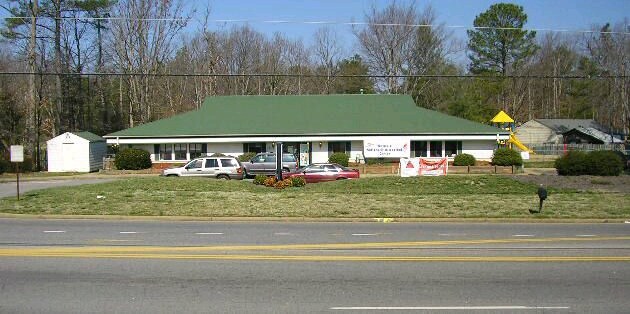

Property Detail
6110 Belmont Rd
769-69-06-25-900-000
BELMONT FARMS L 2 (PARCEL A)
Daycare
Chesterfield
A - AGRICU
Virginia
B and X Area of moderate flood hazard, usually the area between the limits of the 100-year and 500-year floods.
2
2026
1.01 AC
2026
Midlothian E/Hull St
100206
Richmond VA
4,950 SF
Richmond, VA
NEARBY LISTINGS FOR SALE OR LEASE
-
-
View all Chesterfield listings for sale on LoopNet.com
DEMOGRAPHICS near 6110 Belmont Rd
1 mile
3 mile
5 mile
2025 Total Population
12,298
73,996
179,269
2030 Population
12,899
77,573
187,766
Pop Growth 2025-2030
+ 4.89%
+ 4.83%
+ 4.74%
Average Age
37
39
39
2025 Total Households
4,518
27,230
68,756
HH Growth 2025-2030
+ 5.09%
+ 4.95%
+ 4.81%
Median Household Inc
$65,737
$76,564
$71,261
Avg Household Size
2.60
2.70
2.50
2025 Avg HH Vehicles
2.00
2.00
2.00
Median Home Value
$268,675
$291,017
$295,938
Median Year Built
1985
1982
1980
Nearby Places
Map Layers
Map Styles
 Street
 Aerial
Layers
 Traffic
 Biking
Places
Listings with unknown addresses are not visible on the map
- Restaurants
- Banks
- Shops
- Fitness
- Groceries
PUBLIC TRANSPORTATION
COMMUTER RAIL
Richmond Main Street Amtrak Station (Northeast Regional - Amtrak)
Drive
Walk
Distance
Richmond Main Street Amtrak Station (Northeast Regional - Amtrak)
17 min
8.0 mi
AIRPORT
Richmond International
Drive
Walk
Distance
Richmond International
25 min
16.6 mi
Freight Ports
Virginia Port Authority - Richmond
Drive
Walk
Distance
Virginia Port Authority - Richmond
15 min
7.0 mi
Nearby Properties
Address
Land Use
TOTAL SIZE
Lot Size
Zoning
Address
Land Use
TOTAL SIZE
Lot Size
Zoning
73,867 SF
54.52 AC
R7 - SINGL
Address
Land Use
TOTAL SIZE
Lot Size
Zoning
387,548 SF
16.18 AC
C3 - COMMU
Address
Land Use
TOTAL SIZE
Lot Size
Zoning
117,516 SF
21.23 AC
R7 - SINGL
Address
Land Use
TOTAL SIZE
Lot Size
Zoning
3,713 SF
24.57 AC
R-43 MULTI
Address
Land Use
TOTAL SIZE
Lot Size
Zoning
12.42 AC
RTH - RES,
Address
Land Use
TOTAL SIZE
Lot Size
Zoning
83,186 SF
25.90 AC
O2 - CORP
Address
Land Use
TOTAL SIZE
Lot Size
Zoning
290,200 SF
50.99 AC
R7 - SINGL
Address
Land Use
TOTAL SIZE
Lot Size
Zoning
100 SF
22.70 AC
R7 - SINGL
Address
Land Use
TOTAL SIZE
Lot Size
Zoning
183,759 SF
19.59 AC
R-3 SINGLE
Address
Land Use
TOTAL SIZE
Lot Size
Zoning
7,630 SF
63.16 AC
A - AGRICU
Address
Land Use
TOTAL SIZE
Lot Size
Zoning
100 SF
12.96 AC
R7 - SINGL
Address
Land Use
TOTAL SIZE
Lot Size
Zoning
100 SF
18.04 AC
R7 - SINGL
Address
Land Use
TOTAL SIZE
Lot Size
Zoning
117,740 SF
9.95 AC
R-48 MULTI
Address
Land Use
TOTAL SIZE
Lot Size
Zoning
132,570 SF
12.60 AC
R-48 MULTI
Address
Land Use
TOTAL SIZE
Lot Size
Zoning
100 SF
10.85 AC
R7 - SINGL
Address
Land Use
TOTAL SIZE
Lot Size
Zoning
6.90 AC
R7 - SINGL
Address
Land Use
TOTAL SIZE
Lot Size
Zoning
69,010 SF
15.77 AC
R9 - SINGL
Address
Land Use
TOTAL SIZE
Lot Size
Zoning
57,785 SF
30.27 AC
A - AGRICU
Address
Land Use
TOTAL SIZE
Lot Size
Zoning
134,400 SF
11.76 AC
R-48 MULTI
Address
Land Use
TOTAL SIZE
Lot Size
Zoning
213,003 SF
16.48 AC
B-3 GENERA
Address
Land Use
TOTAL SIZE
Lot Size
Zoning
100 SF
8.02 AC
R7 - SINGL
Address
Land Use
TOTAL SIZE
Lot Size
Zoning
149,520 SF
14.69 AC
MULTIPLE Z
Address
Land Use
TOTAL SIZE
Lot Size
Zoning
47,011 SF
8.23 AC
O2 - CORP
Address
Land Use
TOTAL SIZE
Lot Size
Zoning
5,412 SF
18.62 AC
C3 - COMMU
Address
Land Use
TOTAL SIZE
Lot Size
Zoning
56,148 SF
6.97 AC
R7 - SINGL
Address
Land Use
TOTAL SIZE
Lot Size
Zoning
100 SF
18.40 AC
RMF - RES,
Address
Land Use
TOTAL SIZE
Lot Size
Zoning
87,876 SF
6.48 AC
MULTIPLE Z
Address
Land Use
TOTAL SIZE
Lot Size
Zoning
100 SF
12.93 AC
RMF - RES,
Address
Land Use
TOTAL SIZE
Lot Size
Zoning
260,048 SF
6.26 AC
MULTIPLE Z
Address
Land Use
TOTAL SIZE
Lot Size
Zoning
100 SF
7.70 AC
R7 - SINGL
The World's #1 Commercial Real Estate Marketplace
Connect with us
© 2026 CoStar Group
The information above has been obtained from sources believed reliable. While we do not doubt its accuracy we have not verified it and make no guarantee, warranty or representation about it. It is your responsibility to independently confirm its accuracy and completeness. Any projections, opinions, assumptions, or estimates used are for example only and do not represent the current or future performance of the property. The value of this transaction to you depends on tax and other factors which should be evaluated by your tax, financial, and legal advisors. You and your advisors should conduct a careful, independent investigation of the property to determine to your satisfaction the suitability of the property for your needs.