Property Record
619 N 9Th St, Lafayette, IN 47904
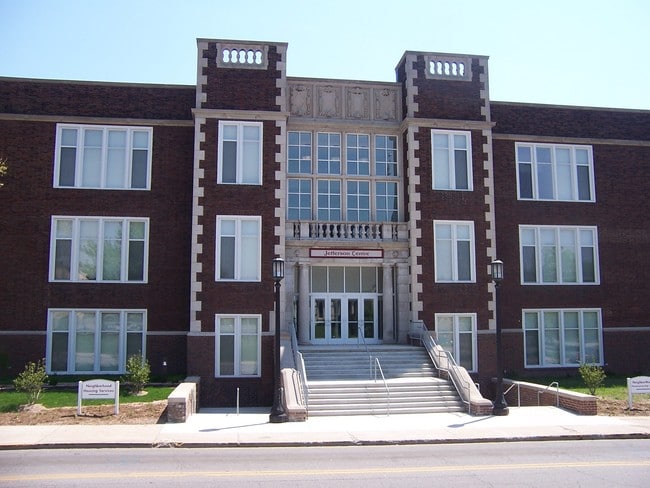

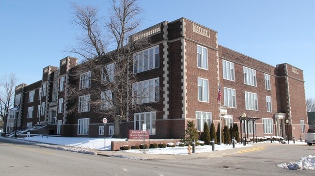
Property Detail
619 N 9Th St
79-07-21-303-002.000-004
HISTORIC JEFF CENTRE PD LOT 1
Apartment
Tippecanoe
PDMX
Indiana
B and X Area of moderate flood hazard, usually the area between the limits of the 100-year and 500-year floods.
1
2024
1.89 AC
2025
Downtown Lafayette
000400
Other Market Areas
103,852 SF
Lafayette-West Lafayette, IN
NEARBY LISTINGS FOR SALE OR LEASE
DEMOGRAPHICS near 619 N 9Th St
1 mile
3 mile
5 mile
2025 Total Population
15,764
95,541
155,730
2030 Population
16,103
99,492
160,901
Pop Growth 2025-2030
+ 2.15%
+ 4.14%
+ 3.32%
Average Age
35
34
35
2025 Total Households
7,388
37,438
62,127
HH Growth 2025-2030
+ 2.29%
+ 4.65%
+ 3.65%
Median Household Inc
$41,748
$46,698
$56,682
Avg Household Size
2.00
2.10
2.20
2025 Avg HH Vehicles
1.00
2.00
2.00
Median Home Value
$167,650
$220,580
$247,784
Median Year Built
1953
1977
1989
Nearby Places
Map Layers
Map Styles
 Street
 Aerial
Layers
 Traffic
 Biking
Places
Listings with unknown addresses are not visible on the map
- Restaurants
- Banks
- Shops
- Fitness
- Groceries
PUBLIC TRANSPORTATION
COMMUTER RAIL
Lafayette Amtrak Station (Cardinal - Amtrak)
Drive
Walk
Distance
Lafayette Amtrak Station (Cardinal - Amtrak)
2 min
14 min
0.8 mi
Freight Ports
Port Milwaukee
Drive
Walk
Distance
Port Milwaukee
249 min
207.1 mi
SALE & LEASE HISTORY
LISTING DATE
SALE/LEASE

Sep 25, 2016
For Lease
Nearby Properties
Address
Land Use
TOTAL SIZE
Lot Size
Zoning
Address
Land Use
TOTAL SIZE
Lot Size
Zoning
469,872 SF
0.85 AC
Address
Land Use
TOTAL SIZE
Lot Size
Zoning
377,937 SF
4.80 AC
Address
Land Use
TOTAL SIZE
Lot Size
Zoning
403,394 SF
1.64 AC
PDMX
Address
Land Use
TOTAL SIZE
Lot Size
Zoning
357,185 SF
1 AC
PDMX
Address
Land Use
TOTAL SIZE
Lot Size
Zoning
498,665 SF
1.94 AC
Address
Land Use
TOTAL SIZE
Lot Size
Zoning
Address
Land Use
TOTAL SIZE
Lot Size
Zoning
417,720 SF
3.09 AC
Address
Land Use
TOTAL SIZE
Lot Size
Zoning
Address
Land Use
TOTAL SIZE
Lot Size
Zoning
249,214 SF
1.93 AC
PDMX
Address
Land Use
TOTAL SIZE
Lot Size
Zoning
3.89 AC
Address
Land Use
TOTAL SIZE
Lot Size
Zoning
402,757 SF
23.10 AC
Address
Land Use
TOTAL SIZE
Lot Size
Zoning
245,798 SF
1.15 AC
Address
Land Use
TOTAL SIZE
Lot Size
Zoning
159,723 SF
4.87 AC
Address
Land Use
TOTAL SIZE
Lot Size
Zoning
148,860 SF
1.25 AC
Address
Land Use
TOTAL SIZE
Lot Size
Zoning
210,829 SF
87 SF
Address
Land Use
TOTAL SIZE
Lot Size
Zoning
0.01 AC
Address
Land Use
TOTAL SIZE
Lot Size
Zoning
10,864 SF
51.87 AC
PDMX
Address
Land Use
TOTAL SIZE
Lot Size
Zoning
232,565 SF
1.15 AC
Address
Land Use
TOTAL SIZE
Lot Size
Zoning
1,449,360 SF
0.01 AC
Address
Land Use
TOTAL SIZE
Lot Size
Zoning
205,701 SF
1.27 AC
Address
Land Use
TOTAL SIZE
Lot Size
Zoning
221,751 SF
1.16 AC
Address
Land Use
TOTAL SIZE
Lot Size
Zoning
77,226 SF
0.01 AC
Address
Land Use
TOTAL SIZE
Lot Size
Zoning
184,441 SF
5.57 AC
PDNR
Address
Land Use
TOTAL SIZE
Lot Size
Zoning
164,234 SF
0.88 AC
CB
Address
Land Use
TOTAL SIZE
Lot Size
Zoning
27,300 SF
22.52 AC
Address
Land Use
TOTAL SIZE
Lot Size
Zoning
222,276 SF
0.31 AC
Address
Land Use
TOTAL SIZE
Lot Size
Zoning
203,830 SF
18.73 AC
Address
Land Use
TOTAL SIZE
Lot Size
Zoning
518,808 SF
174 SF
Address
Land Use
TOTAL SIZE
Lot Size
Zoning
141,960 SF
2.27 AC
The World's #1 Commercial Real Estate Marketplace
Connect with us
© 2026 CoStar Group
The information above has been obtained from sources believed reliable. While we do not doubt its accuracy we have not verified it and make no guarantee, warranty or representation about it. It is your responsibility to independently confirm its accuracy and completeness. Any projections, opinions, assumptions, or estimates used are for example only and do not represent the current or future performance of the property. The value of this transaction to you depends on tax and other factors which should be evaluated by your tax, financial, and legal advisors. You and your advisors should conduct a careful, independent investigation of the property to determine to your satisfaction the suitability of the property for your needs.