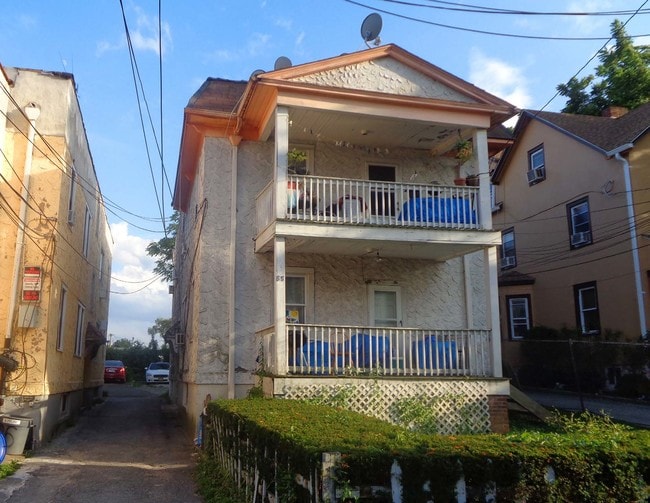
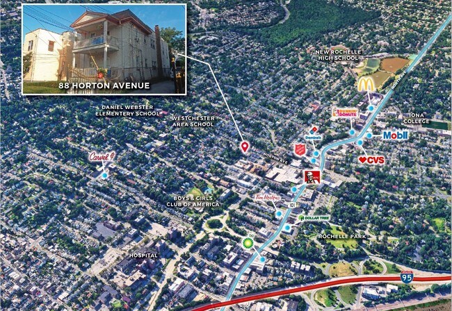
Property Record
88 Horton Ave, New Rochelle, NY 10801

Property Detail
88 Horton Ave
New York-Jersey City-White Plains, NY-NJ
Westchester
1000-000-005-01413-000-0056
New York
Apartment
0.056
B and X Area of moderate flood hazard, usually the area between the limits of the 100-year and 500-year floods.
0.09 AC
2025
Downtown New Rochelle
2025
Westchester/So Connecticut
006400
NEARBY LISTINGS FOR SALE OR LEASE
DEMOGRAPHICS near 88 Horton Ave
1 mile
3 mile
5 mile
2025 Total Population
44,197
207,759
524,151
2030 Population
44,778
208,714
514,271
Pop Growth 2025-2030
+ 1.31%
+ 0.46%
(1.88%)
Average Age
39
41
42
2025 Total Households
15,240
77,909
195,439
HH Growth 2025-2030
+ 1.63%
+ 0.63%
(1.86%)
Median Household Inc
$97,730
$103,003
$90,765
Avg Household Size
2.70
2.50
2.60
2025 Avg HH Vehicles
1.00
1.00
1.00
Median Home Value
$673,297
$684,142
$631,967
Median Year Built
1948
1949
1953
Nearby Places
Map Layers
Map Styles
 Street
 Aerial
Layers
 Traffic
 Biking
Places
Listings with unknown addresses are not visible on the map
- Restaurants
- Banks
- Shops
- Fitness
- Groceries
PUBLIC TRANSPORTATION
COMMUTER RAIL
New Rochelle Station (New Haven Line - Metro-North Commuter Railroad Company (Metro-North))
Drive
Walk
Distance
New Rochelle Station (New Haven Line - Metro-North Commuter Railroad Company (Metro-North))
2 min
16 min
0.9 mi
Pelham Station (New Haven Line - Metro-North Commuter Railroad Company (Metro-North))
Drive
Walk
Distance
Pelham Station (New Haven Line - Metro-North Commuter Railroad Company (Metro-North))
4 min
1.8 mi
AIRPORT
Westchester County
Drive
Walk
Distance
Westchester County
24 min
15.4 mi
LaGuardia
Drive
Walk
Distance
LaGuardia
27 min
15.5 mi
John F Kennedy International
Drive
Walk
Distance
John F Kennedy International
33 min
23.0 mi
Freight Ports
NY - Red Hook Container Terminal
Drive
Walk
Distance
NY - Red Hook Container Terminal
42 min
26.0 mi
SALE & LEASE HISTORY
LISTING DATE
SALE/LEASE

Sep 12, 2019
For Sale
Nearby Properties
Address
Land Use
TOTAL SIZE
Lot Size
Zoning
Address
Land Use
TOTAL SIZE
Lot Size
Zoning
18,000 SF
13.85 AC
A
Address
Land Use
TOTAL SIZE
Lot Size
Zoning
201,590 SF
4.13 AC
BA
Address
Land Use
TOTAL SIZE
Lot Size
Zoning
301,156 SF
13.94 AC
A
Address
Land Use
TOTAL SIZE
Lot Size
Zoning
413,946 SF
20.27 AC
Address
Land Use
TOTAL SIZE
Lot Size
Zoning
Address
Land Use
TOTAL SIZE
Lot Size
Zoning
4,000 SF
19.83 AC
BUS
Address
Land Use
TOTAL SIZE
Lot Size
Zoning
70,737 SF
1.67 AC
BB
Address
Land Use
TOTAL SIZE
Lot Size
Zoning
Address
Land Use
TOTAL SIZE
Lot Size
Zoning
Address
Land Use
TOTAL SIZE
Lot Size
Zoning
Address
Land Use
TOTAL SIZE
Lot Size
Zoning
64,165 SF
3.24 AC
B
Address
Land Use
TOTAL SIZE
Lot Size
Zoning
165,529 SF
7.05 AC
RA3
Address
Land Use
TOTAL SIZE
Lot Size
Zoning
118,723 SF
3.45 AC
Address
Land Use
TOTAL SIZE
Lot Size
Zoning
5,170 SF
9.08 AC
B
Address
Land Use
TOTAL SIZE
Lot Size
Zoning
132,505 SF
5.53 AC
R6
Address
Land Use
TOTAL SIZE
Lot Size
Zoning
Address
Land Use
TOTAL SIZE
Lot Size
Zoning
99,502 SF
11.97 AC
Address
Land Use
TOTAL SIZE
Lot Size
Zoning
74,147 SF
2.76 AC
Address
Land Use
TOTAL SIZE
Lot Size
Zoning
48,240 SF
3.89 AC
Address
Land Use
TOTAL SIZE
Lot Size
Zoning
Address
Land Use
TOTAL SIZE
Lot Size
Zoning
76,258 SF
4.22 AC
R7.5
Address
Land Use
TOTAL SIZE
Lot Size
Zoning
92,960 SF
11.39 AC
Address
Land Use
TOTAL SIZE
Lot Size
Zoning
7,855 SF
1.10 AC
C
Address
Land Use
TOTAL SIZE
Lot Size
Zoning
62,664 SF
3.50 AC
Address
Land Use
TOTAL SIZE
Lot Size
Zoning
52,138 SF
3.24 AC
R6
Address
Land Use
TOTAL SIZE
Lot Size
Zoning
24,668 SF
11.17 AC
Address
Land Use
TOTAL SIZE
Lot Size
Zoning
Address
Land Use
TOTAL SIZE
Lot Size
Zoning
91,463 SF
0.69 AC
Address
Land Use
TOTAL SIZE
Lot Size
Zoning
42,053 SF
4.11 AC
MUL
Address
Land Use
TOTAL SIZE
Lot Size
Zoning
38,080 SF
3.62 AC
The World's #1 Commercial Real Estate Marketplace
Connect with us
© 2026 CoStar Group
The information above has been obtained from sources believed reliable. While we do not doubt its accuracy we have not verified it and make no guarantee, warranty or representation about it. It is your responsibility to independently confirm its accuracy and completeness. Any projections, opinions, assumptions, or estimates used are for example only and do not represent the current or future performance of the property. The value of this transaction to you depends on tax and other factors which should be evaluated by your tax, financial, and legal advisors. You and your advisors should conduct a careful, independent investigation of the property to determine to your satisfaction the suitability of the property for your needs.