Property Record
7001 Development Dr, Morrisville, NC 27560

Property Detail
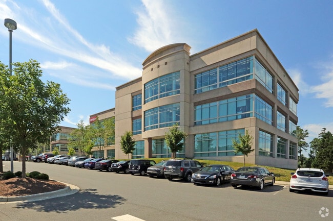
7001 Development Dr
0736.02-79-0977-000
LO14 RESEARCH TRIANGLE PARK BM1994-01745
Officebuilding
WAKE
RA
North Carolina
AE The base floodplain where base flood elevations are provided. AE Zones are now used on new format FIRMs instead of A1-A30 Zones.
14
2025
25.48 AC
2025
RTP/RDU
053619
Raleigh/Durham
233,513 SF
Raleigh-Cary, NC
NEARBY LISTINGS FOR SALE OR LEASE
DEMOGRAPHICS near 7001 Development Dr
1 mile
3 mile
5 mile
2025 Total Population
1,101
51,205
142,417
2030 Population
1,170
55,454
153,025
Pop Growth 2025-2030
+ 6.27%
+ 8.30%
+ 7.45%
Average Age
34
36
38
2025 Total Households
338
20,044
56,945
HH Growth 2025-2030
+ 6.51%
+ 8.62%
+ 7.70%
Median Household Inc
$179,032
$126,321
$127,053
Avg Household Size
3.30
2.50
2.50
2025 Avg HH Vehicles
2.00
2.00
2.00
Median Home Value
$605,714
$569,316
$599,605
Median Year Built
2010
2010
2007
Nearby Places
Map Layers
Map Styles
 Street
 Aerial
Transit
 Traffic
 Biking
Places
Listings with unknown addresses are not visible on the map
- Restaurants
- Banks
- Shops
- Fitness
- Groceries
PUBLIC TRANSPORTATION
COMMUTER RAIL
Cary Station (Piedmont - North Carolina by Train (NC Train))
Drive
Walk
Distance
Cary Station (Piedmont - North Carolina by Train (NC Train))
18 min
9.3 mi
AIRPORT
Raleigh-Durham International
Drive
Walk
Distance
Raleigh-Durham International
15 min
7.5 mi
Nearby Properties
Address
Land Use
TOTAL SIZE
Lot Size
Zoning
Address
Land Use
TOTAL SIZE
Lot Size
Zoning
896,802 SF
86.14 AC
RA
Address
Land Use
TOTAL SIZE
Lot Size
Zoning
1,272,163 SF
117.61 AC
OI,SRP
Address
Land Use
TOTAL SIZE
Lot Size
Zoning
1,378,965 SF
183.46 AC
SRP
Address
Land Use
TOTAL SIZE
Lot Size
Zoning
868,283 SF
56.23 AC
SRP
Address
Land Use
TOTAL SIZE
Lot Size
Zoning
480,202 SF
34.36 AC
RMFM
Address
Land Use
TOTAL SIZE
Lot Size
Zoning
507,119 SF
118.85 AC
SRP
Address
Land Use
TOTAL SIZE
Lot Size
Zoning
168,660 SF
15.49 AC
CG(D)
Address
Land Use
TOTAL SIZE
Lot Size
Zoning
444,254 SF
58.71 AC
SRP
Address
Land Use
TOTAL SIZE
Lot Size
Zoning
8,418 SF
22.17 AC
MU(D)
Address
Land Use
TOTAL SIZE
Lot Size
Zoning
122,544 SF
8.04 AC
MU(D)
Address
Land Use
TOTAL SIZE
Lot Size
Zoning
624,324 SF
81.65 AC
RA
Address
Land Use
TOTAL SIZE
Lot Size
Zoning
627,566 SF
37.83 AC
RA
Address
Land Use
TOTAL SIZE
Lot Size
Zoning
449,992 SF
25.16 AC
IP
Address
Land Use
TOTAL SIZE
Lot Size
Zoning
597,624 SF
53.04 AC
RA
Address
Land Use
TOTAL SIZE
Lot Size
Zoning
373,099 SF
14.08 AC
GCM
Address
Land Use
TOTAL SIZE
Lot Size
Zoning
355,402 SF
24.19 AC
RMFP
Address
Land Use
TOTAL SIZE
Lot Size
Zoning
47,376 SF
11.86 AC
OI(D)
Address
Land Use
TOTAL SIZE
Lot Size
Zoning
319,275 SF
50.52 AC
SRP
Address
Land Use
TOTAL SIZE
Lot Size
Zoning
326,853 SF
12.96 AC
TRM
Address
Land Use
TOTAL SIZE
Lot Size
Zoning
353,339 SF
25.95 AC
SRP
Address
Land Use
TOTAL SIZE
Lot Size
Zoning
477,384 SF
37.07 AC
RMFM
Address
Land Use
TOTAL SIZE
Lot Size
Zoning
287,321 SF
12.68 AC
GCM
Address
Land Use
TOTAL SIZE
Lot Size
Zoning
2.82 AC
SRP-C
Address
Land Use
TOTAL SIZE
Lot Size
Zoning
292,739 SF
55.64 AC
GCM
Address
Land Use
TOTAL SIZE
Lot Size
Zoning
266,419 SF
77.78 AC
RA
Address
Land Use
TOTAL SIZE
Lot Size
Zoning
529,439 SF
29.84 AC
IL
Address
Land Use
TOTAL SIZE
Lot Size
Zoning
172,116 SF
56.06 AC
C-OI
Address
Land Use
TOTAL SIZE
Lot Size
Zoning
298,457 SF
35.55 AC
RAC
Address
Land Use
TOTAL SIZE
Lot Size
Zoning
300,042 SF
41.03 AC
SRP
Address
Land Use
TOTAL SIZE
Lot Size
Zoning
251,738 SF
9.74 AC
GCM
The World's #1 Commercial Real Estate Marketplace
Connect with us
© 2026 CoStar Group
The information above has been obtained from sources believed reliable. While we do not doubt its accuracy we have not verified it and make no guarantee, warranty or representation about it. It is your responsibility to independently confirm its accuracy and completeness. Any projections, opinions, assumptions, or estimates used are for example only and do not represent the current or future performance of the property. The value of this transaction to you depends on tax and other factors which should be evaluated by your tax, financial, and legal advisors. You and your advisors should conduct a careful, independent investigation of the property to determine to your satisfaction the suitability of the property for your needs.