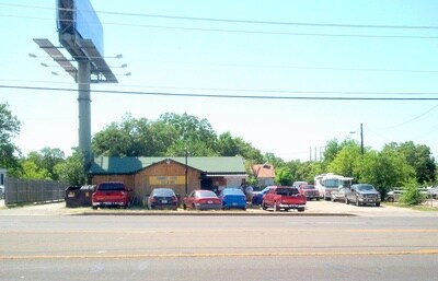
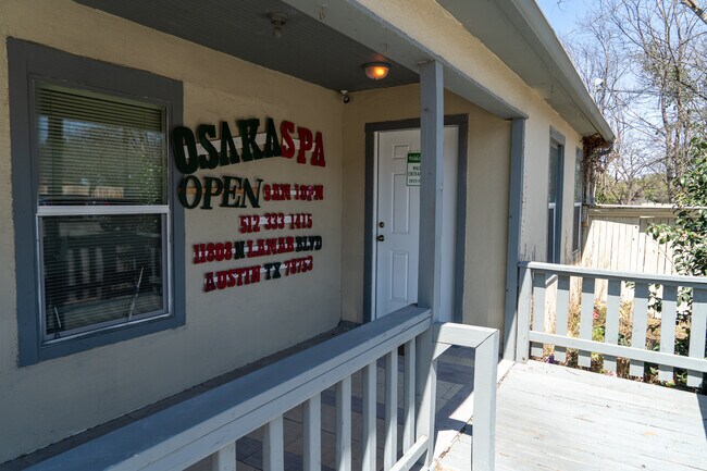
Property Record
11808 N Lamar Blvd, Austin, TX 78753


Property Detail
11808 N Lamar Blvd
Austin-Round Rock-San Marcos, TX
.568 AC OF LOT 4 STARK FRANK SUBD
503135
Travis
Bartavern
Texas
B and X Area of moderate flood hazard, usually the area between the limits of the 100-year and 500-year floods.
4
2025
0.57 AC
2025
North/Domain
041900
Austin
2,484 SF
NEARBY LISTINGS FOR SALE OR LEASE
DEMOGRAPHICS near 11808 N Lamar Blvd
1 mile
3 mile
5 mile
2025 Total Population
11,797
144,330
325,038
2030 Population
12,341
150,921
340,267
Pop Growth 2025-2030
+ 4.61%
+ 4.57%
+ 4.69%
Average Age
39
36
37
2025 Total Households
4,921
60,503
139,690
HH Growth 2025-2030
+ 5.24%
+ 5.18%
+ 5.32%
Median Household Inc
$92,253
$75,379
$80,374
Avg Household Size
2.40
2.30
2.30
2025 Avg HH Vehicles
2.00
2.00
2.00
Median Home Value
$485,751
$429,201
$473,276
Median Year Built
1987
1995
1994
Nearby Places
Map Layers
Map Styles
 Street
 Aerial
Layers
 Traffic
 Biking
Places
Listings with unknown addresses are not visible on the map
- Restaurants
- Banks
- Shops
- Fitness
- Groceries
PUBLIC TRANSPORTATION
AIRPORT
Austin-Bergstrom International
Drive
Walk
Distance
Austin-Bergstrom International
32 min
20.2 mi
Freight Ports
Calhoun Port
Drive
Walk
Distance
Calhoun Port
197 min
163.7 mi
SALE & LEASE HISTORY
LISTING DATE
SALE/LEASE

Feb 28, 2022
For Sale
Nearby Properties
Address
Land Use
TOTAL SIZE
Lot Size
Zoning
Address
Land Use
TOTAL SIZE
Lot Size
Zoning
230.30 AC
Address
Land Use
TOTAL SIZE
Lot Size
Zoning
702,590 SF
48.64 AC
Address
Land Use
TOTAL SIZE
Lot Size
Zoning
1,145,461 SF
34.05 AC
Address
Land Use
TOTAL SIZE
Lot Size
Zoning
371,269 SF
27.63 AC
Address
Land Use
TOTAL SIZE
Lot Size
Zoning
326,626 SF
2.54 AC
Address
Land Use
TOTAL SIZE
Lot Size
Zoning
750,565 SF
65.25 AC
Address
Land Use
TOTAL SIZE
Lot Size
Zoning
666,331 SF
36.37 AC
Address
Land Use
TOTAL SIZE
Lot Size
Zoning
320,104 SF
3.27 AC
Address
Land Use
TOTAL SIZE
Lot Size
Zoning
295,320 SF
2.99 AC
Address
Land Use
TOTAL SIZE
Lot Size
Zoning
323,406 SF
2.36 AC
Address
Land Use
TOTAL SIZE
Lot Size
Zoning
571,738 SF
36.06 AC
Address
Land Use
TOTAL SIZE
Lot Size
Zoning
456,682 SF
7.34 AC
Address
Land Use
TOTAL SIZE
Lot Size
Zoning
293,224 SF
4.45 AC
Address
Land Use
TOTAL SIZE
Lot Size
Zoning
316,888 SF
3.79 AC
Address
Land Use
TOTAL SIZE
Lot Size
Zoning
368,100 SF
38.07 AC
Address
Land Use
TOTAL SIZE
Lot Size
Zoning
352,386 SF
33.65 AC
Address
Land Use
TOTAL SIZE
Lot Size
Zoning
340,785 SF
1.89 AC
Address
Land Use
TOTAL SIZE
Lot Size
Zoning
340,000 SF
1.54 AC
Address
Land Use
TOTAL SIZE
Lot Size
Zoning
300,616 SF
3.95 AC
Address
Land Use
TOTAL SIZE
Lot Size
Zoning
311,025 SF
4.99 AC
Address
Land Use
TOTAL SIZE
Lot Size
Zoning
233,091 SF
5.61 AC
Address
Land Use
TOTAL SIZE
Lot Size
Zoning
287,272 SF
17.68 AC
Address
Land Use
TOTAL SIZE
Lot Size
Zoning
348,496 SF
17.59 AC
Address
Land Use
TOTAL SIZE
Lot Size
Zoning
351,012 SF
16.40 AC
Address
Land Use
TOTAL SIZE
Lot Size
Zoning
475,034 SF
26.37 AC
Address
Land Use
TOTAL SIZE
Lot Size
Zoning
314,319 SF
5.97 AC
Address
Land Use
TOTAL SIZE
Lot Size
Zoning
377,769 SF
20.97 AC
Address
Land Use
TOTAL SIZE
Lot Size
Zoning
379,500 SF
17.99 AC
Address
Land Use
TOTAL SIZE
Lot Size
Zoning
45.78 AC
Address
Land Use
TOTAL SIZE
Lot Size
Zoning
451,564 SF
25 AC
The World's #1 Commercial Real Estate Marketplace
Connect with us
© 2026 CoStar Group
The information above has been obtained from sources believed reliable. While we do not doubt its accuracy we have not verified it and make no guarantee, warranty or representation about it. It is your responsibility to independently confirm its accuracy and completeness. Any projections, opinions, assumptions, or estimates used are for example only and do not represent the current or future performance of the property. The value of this transaction to you depends on tax and other factors which should be evaluated by your tax, financial, and legal advisors. You and your advisors should conduct a careful, independent investigation of the property to determine to your satisfaction the suitability of the property for your needs.