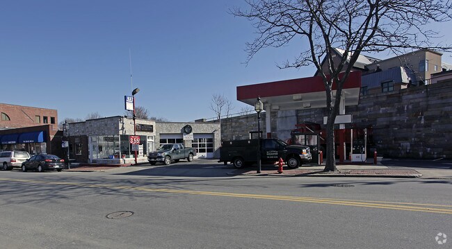
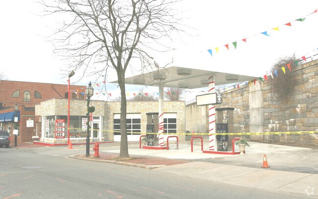
Property Record
585 Main St, Winchester, MA 01890


Property Detail
585 Main St
WINC-000009-000050
Middlesex
Servicestation
Massachusetts
AE The base floodplain where base flood elevations are provided. AE Zones are now used on new format FIRMs instead of A1-A30 Zones.
0.17 AC
2025
Burlington/Woburn
2025
Boston
338200
Boston-Cambridge-Newton, MA-NH
2,147 SF
NEARBY LISTINGS FOR SALE OR LEASE
DEMOGRAPHICS near 585 Main St
1 mile
3 mile
5 mile
2024 Total Population
15,169
123,974
441,710
2029 Population
15,856
128,353
454,833
Pop Growth 2024-2029
+ 4.53%
+ 3.53%
+ 2.97%
Average Age
41
42
41
2024 Total Households
5,283
49,379
177,840
HH Growth 2024-2029
+ 4.62%
+ 3.60%
+ 3.11%
Median Household Inc
$196,144
$132,139
$127,202
Avg Household Size
2.80
2.40
2.40
2024 Avg HH Vehicles
2.00
2.00
2.00
Median Home Value
$1,068,953
$827,173
$826,387
Median Year Built
1949
1954
1952
Nearby Places
Map Layers
Map Styles
 Street
 Aerial
Transit
 Traffic
 Biking
Places
Listings with unknown addresses are not visible on the map
- Restaurants
- Banks
- Shops
- Fitness
- Groceries
PUBLIC TRANSPORTATION
COMMUTER RAIL
Winchester Center (Lowell Line - Massachusetts Bay Transportation Authority Commuter Rail (Purple Line))
Drive
Walk
Distance
Winchester Center (Lowell Line - Massachusetts Bay Transportation Authority Commuter Rail (Purple Line))
1 min
6 min
0.2 mi
Wedgemere (Lowell Line - Massachusetts Bay Transportation Authority Commuter Rail (Purple Line))
Drive
Walk
Distance
Wedgemere (Lowell Line - Massachusetts Bay Transportation Authority Commuter Rail (Purple Line))
3 min
18 min
0.9 mi
AIRPORT
General Edward Lawrence Logan International
Drive
Walk
Distance
General Edward Lawrence Logan International
20 min
11.2 mi
Manchester Boston Regional
Drive
Walk
Distance
Manchester Boston Regional
62 min
43.7 mi
Freight Ports
Port of Boston
Drive
Walk
Distance
Port of Boston
20 min
10.9 mi
Nearby Properties
Address
Land Use
TOTAL SIZE
Lot Size
Zoning
Address
Land Use
TOTAL SIZE
Lot Size
Zoning
530,113 SF
29.43 AC
Address
Land Use
TOTAL SIZE
Lot Size
Zoning
169 AC
OS
Address
Land Use
TOTAL SIZE
Lot Size
Zoning
21,024 SF
18.19 AC
Address
Land Use
TOTAL SIZE
Lot Size
Zoning
14.97 AC
C
Address
Land Use
TOTAL SIZE
Lot Size
Zoning
153,732 SF
12.50 AC
SCI
Address
Land Use
TOTAL SIZE
Lot Size
Zoning
44.94 AC
R2
Address
Land Use
TOTAL SIZE
Lot Size
Zoning
208,852 SF
16.17 AC
MU
Address
Land Use
TOTAL SIZE
Lot Size
Zoning
0.47 AC
M
Address
Land Use
TOTAL SIZE
Lot Size
Zoning
11.72 AC
Address
Land Use
TOTAL SIZE
Lot Size
Zoning
157,317 SF
3.87 AC
B2A
Address
Land Use
TOTAL SIZE
Lot Size
Zoning
720 SF
632 AC
SA8
Address
Land Use
TOTAL SIZE
Lot Size
Zoning
55,217 SF
1.95 AC
I
Address
Land Use
TOTAL SIZE
Lot Size
Zoning
186,516 SF
40 AC
R-1
Address
Land Use
TOTAL SIZE
Lot Size
Zoning
191,050 SF
3.15 AC
Address
Land Use
TOTAL SIZE
Lot Size
Zoning
183,702 SF
2.75 AC
B5
Address
Land Use
TOTAL SIZE
Lot Size
Zoning
189,822 SF
3.50 AC
Address
Land Use
TOTAL SIZE
Lot Size
Zoning
9.50 AC
SCI
Address
Land Use
TOTAL SIZE
Lot Size
Zoning
127.30 AC
R-1
Address
Land Use
TOTAL SIZE
Lot Size
Zoning
157,305 SF
10.69 AC
RDB
Address
Land Use
TOTAL SIZE
Lot Size
Zoning
83,227 SF
16.82 AC
RDA
Address
Land Use
TOTAL SIZE
Lot Size
Zoning
5.63 AC
C
Address
Land Use
TOTAL SIZE
Lot Size
Zoning
8.17 AC
RB
Address
Land Use
TOTAL SIZE
Lot Size
Zoning
9 AC
C/R
Address
Land Use
TOTAL SIZE
Lot Size
Zoning
68,876 SF
17.10 AC
R-1
Address
Land Use
TOTAL SIZE
Lot Size
Zoning
15.85 AC
R-3
Address
Land Use
TOTAL SIZE
Lot Size
Zoning
53,415 SF
11.02 AC
SCI
Address
Land Use
TOTAL SIZE
Lot Size
Zoning
62,853 SF
17.32 AC
R-2
Address
Land Use
TOTAL SIZE
Lot Size
Zoning
1,815 SF
2.99 AC
RDA
Address
Land Use
TOTAL SIZE
Lot Size
Zoning
154,380 SF
7.15 AC
R1
Address
Land Use
TOTAL SIZE
Lot Size
Zoning
107,759 SF
22.42 AC
R-1
The World's #1 Commercial Real Estate Marketplace
Connect with us
© 2026 CoStar Group
The information above has been obtained from sources believed reliable. While we do not doubt its accuracy we have not verified it and make no guarantee, warranty or representation about it. It is your responsibility to independently confirm its accuracy and completeness. Any projections, opinions, assumptions, or estimates used are for example only and do not represent the current or future performance of the property. The value of this transaction to you depends on tax and other factors which should be evaluated by your tax, financial, and legal advisors. You and your advisors should conduct a careful, independent investigation of the property to determine to your satisfaction the suitability of the property for your needs.