Property Record
11660 Sw 97Th Ter, Ocala, FL 34481


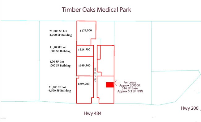
Property Detail
11660 Sw 97Th Ter
35341-100100
SEC 35 TWP 16 RGE 20 PLAT BOOK 012 PAGE 045 TIMBER OAKS PROFESSIONAL PARK LOT 1
Officebuilding
Marion
PUD
Florida
B and X Area of moderate flood hazard, usually the area between the limits of the 100-year and 500-year floods.
1
2025
0.45 AC
2025
Outlying Marion County
001005
Ocala
5,045 SF
Ocala, FL
NEARBY LISTINGS FOR SALE OR LEASE
-
-
View all Ocala listings for lease on LoopNet.com
DEMOGRAPHICS near 11660 Sw 97Th Ter
1 mile
3 mile
5 mile
2025 Total Population
604
20,940
48,850
2030 Population
676
23,657
55,547
Pop Growth 2025-2030
+ 11.92%
+ 12.98%
+ 13.71%
Average Age
70
64
58
2025 Total Households
347
11,325
23,922
HH Growth 2025-2030
+ 12.10%
+ 13.05%
+ 13.77%
Median Household Inc
$56,124
$57,120
$59,851
Avg Household Size
1.70
1.80
2.00
2025 Avg HH Vehicles
1.00
1.00
2.00
Median Home Value
$262,233
$252,826
$285,928
Median Year Built
1993
1995
1999
Nearby Places
Map Layers
Map Styles
 Street
 Aerial
Transit
 Traffic
 Biking
Places
Listings with unknown addresses are not visible on the map
- Restaurants
- Banks
- Shops
- Fitness
- Groceries
SALE & LEASE HISTORY
LISTING DATE
SALE/LEASE

Jun 10, 2019
For Lease
Nearby Properties
Address
Land Use
TOTAL SIZE
Lot Size
Zoning
Address
Land Use
TOTAL SIZE
Lot Size
Zoning
96,094 SF
13.66 AC
B2
Address
Land Use
TOTAL SIZE
Lot Size
Zoning
103,410 SF
27.04 AC
PUD
Address
Land Use
TOTAL SIZE
Lot Size
Zoning
74,928 SF
7.80 AC
PUD
Address
Land Use
TOTAL SIZE
Lot Size
Zoning
210,937 SF
27.08 AC
B4
Address
Land Use
TOTAL SIZE
Lot Size
Zoning
3,474.32 AC
A1
Address
Land Use
TOTAL SIZE
Lot Size
Zoning
28,813 SF
70.30 AC
B4
Address
Land Use
TOTAL SIZE
Lot Size
Zoning
18,035 SF
3.33 AC
B2
Address
Land Use
TOTAL SIZE
Lot Size
Zoning
43,619 SF
6.04 AC
R3
Address
Land Use
TOTAL SIZE
Lot Size
Zoning
101,312 SF
5,201.15 AC
A1
Address
Land Use
TOTAL SIZE
Lot Size
Zoning
98,205 SF
13.41 AC
B2
Address
Land Use
TOTAL SIZE
Lot Size
Zoning
88,777 SF
10.50 AC
B4
Address
Land Use
TOTAL SIZE
Lot Size
Zoning
69,278 SF
7.52 AC
B4
Address
Land Use
TOTAL SIZE
Lot Size
Zoning
68,180 SF
5.40 AC
B5
Address
Land Use
TOTAL SIZE
Lot Size
Zoning
82,904 SF
10.51 AC
B2
Address
Land Use
TOTAL SIZE
Lot Size
Zoning
16,729 SF
5 AC
B4
Address
Land Use
TOTAL SIZE
Lot Size
Zoning
27,563 SF
3.03 AC
B4
Address
Land Use
TOTAL SIZE
Lot Size
Zoning
47,378 SF
23.26 AC
A1
Address
Land Use
TOTAL SIZE
Lot Size
Zoning
286.80 AC
PUD
Address
Land Use
TOTAL SIZE
Lot Size
Zoning
16,214 SF
4.91 AC
B2
Address
Land Use
TOTAL SIZE
Lot Size
Zoning
37,213 SF
14.54 AC
A1
Address
Land Use
TOTAL SIZE
Lot Size
Zoning
27,862 SF
17.04 AC
A1
Address
Land Use
TOTAL SIZE
Lot Size
Zoning
41,642 SF
5.47 AC
B4
Address
Land Use
TOTAL SIZE
Lot Size
Zoning
20,288 SF
7.20 AC
B2
Address
Land Use
TOTAL SIZE
Lot Size
Zoning
955 AC
A1
Address
Land Use
TOTAL SIZE
Lot Size
Zoning
17,428 SF
2.01 AC
B4
Address
Land Use
TOTAL SIZE
Lot Size
Zoning
45,364 SF
6.69 AC
B2
Address
Land Use
TOTAL SIZE
Lot Size
Zoning
16,308 SF
1.74 AC
B2
Address
Land Use
TOTAL SIZE
Lot Size
Zoning
30,847 SF
6 AC
A1
Address
Land Use
TOTAL SIZE
Lot Size
Zoning
16,954 SF
1.68 AC
B4
Address
Land Use
TOTAL SIZE
Lot Size
Zoning
13,089 SF
1.72 AC
B2
The World's #1 Commercial Real Estate Marketplace
Connect with us
© 2026 CoStar Group
The information above has been obtained from sources believed reliable. While we do not doubt its accuracy we have not verified it and make no guarantee, warranty or representation about it. It is your responsibility to independently confirm its accuracy and completeness. Any projections, opinions, assumptions, or estimates used are for example only and do not represent the current or future performance of the property. The value of this transaction to you depends on tax and other factors which should be evaluated by your tax, financial, and legal advisors. You and your advisors should conduct a careful, independent investigation of the property to determine to your satisfaction the suitability of the property for your needs.