Property Record
208 Crock Wells Mill Dr, Winchester, VA 22603
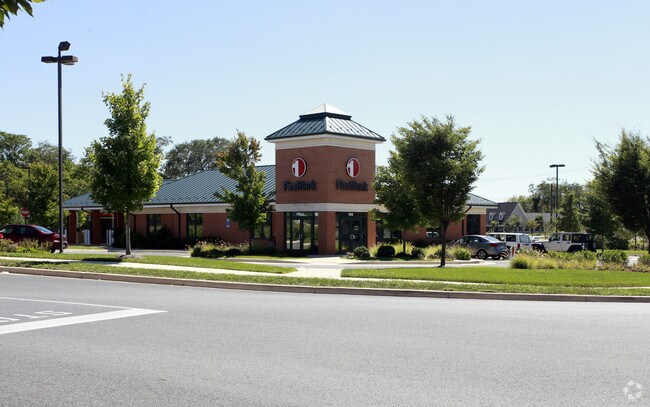

Property Detail
208 Crock Wells Mill Dr
52A-L
OUTLOT 6 1.53 ACRES
Multipleuses
Frederick
B2
Virginia
B and X Area of moderate flood hazard, usually the area between the limits of the 100-year and 500-year floods.
1.53 AC
2025
Frederick County
2025
Washington, DC
050500
Winchester, VA-WV
4,120 SF
NEARBY LISTINGS FOR SALE OR LEASE
DEMOGRAPHICS near 208 Crock Wells Mill Dr
1 mile
3 mile
5 mile
2025 Total Population
1,985
29,676
58,606
2030 Population
2,051
29,738
59,829
Pop Growth 2025-2030
+ 3.32%
+ 0.21%
+ 2.09%
Average Age
50
41
41
2025 Total Households
864
12,263
22,732
HH Growth 2025-2030
+ 3.47%
+ 0.16%
+ 1.95%
Median Household Inc
$96,508
$69,995
$72,744
Avg Household Size
2.20
2.30
2.40
2025 Avg HH Vehicles
2.00
2.00
2.00
Median Home Value
$482,499
$393,806
$360,122
Median Year Built
2000
1975
1982
Nearby Places
Map Layers
Map Styles
 Street
 Aerial
Transit
 Traffic
 Biking
Places
Listings with unknown addresses are not visible on the map
- Restaurants
- Banks
- Shops
- Fitness
- Groceries
Nearby Properties
Address
Land Use
TOTAL SIZE
Lot Size
Zoning
Address
Land Use
TOTAL SIZE
Lot Size
Zoning
979,509 SF
161.49 AC
MC
Address
Land Use
TOTAL SIZE
Lot Size
Zoning
90,399 SF
131.06 AC
MS
Address
Land Use
TOTAL SIZE
Lot Size
Zoning
47,089 SF
16.84 AC
LR
Address
Land Use
TOTAL SIZE
Lot Size
Zoning
10,821 SF
68.86 AC
RA
Address
Land Use
TOTAL SIZE
Lot Size
Zoning
33,264 SF
10.59 AC
MR
Address
Land Use
TOTAL SIZE
Lot Size
Zoning
191,138 SF
35 AC
EIP
Address
Land Use
TOTAL SIZE
Lot Size
Zoning
11,979 SF
10.82 AC
HR
Address
Land Use
TOTAL SIZE
Lot Size
Zoning
27,464 SF
8.53 AC
B2
Address
Land Use
TOTAL SIZE
Lot Size
Zoning
65,320 SF
2.62 AC
B1
Address
Land Use
TOTAL SIZE
Lot Size
Zoning
64,711 SF
18.10 AC
B2
Address
Land Use
TOTAL SIZE
Lot Size
Zoning
5,293 SF
195.07 AC
LR
Address
Land Use
TOTAL SIZE
Lot Size
Zoning
96,721 SF
9.19 AC
EIP
Address
Land Use
TOTAL SIZE
Lot Size
Zoning
94,606 SF
4.92 AC
B2
Address
Land Use
TOTAL SIZE
Lot Size
Zoning
20,844 SF
11.58 AC
RP
Address
Land Use
TOTAL SIZE
Lot Size
Zoning
199,053 SF
20.53 AC
B2
Address
Land Use
TOTAL SIZE
Lot Size
Zoning
151,000 SF
26.91 AC
LR
Address
Land Use
TOTAL SIZE
Lot Size
Zoning
83,786 SF
2.71 AC
HE1
Address
Land Use
TOTAL SIZE
Lot Size
Zoning
73,226 SF
10.24 AC
B2
Address
Land Use
TOTAL SIZE
Lot Size
Zoning
91,468 SF
7.37 AC
EIP
Address
Land Use
TOTAL SIZE
Lot Size
Zoning
69,975 SF
14.77 AC
B2
Address
Land Use
TOTAL SIZE
Lot Size
Zoning
43,232 SF
169.19 AC
EIP
Address
Land Use
TOTAL SIZE
Lot Size
Zoning
74,336 SF
8.91 AC
MC
Address
Land Use
TOTAL SIZE
Lot Size
Zoning
12,000 SF
8.78 AC
CM1
Address
Land Use
TOTAL SIZE
Lot Size
Zoning
67,200 SF
16.89 AC
M1
Address
Land Use
TOTAL SIZE
Lot Size
Zoning
57,276 SF
1.07 AC
EIP
Address
Land Use
TOTAL SIZE
Lot Size
Zoning
31,134 SF
7.53 AC
MR
Address
Land Use
TOTAL SIZE
Lot Size
Zoning
75,734 SF
10 AC
RA
Address
Land Use
TOTAL SIZE
Lot Size
Zoning
51,550 SF
2.12 AC
EIP
Address
Land Use
TOTAL SIZE
Lot Size
Zoning
3,332 SF
6.86 AC
HR
Address
Land Use
TOTAL SIZE
Lot Size
Zoning
169,744 SF
9.68 AC
HR
The World's #1 Commercial Real Estate Marketplace
Connect with us
© 2026 CoStar Group
The information above has been obtained from sources believed reliable. While we do not doubt its accuracy we have not verified it and make no guarantee, warranty or representation about it. It is your responsibility to independently confirm its accuracy and completeness. Any projections, opinions, assumptions, or estimates used are for example only and do not represent the current or future performance of the property. The value of this transaction to you depends on tax and other factors which should be evaluated by your tax, financial, and legal advisors. You and your advisors should conduct a careful, independent investigation of the property to determine to your satisfaction the suitability of the property for your needs.