Property Record
120 N Trade Ave, Landrum, SC 29356
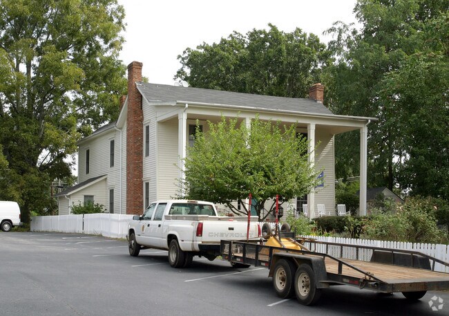
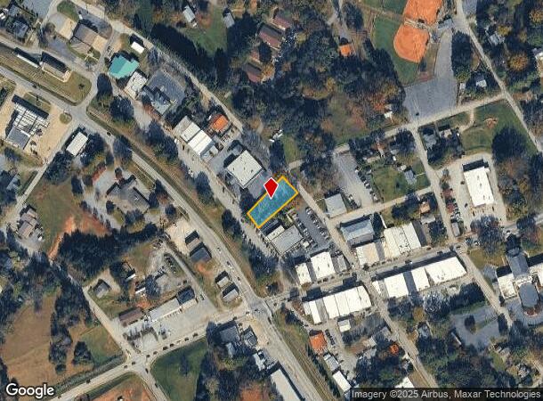

Property Detail
120 N Trade Ave
1-08-01-011.01
Survey For Tolly W Petty
Commercialnec
E SIDE N TRADE ST & N OF E RUTHERFORD ST PB 91-708 PB 151-43 DB 134H-706
X
Spartanburg
45083C0012D
South Carolina
2024
0.30 AC
2025
Upper Spartanburg County
022600
Greenville/Spartanburg
4,851 SF
Spartanburg, SC
NEARBY LISTINGS FOR SALE OR LEASE
-
-
View all Landrum listings for sale on LoopNet.com
DEMOGRAPHICS near 120 N Trade Ave
1 mile
3 mile
5 mile
2024 Total Population
2,578
6,423
15,655
2029 Population
2,932
7,284
17,491
Pop Growth 2024-2029
+ 13.73%
+ 13.40%
+ 11.73%
Average Age
44
46
48
2024 Total Households
1,136
2,780
6,876
HH Growth 2024-2029
+ 13.91%
+ 13.56%
+ 11.78%
Median Household Inc
$49,428
$54,889
$54,633
Avg Household Size
2.30
2.30
2.20
2024 Avg HH Vehicles
2.00
2.00
2.00
Median Home Value
$198,321
$250,767
$265,847
Median Year Built
1975
1979
1981
Nearby Places
Map Layers
Map Styles
 Street
 Aerial
Transit
 Traffic
 Biking
Places
Listings with unknown addresses are not visible on the map
- Restaurants
- Banks
- Shops
- Fitness
- Groceries
PUBLIC TRANSPORTATION
AIRPORT
Greenville Spartanburg International
Drive
Walk
Distance
Greenville Spartanburg International
36 min
22.2 mi
Asheville Regional
Drive
Walk
Distance
Asheville Regional
44 min
34.1 mi
SALE & LEASE HISTORY
LISTING DATE
SALE/LEASE

Sep 24, 2016
For Sale
Sep 17, 2020
For Sale
Oct 25, 2018
For Sale
Nov 20, 2020
For Sale
Dec 17, 2019
For Sale
Aug 24, 2019
For Sale
Apr 20, 2018
For Sale
Nearby Properties
Address
Land Use
TOTAL SIZE
Lot Size
Zoning
Address
Land Use
TOTAL SIZE
Lot Size
Zoning
166.74 AC
RE5
Address
Land Use
TOTAL SIZE
Lot Size
Zoning
4,579 SF
68 AC
RE5
Address
Land Use
TOTAL SIZE
Lot Size
Zoning
7,703 SF
190.87 AC
RE5
Address
Land Use
TOTAL SIZE
Lot Size
Zoning
3,462 SF
24.05 AC
RE5
Address
Land Use
TOTAL SIZE
Lot Size
Zoning
5,516 SF
36.36 AC
RE5
Address
Land Use
TOTAL SIZE
Lot Size
Zoning
1,455 SF
66.84 AC
M
Address
Land Use
TOTAL SIZE
Lot Size
Zoning
2,290 SF
23.19 AC
RE5
Address
Land Use
TOTAL SIZE
Lot Size
Zoning
728 SF
55.77 AC
RE5
Address
Land Use
TOTAL SIZE
Lot Size
Zoning
3,102 SF
21.74 AC
RE5
Address
Land Use
TOTAL SIZE
Lot Size
Zoning
3,030 SF
14.53 AC
RE5
Address
Land Use
TOTAL SIZE
Lot Size
Zoning
686 SF
44.91 AC
RE5
Address
Land Use
TOTAL SIZE
Lot Size
Zoning
2,564 SF
285.70 AC
RE5
Address
Land Use
TOTAL SIZE
Lot Size
Zoning
3,684 SF
36.77 AC
MX
Address
Land Use
TOTAL SIZE
Lot Size
Zoning
478 SF
12 AC
M
Address
Land Use
TOTAL SIZE
Lot Size
Zoning
3,585 SF
7.02 AC
RE5
Address
Land Use
TOTAL SIZE
Lot Size
Zoning
3,923 SF
26.36 AC
M
Address
Land Use
TOTAL SIZE
Lot Size
Zoning
2,512 SF
34.04 AC
RE5
Address
Land Use
TOTAL SIZE
Lot Size
Zoning
3,149 SF
40.74 AC
RE5
Address
Land Use
TOTAL SIZE
Lot Size
Zoning
14.59 AC
RE5
Address
Land Use
TOTAL SIZE
Lot Size
Zoning
2,713 SF
10.12 AC
M
Address
Land Use
TOTAL SIZE
Lot Size
Zoning
36.32 AC
RE5
Address
Land Use
TOTAL SIZE
Lot Size
Zoning
1,726 SF
43.74 AC
RE5
Address
Land Use
TOTAL SIZE
Lot Size
Zoning
2,812 SF
3.26 AC
RE5
Address
Land Use
TOTAL SIZE
Lot Size
Zoning
1,956 SF
18.40 AC
RE5
Address
Land Use
TOTAL SIZE
Lot Size
Zoning
2,168 SF
8.04 AC
M
Address
Land Use
TOTAL SIZE
Lot Size
Zoning
3,169 SF
5.73 AC
M
Address
Land Use
TOTAL SIZE
Lot Size
Zoning
3,046 SF
5.66 AC
M
Address
Land Use
TOTAL SIZE
Lot Size
Zoning
2,476 SF
15.26 AC
RE5
Address
Land Use
TOTAL SIZE
Lot Size
Zoning
2,608 SF
5.76 AC
RE5
Address
Land Use
TOTAL SIZE
Lot Size
Zoning
6.17 AC
M
The World's #1 Commercial Real Estate Marketplace
Connect with us
© 2026 CoStar Group
The information above has been obtained from sources believed reliable. While we do not doubt its accuracy we have not verified it and make no guarantee, warranty or representation about it. It is your responsibility to independently confirm its accuracy and completeness. Any projections, opinions, assumptions, or estimates used are for example only and do not represent the current or future performance of the property. The value of this transaction to you depends on tax and other factors which should be evaluated by your tax, financial, and legal advisors. You and your advisors should conduct a careful, independent investigation of the property to determine to your satisfaction the suitability of the property for your needs.