Property Record
502 Park Ave, Stroudsburg, PA 18360
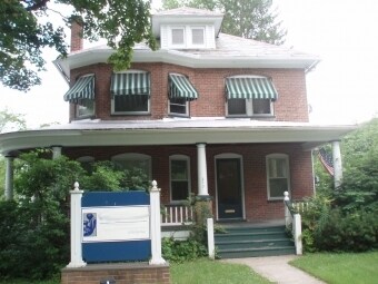


Property Detail
502 Park Ave
18-5.2.7.5
LOTS 1 & 2
Officebuilding
Monroe
R-1
Pennsylvania
B and X Area of moderate flood hazard, usually the area between the limits of the 100-year and 500-year floods.
1-2
2025
0.16 AC
2025
Monroe County
300801
Philadelphia
2,664 SF
East Stroudsburg, PA
NEARBY LISTINGS FOR SALE OR LEASE
DEMOGRAPHICS near 502 Park Ave
1 mile
3 mile
5 mile
2025 Total Population
5,049
28,170
44,455
2030 Population
4,819
27,880
43,743
Pop Growth 2025-2030
(4.56%)
(1.03%)
(1.60%)
Average Age
43
41
42
2025 Total Households
2,199
10,727
16,368
HH Growth 2025-2030
(4.68%)
(0.86%)
(1.44%)
Median Household Inc
$56,574
$58,798
$65,953
Avg Household Size
2.20
2.40
2.50
2025 Avg HH Vehicles
2.00
2.00
2.00
Median Home Value
$262,499
$273,912
$292,486
Median Year Built
1965
1976
1981
Nearby Places
Map Layers
Map Styles
 Street
 Aerial
Transit
 Traffic
 Biking
Places
Listings with unknown addresses are not visible on the map
- Restaurants
- Banks
- Shops
- Fitness
- Groceries
PUBLIC TRANSPORTATION
AIRPORT
Lehigh Valley International
Drive
Walk
Distance
Lehigh Valley International
50 min
32.8 mi
Freight Ports
Maher Terminal
Drive
Walk
Distance
Maher Terminal
87 min
69.5 mi
Nearby Properties
Address
Land Use
TOTAL SIZE
Lot Size
Zoning
Address
Land Use
TOTAL SIZE
Lot Size
Zoning
412,170 SF
Address
Land Use
TOTAL SIZE
Lot Size
Zoning
260,728 SF
23.15 AC
IU
Address
Land Use
TOTAL SIZE
Lot Size
Zoning
225,935 SF
3.74 AC
IM
Address
Land Use
TOTAL SIZE
Lot Size
Zoning
265,064 SF
107.97 AC
R-1
Address
Land Use
TOTAL SIZE
Lot Size
Zoning
102,240 SF
34.13 AC
R-2
Address
Land Use
TOTAL SIZE
Lot Size
Zoning
254,320 SF
0.23 AC
IU
Address
Land Use
TOTAL SIZE
Lot Size
Zoning
16,664 SF
43.49 AC
R2
Address
Land Use
TOTAL SIZE
Lot Size
Zoning
48,796 SF
5.69 AC
C-1A
Address
Land Use
TOTAL SIZE
Lot Size
Zoning
91,431 SF
Address
Land Use
TOTAL SIZE
Lot Size
Zoning
112,582 SF
26.38 AC
B2
Address
Land Use
TOTAL SIZE
Lot Size
Zoning
140,177 SF
16.16 AC
C-1
Address
Land Use
TOTAL SIZE
Lot Size
Zoning
64,736 SF
1.53 AC
MU-B
Address
Land Use
TOTAL SIZE
Lot Size
Zoning
52,230 SF
8 AC
IU
Address
Land Use
TOTAL SIZE
Lot Size
Zoning
129,257 SF
1.92 AC
IU
Address
Land Use
TOTAL SIZE
Lot Size
Zoning
104,753 SF
24 AC
C-2
Address
Land Use
TOTAL SIZE
Lot Size
Zoning
126,740 SF
1.67 AC
IU
Address
Land Use
TOTAL SIZE
Lot Size
Zoning
90,072 SF
3.15 AC
IU
Address
Land Use
TOTAL SIZE
Lot Size
Zoning
216 SF
109.59 AC
S-1
Address
Land Use
TOTAL SIZE
Lot Size
Zoning
20,984 SF
14.30 AC
I-E
Address
Land Use
TOTAL SIZE
Lot Size
Zoning
201,578 SF
21.19 AC
OM-1
Address
Land Use
TOTAL SIZE
Lot Size
Zoning
83,103 SF
30.80 AC
IU
Address
Land Use
TOTAL SIZE
Lot Size
Zoning
48,364 SF
5.57 AC
C-4
Address
Land Use
TOTAL SIZE
Lot Size
Zoning
47,628 SF
4.40 AC
C1
Address
Land Use
TOTAL SIZE
Lot Size
Zoning
60,723 SF
2.94 AC
IM
Address
Land Use
TOTAL SIZE
Lot Size
Zoning
34,352 SF
9.83 AC
C1
Address
Land Use
TOTAL SIZE
Lot Size
Zoning
113,052 SF
1.56 AC
C-2
Address
Land Use
TOTAL SIZE
Lot Size
Zoning
179,576 SF
1.76 AC
C-2
Address
Land Use
TOTAL SIZE
Lot Size
Zoning
40,978 SF
0.45 AC
C1
Address
Land Use
TOTAL SIZE
Lot Size
Zoning
8,740 SF
9.25 AC
R-2
Address
Land Use
TOTAL SIZE
Lot Size
Zoning
52,322 SF
2.93 AC
C-2
The World's #1 Commercial Real Estate Marketplace
Connect with us
© 2026 CoStar Group
The information above has been obtained from sources believed reliable. While we do not doubt its accuracy we have not verified it and make no guarantee, warranty or representation about it. It is your responsibility to independently confirm its accuracy and completeness. Any projections, opinions, assumptions, or estimates used are for example only and do not represent the current or future performance of the property. The value of this transaction to you depends on tax and other factors which should be evaluated by your tax, financial, and legal advisors. You and your advisors should conduct a careful, independent investigation of the property to determine to your satisfaction the suitability of the property for your needs.