Property Record
4750 Lindle Rd, Harrisburg, PA 17111
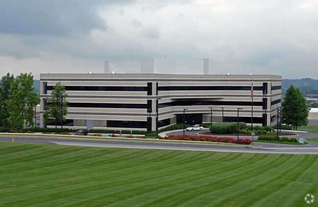

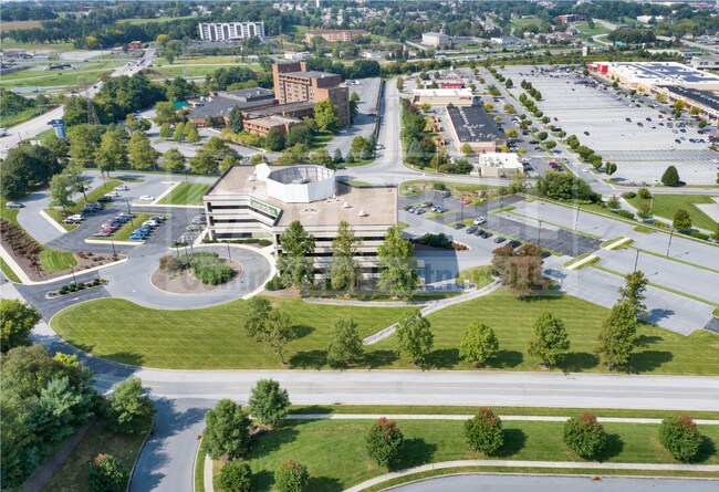

Property Detail
4750 Lindle Rd
63-027-157
Dauphin
Officebuilding
Pennsylvania
B and X Area of moderate flood hazard, usually the area between the limits of the 100-year and 500-year floods.
8.07 AC
2025
Harrisburg Area East
2025
Philadelphia
022800
Harrisburg-Carlisle, PA
80,524 SF
NEARBY LISTINGS FOR SALE OR LEASE
DEMOGRAPHICS near 4750 Lindle Rd
1 mile
3 mile
5 mile
2025 Total Population
3,769
60,907
166,269
2030 Population
3,816
61,887
169,708
Pop Growth 2025-2030
+ 1.25%
+ 1.61%
+ 2.07%
Average Age
41
40
40
2025 Total Households
1,477
23,948
67,982
HH Growth 2025-2030
+ 1.35%
+ 1.61%
+ 2.19%
Median Household Inc
$81,038
$68,061
$68,478
Avg Household Size
2.40
2.40
2.30
2025 Avg HH Vehicles
2.00
2.00
2.00
Median Home Value
$236,404
$205,185
$225,492
Median Year Built
1968
1967
1964
Nearby Places
Map Layers
Map Styles
 Street
 Aerial
Transit
 Traffic
 Biking
Places
Listings with unknown addresses are not visible on the map
- Restaurants
- Banks
- Shops
- Fitness
- Groceries
PUBLIC TRANSPORTATION
COMMUTER RAIL
Drive
Walk
Distance
10 min
5.1 mi
Drive
Walk
Distance
14 min
6.5 mi
AIRPORT
Harrisburg International
Drive
Walk
Distance
Harrisburg International
12 min
6.4 mi
SALE & LEASE HISTORY
LISTING DATE
SALE/LEASE

Sep 20, 2022
For Lease
Nearby Properties
Address
Land Use
TOTAL SIZE
Lot Size
Zoning
Address
Land Use
TOTAL SIZE
Lot Size
Zoning
210,464 SF
28.80 AC
Address
Land Use
TOTAL SIZE
Lot Size
Zoning
74,032 SF
74.81 AC
Address
Land Use
TOTAL SIZE
Lot Size
Zoning
122,301 SF
32.30 AC
Address
Land Use
TOTAL SIZE
Lot Size
Zoning
570,800 SF
1.29 AC
Address
Land Use
TOTAL SIZE
Lot Size
Zoning
47,022 SF
47.55 AC
Address
Land Use
TOTAL SIZE
Lot Size
Zoning
Address
Land Use
TOTAL SIZE
Lot Size
Zoning
172,289 SF
86.54 AC
Address
Land Use
TOTAL SIZE
Lot Size
Zoning
91,929 SF
45.10 AC
Address
Land Use
TOTAL SIZE
Lot Size
Zoning
2,913 SF
24.28 AC
Address
Land Use
TOTAL SIZE
Lot Size
Zoning
284,737 SF
28.16 AC
Address
Land Use
TOTAL SIZE
Lot Size
Zoning
5,588 SF
9.29 AC
Address
Land Use
TOTAL SIZE
Lot Size
Zoning
27,632 SF
59.50 AC
Address
Land Use
TOTAL SIZE
Lot Size
Zoning
2,000 SF
21.13 AC
Address
Land Use
TOTAL SIZE
Lot Size
Zoning
1,744 SF
21.79 AC
Address
Land Use
TOTAL SIZE
Lot Size
Zoning
2,068 SF
19.26 AC
Address
Land Use
TOTAL SIZE
Lot Size
Zoning
24,567 SF
15.33 AC
Address
Land Use
TOTAL SIZE
Lot Size
Zoning
33,916 SF
10 AC
Address
Land Use
TOTAL SIZE
Lot Size
Zoning
207,012 SF
24.50 AC
Address
Land Use
TOTAL SIZE
Lot Size
Zoning
13,348 SF
25.38 AC
Address
Land Use
TOTAL SIZE
Lot Size
Zoning
167,713 SF
11.50 AC
Address
Land Use
TOTAL SIZE
Lot Size
Zoning
348,615 SF
38.98 AC
Address
Land Use
TOTAL SIZE
Lot Size
Zoning
165,549 SF
65.10 AC
Address
Land Use
TOTAL SIZE
Lot Size
Zoning
1,254 SF
25.34 AC
Address
Land Use
TOTAL SIZE
Lot Size
Zoning
83,505 SF
11.50 AC
Address
Land Use
TOTAL SIZE
Lot Size
Zoning
97,887 SF
11.90 AC
Address
Land Use
TOTAL SIZE
Lot Size
Zoning
233,427 SF
20.38 AC
Address
Land Use
TOTAL SIZE
Lot Size
Zoning
41,360 SF
13.55 AC
Address
Land Use
TOTAL SIZE
Lot Size
Zoning
196,000 SF
12.42 AC
Address
Land Use
TOTAL SIZE
Lot Size
Zoning
61,198 SF
11.12 AC
Address
Land Use
TOTAL SIZE
Lot Size
Zoning
7,655 SF
219.86 AC
The World's #1 Commercial Real Estate Marketplace
Connect with us
© 2026 CoStar Group
The information above has been obtained from sources believed reliable. While we do not doubt its accuracy we have not verified it and make no guarantee, warranty or representation about it. It is your responsibility to independently confirm its accuracy and completeness. Any projections, opinions, assumptions, or estimates used are for example only and do not represent the current or future performance of the property. The value of this transaction to you depends on tax and other factors which should be evaluated by your tax, financial, and legal advisors. You and your advisors should conduct a careful, independent investigation of the property to determine to your satisfaction the suitability of the property for your needs.