Property Record
2335 Highway 136 Connector, Talking Rock, GA 30175

Property Detail
2335 Highway 136 Connector
033-000-147-002
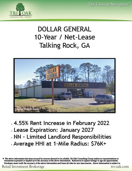
DIST24 LL271 1.1988AC DOLLAR GENERAL
Storebuilding
Pickens
NC
Georgia
B and X Area of moderate flood hazard, usually the area between the limits of the 100-year and 500-year floods.
1.20 AC
2025
Pickens County
2025
Atlanta
050400
Atlanta-Sandy Springs-Roswell, GA
7,760 SF
NEARBY LISTINGS FOR SALE OR LEASE
-
-
View all Talking Rock listings for sale on LoopNet.com
DEMOGRAPHICS near 2335 Highway 136 Connector
1 mile
3 mile
5 mile
2024 Total Population
645
3,261
7,346
2029 Population
727
3,663
8,244
Pop Growth 2024-2029
+ 12.71%
+ 12.33%
+ 12.22%
Average Age
42
41
42
2024 Total Households
234
1,186
2,684
HH Growth 2024-2029
+ 12.39%
+ 12.14%
+ 12.03%
Median Household Inc
$64,807
$66,190
$65,731
Avg Household Size
2.70
2.70
2.70
2024 Avg HH Vehicles
3.00
2.00
2.00
Median Home Value
$233,035
$242,562
$247,955
Median Year Built
2000
1997
1996
Nearby Places
Map Layers
Map Styles
 Street
 Aerial
Transit
 Traffic
 Biking
Places
Listings with unknown addresses are not visible on the map
- Restaurants
- Banks
- Shops
- Fitness
- Groceries
SALE & LEASE HISTORY
LISTING DATE
SALE/LEASE

Feb 26, 2020
For Sale
Nearby Properties
Address
Land Use
TOTAL SIZE
Lot Size
Zoning
Address
Land Use
TOTAL SIZE
Lot Size
Zoning
680.31 AC
SR
Address
Land Use
TOTAL SIZE
Lot Size
Zoning
40 AC
AG
Address
Land Use
TOTAL SIZE
Lot Size
Zoning
11,916 SF
7.22 AC
HB
Address
Land Use
TOTAL SIZE
Lot Size
Zoning
538.93 AC
AG
Address
Land Use
TOTAL SIZE
Lot Size
Zoning
37,345 SF
39.82 AC
I
Address
Land Use
TOTAL SIZE
Lot Size
Zoning
19,574 SF
35.16 AC
AG
Address
Land Use
TOTAL SIZE
Lot Size
Zoning
70.13 AC
AG
Address
Land Use
TOTAL SIZE
Lot Size
Zoning
707 SF
30.27 AC
AG
Address
Land Use
TOTAL SIZE
Lot Size
Zoning
273.01 AC
RR/SR
Address
Land Use
TOTAL SIZE
Lot Size
Zoning
219.51 AC
AG
Address
Land Use
TOTAL SIZE
Lot Size
Zoning
179.50 AC
AG
Address
Land Use
TOTAL SIZE
Lot Size
Zoning
15,000 SF
7.41 AC
I
Address
Land Use
TOTAL SIZE
Lot Size
Zoning
280.44 AC
AG
Address
Land Use
TOTAL SIZE
Lot Size
Zoning
130.05 AC
RR
Address
Land Use
TOTAL SIZE
Lot Size
Zoning
2,330 SF
3.40 AC
ER
Address
Land Use
TOTAL SIZE
Lot Size
Zoning
2,323 SF
3.10 AC
ER
Address
Land Use
TOTAL SIZE
Lot Size
Zoning
3,000 SF
2.72 AC
NC
Address
Land Use
TOTAL SIZE
Lot Size
Zoning
51.57 AC
AG
Address
Land Use
TOTAL SIZE
Lot Size
Zoning
1,761 SF
3.01 AC
RR
Address
Land Use
TOTAL SIZE
Lot Size
Zoning
67.26 AC
RR/SR
Address
Land Use
TOTAL SIZE
Lot Size
Zoning
46.76 AC
AG
Address
Land Use
TOTAL SIZE
Lot Size
Zoning
2,348 SF
2.91 AC
RR
Address
Land Use
TOTAL SIZE
Lot Size
Zoning
2,128 SF
6.45 AC
RR
Address
Land Use
TOTAL SIZE
Lot Size
Zoning
43.88 AC
UR
Address
Land Use
TOTAL SIZE
Lot Size
Zoning
205.71 AC
AG
Address
Land Use
TOTAL SIZE
Lot Size
Zoning
2,570 SF
3.02 AC
RR
Address
Land Use
TOTAL SIZE
Lot Size
Zoning
67.85 AC
RR
Address
Land Use
TOTAL SIZE
Lot Size
Zoning
59.88 AC
AG
Address
Land Use
TOTAL SIZE
Lot Size
Zoning
60.29 AC
RR
The World's #1 Commercial Real Estate Marketplace
Connect with us
© 2026 CoStar Group
The information above has been obtained from sources believed reliable. While we do not doubt its accuracy we have not verified it and make no guarantee, warranty or representation about it. It is your responsibility to independently confirm its accuracy and completeness. Any projections, opinions, assumptions, or estimates used are for example only and do not represent the current or future performance of the property. The value of this transaction to you depends on tax and other factors which should be evaluated by your tax, financial, and legal advisors. You and your advisors should conduct a careful, independent investigation of the property to determine to your satisfaction the suitability of the property for your needs.