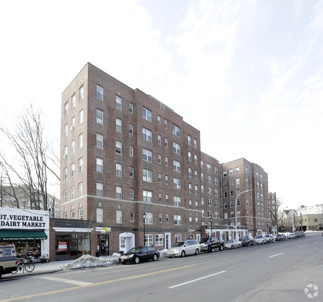
Property Record
13 Old Mamaroneck Rd, White Plains, NY 10605
Property Detail
13 Old Mamaroneck Rd
New York-Jersey City-White Plains, NY-NJ
WESTCHESTER
1700-130-036-00007-000-0001
New York
Apartment
1.000
B and X Area of moderate flood hazard, usually the area between the limits of the 100-year and 500-year floods.
0.80 AC
2025
White Plains
2024
Westchester/So Connecticut
009702
NEARBY LISTINGS FOR SALE OR LEASE
DEMOGRAPHICS near 13 Old Mamaroneck Rd
1 mile
3 mile
5 mile
2024 Total Population
36,095
114,956
242,794
2029 Population
36,953
116,926
245,340
Pop Growth 2024-2029
+ 2.38%
+ 1.71%
+ 1.05%
Average Age
42
43
42
2024 Total Households
16,063
44,424
88,341
HH Growth 2024-2029
+ 2.67%
+ 1.88%
+ 1.17%
Median Household Inc
$102,827
$129,049
$144,678
Avg Household Size
2.10
2.40
2.60
2024 Avg HH Vehicles
1.00
2.00
2.00
Median Home Value
$543,581
$701,989
$779,313
Median Year Built
1965
1961
1959
Nearby Places
Map Layers
Map Styles
 Street
 Aerial
Transit
 Traffic
 Biking
Places
Listings with unknown addresses are not visible on the map
- Restaurants
- Banks
- Shops
- Fitness
- Groceries
PUBLIC TRANSPORTATION
COMMUTER RAIL
White Plains Station (Harlem Line - Metro-North Commuter Railroad Company (Metro-North))
Drive
Walk
Distance
White Plains Station (Harlem Line - Metro-North Commuter Railroad Company (Metro-North))
3 min
1.3 mi
North White Plains Station (Harlem Line - Metro-North Commuter Railroad Company (Metro-North))
Drive
Walk
Distance
North White Plains Station (Harlem Line - Metro-North Commuter Railroad Company (Metro-North))
4 min
2.3 mi
AIRPORT
Westchester County
Drive
Walk
Distance
Westchester County
12 min
8.0 mi
LaGuardia
Drive
Walk
Distance
LaGuardia
39 min
22.7 mi
Freight Ports
NY - Red Hook Container Terminal
Drive
Walk
Distance
NY - Red Hook Container Terminal
54 min
33.2 mi
Nearby Properties
Address
Land Use
TOTAL SIZE
Lot Size
Zoning
Address
Land Use
TOTAL SIZE
Lot Size
Zoning
Address
Land Use
TOTAL SIZE
Lot Size
Zoning
381,836 SF
16.68 AC
A3
Address
Land Use
TOTAL SIZE
Lot Size
Zoning
75.87 AC
R-20
Address
Land Use
TOTAL SIZE
Lot Size
Zoning
66 AC
R-20
Address
Land Use
TOTAL SIZE
Lot Size
Zoning
237,313 SF
22.67 AC
A1
Address
Land Use
TOTAL SIZE
Lot Size
Zoning
16.22 AC
UR
Address
Land Use
TOTAL SIZE
Lot Size
Zoning
22.44 AC
R-20
Address
Land Use
TOTAL SIZE
Lot Size
Zoning
7.98 AC
CA
Address
Land Use
TOTAL SIZE
Lot Size
Zoning
1,975 SF
13.80 AC
CA
Address
Land Use
TOTAL SIZE
Lot Size
Zoning
10.90 AC
UR
Address
Land Use
TOTAL SIZE
Lot Size
Zoning
3.16 AC
Address
Land Use
TOTAL SIZE
Lot Size
Zoning
5.57 AC
AA1
Address
Land Use
TOTAL SIZE
Lot Size
Zoning
64.41 AC
R-20
Address
Land Use
TOTAL SIZE
Lot Size
Zoning
48,499 SF
8.52 AC
A2/A3
Address
Land Use
TOTAL SIZE
Lot Size
Zoning
1,200 SF
21.21 AC
R-20
Address
Land Use
TOTAL SIZE
Lot Size
Zoning
61,606 SF
19.99 AC
A4/A3
Address
Land Use
TOTAL SIZE
Lot Size
Zoning
7.98 AC
M-14
Address
Land Use
TOTAL SIZE
Lot Size
Zoning
0.58 AC
B
Address
Land Use
TOTAL SIZE
Lot Size
Zoning
48,267 SF
11.04 AC
A2 A
Address
Land Use
TOTAL SIZE
Lot Size
Zoning
11.21 AC
R-20
Address
Land Use
TOTAL SIZE
Lot Size
Zoning
84,450 SF
3.19 AC
B
Address
Land Use
TOTAL SIZE
Lot Size
Zoning
320 SF
5.38 AC
LI
Address
Land Use
TOTAL SIZE
Lot Size
Zoning
1,348 SF
5.67 AC
CA
Address
Land Use
TOTAL SIZE
Lot Size
Zoning
6.09 AC
DS
Address
Land Use
TOTAL SIZE
Lot Size
Zoning
1,630 SF
2.64 AC
LOB
Address
Land Use
TOTAL SIZE
Lot Size
Zoning
2,100 SF
24.12 AC
A3
Address
Land Use
TOTAL SIZE
Lot Size
Zoning
121.29 AC
Address
Land Use
TOTAL SIZE
Lot Size
Zoning
68,616 SF
3.11 AC
Address
Land Use
TOTAL SIZE
Lot Size
Zoning
2.26 AC
CA
Address
Land Use
TOTAL SIZE
Lot Size
Zoning
8.05 AC
R-10
The World's #1 Commercial Real Estate Marketplace
Connect with us
© 2026 CoStar Group
The information above has been obtained from sources believed reliable. While we do not doubt its accuracy we have not verified it and make no guarantee, warranty or representation about it. It is your responsibility to independently confirm its accuracy and completeness. Any projections, opinions, assumptions, or estimates used are for example only and do not represent the current or future performance of the property. The value of this transaction to you depends on tax and other factors which should be evaluated by your tax, financial, and legal advisors. You and your advisors should conduct a careful, independent investigation of the property to determine to your satisfaction the suitability of the property for your needs.